Is/Was Cornwall French?
New research from Plymouth University shows that lamprophyres from Cornwall and South Devon have more in common with those in Armorica (that is France) than they do with Avalonia (that is England). From this they deduce a terrane boundary between the two. The article is well worth looking at.
Very interesting, but not interesting enough for the Guardian who dress it up in terms such as "researchers have discovered that there is a corner of Britain that will forever belong to mainland Europe."
They cover the gist of the article well enough but this rock nationality stuff annoys me. So far, pebbles do not need to carry a passport.
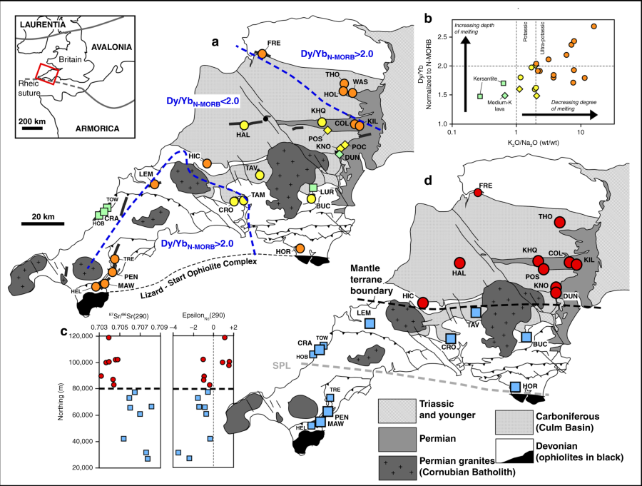 |
| Geospatial analysis of post-Variscan lamprophyre geochemistry in southwest Britain. Inset map shows location of study area, with the generally assumed location of the Rheic suture marked by the Lizard-Start ophiolites complex. a Map of the study area with sample localities. Samples marked with circles are minette-type lamprophyres, squares are kersantite lamprophyres, and diamonds are mica-free K-rich lavas. Samples are also colour-coded based on K2O/Na2O ratios. Orange samples are ultrapotassic (K2O/Na2O >2.2) and represent the lowest degree of mantle melting; yellow symbols are potassic (1 < K2O/Na2O <2.2) and green symbols represent samples with K2O/Na2O <1. Two dashed contour lines delineate areas in north and south where deepest-derived magmas were emplaced, based on N-MORB normalized Dy/Yb ratios >2. b Chart showing negative correlation between depth and degree of melting. c Initial Sr and Nd isotope ratios calculated at 290 Ma plotted against northing (Ordnance Survey UK grid coordinates), showing a clear jump in values across thick dashed line. d Map showing the samples assigned to group 1 (red circles) and group 2 (blue squares) based on their initial Sr and Nd isotope ratios. Surface trace of the boundary between the two isotopically distinct lithospheric mantle domains is interpreted as a cryptic terrane boundary in the mantle lithosphere buried beneath Paleozoic metasedimentary rocks. SPL refers to the Start-Perranporth Line (see text). Data for locations TOW (Towan Head), HOB (Holywell Beach), TRE (Trelissick), HEL (Helfort) and FRE (Fremington Quay) are from ref 35. (only Nd data); all other data from this study. Locations are listed in Supplementary Table 1. Map adapted from regional view geological map from British Geological Survey59. © Crown Copyright and Database Right 2018. Ordnance Survey (Digimap Licence) |
No comments:
Post a Comment