Thursday, 29 November 2018
Monday, 26 November 2018
How to deal with a lava flow - if you are a local authority in Hawaii
Lava Flow Housekeeping
I came across this video and found it fascinating. It is not very spectacular but has lots of fascinating details of dealing with a lava flow. If I ever have to protect an electricity pylon from a lava flow I know where to look!
GeoConservation Newsletter
GeoConservation Newsletter
The Autumn 2018 GeoConservation Newsletter has come my way and it is packed (in several senses) with news. You can get your copy HERE.
Saturday, 24 November 2018
26th November to 2nd December 2018
NEXT WEEKS EVENTS
26th November to 2nd December 2018
THE FOLLOWING IS AN EXTRACT FROM BRISTOL AND WEST COUNTRY GEOLOGY CALENDARS
MORE DETAILS CAN BE FOUND IN THE BRISTOL AND THE WEST COUNTRY CALENDARS AND ON THE WEB SITES OF THE RELEVANT SOCIETY OR ORGANISATION.
MONDAY 26TH
Course - Geology of the Bristol and Gloucester Region.
When
Mon, 26 November, 19:30 – 21:30
Where
Wynstones School, Stroud Road, Whaddon, Gloucester (map)
Description
Geology of the Bristol and Gloucester Region.
One of the most varied regions of Britain, spanning the major divisions of the Variscan Front/Bristol Channel-Bray Fault, and the Malvern fault/ Worcester Graben, incorporating rocks varying in age from late PreCambrian to Cretaceous, and three of the terranes making up the geological “jigsaw” of Britain. The course will cover roughly the area covered by the eponymous BGS publication in the British Regional Geology series (3rd edition 1992). Starts Mon 17th September for 10 weeks (not 22nd or29th Oct or 5th Nov), until 10th December Held at Wynstones School, Stroud Road, Whaddon, Gloucester from 7.30-9.30pm on Mondays. Cost £75 (including tea, coffee etc at breaktime!).
Contact Dave Green by email at davegeostudies@gmail.com, by phone at 01594 960858 and by post at Dave Green, Joys Green Farm, Lydbrook, Gloucestershire, GL17 9QU
Tuesday 27th
Wednesday 28th
Bristol Nats - lecture
When
Wed, 28 November, 19:30 – 21:00
Where
room G8, Wills Memorial Building, University of Bristol, BS8 1RJ (map)
Description
TRACE FOSSILS OF THE OLD RED SANDSTONE
Professor Susan Marriott Wednesday 28 November, 7.30 p.m.
Susan Marriott is Professor of Geology at the University of the West of England and has extensively studied the Old Red Sandstone and its trace fossils.
The Old Red Sandstone of the Anglo-Welsh Basin comprises predominantly continental red bed deposits of Late Silurian to Early Devonian age. Body fossils of terrestrial faunas in these deposits are poorly preserved and often fragmentary but a diverse assemblage of trace fossils is preserved giving an insight into faunal behaviours. This talk will concentrate on the trace fossils preserved in fine-grained components of alluvial facies that include: perennial and ephemeral rivers, floodplain lakes and alluvial fans. The associated ichnocoenoses (An assemblage of trace fossils made by members of a single community.) reflect the activities of aquatic and semi-aquatic fauna and include meniscate backfilled burrows and arthropod trackways, resting and foraging traces. The stratigraphic distribution indicates an increase in diversity from the Late Silurian into the Early Devonian.
It is intended that a Field meeting next summer to examine the Old Red Sandstone rocks in the Llansteffan area of Carmarthenshire will follow the talk.
Thursday 29th
Course - Understanding Geology and Scenery around Ross-on-Wye
When
Thu, 29 November, 10:00 – 10:30
Description
Understanding Geology and Scenery around Ross-on-Wye
Starts September 21st (not 25th Oct or 8th Nov), finishes 6th December.
This 10 week course aims to introduce you to the ways in which the varied and beautiful landscape round our area has come into being. The effects of folds, faults and tectonic dip in exposing different rock types, and the past and present processes of uplift, weathering, erosion and deposition that have acted upon them, will be examined by reference to local scenery. Use will be made of local maps and cross-sections across them, both geological and topographic; together with specimens of local rocks. Contact Paul Mason on 01989 760399. Cost £60 Enrol before 15th September to ensure that the course runs.
Friday 30th
Field course - Geology of the Quantocks and West Somerset
When
30 Nov – 2 Dec 2018
Description
Field Course: 30th Nov – 2nd Dec (and possibly Monday 3rd too) Geology of the Quantocks and West Somerset
A classic area for the study of the folded Upper Palaeozoic basement in the Quantocks and Cannington Park, and the unconformable Triassic and Jurassic sequence exposed in faulted basins associated with the Bristol Channel fault. What is the evidence for and against massive Variscan movement of formerly widely separated terranes along this fault? Excellent exposures, particularly of the Mesozoic rocks at and near the coast.
Contact Dave Green by email at davegeostudies@gmail.com, by phone at 01594 960858 and by post at Dave Green, Joys Green Farm, Lydbrook, Gloucestershire, GL17 9QU
saturday 1st December
FIELD COURSE - GEOLOGY OF THE QUANTOCKS AND WEST SOMERSET - see Friday
----------------------------------
OUGS Severnside - Day of Lectures
When
Saturday, 1 Dec 2018
Where
National Museum of Wales, Cathays Park, Cardiff CF10 3NP (map)
Sunday 2nd
FIELD COURSE - GEOLOGY OF THE QUANTOCKS AND WEST SOMERSET - SEE FRIDAY
Course - Geology of the Bristol and Gloucester Region.
When
Mon, 26 November, 19:30 – 21:30
Where
Wynstones School, Stroud Road, Whaddon, Gloucester (map)
Description
Geology of the Bristol and Gloucester Region.
One of the most varied regions of Britain, spanning the major divisions of the Variscan Front/Bristol Channel-Bray Fault, and the Malvern fault/ Worcester Graben, incorporating rocks varying in age from late PreCambrian to Cretaceous, and three of the terranes making up the geological “jigsaw” of Britain. The course will cover roughly the area covered by the eponymous BGS publication in the British Regional Geology series (3rd edition 1992). Starts Mon 17th September for 10 weeks (not 22nd or29th Oct or 5th Nov), until 10th December Held at Wynstones School, Stroud Road, Whaddon, Gloucester from 7.30-9.30pm on Mondays. Cost £75 (including tea, coffee etc at breaktime!).
Contact Dave Green by email at davegeostudies@gmail.com, by phone at 01594 960858 and by post at Dave Green, Joys Green Farm, Lydbrook, Gloucestershire, GL17 9QU
Bristol Nats - lecture
When
Wed, 28 November, 19:30 – 21:00
Where
room G8, Wills Memorial Building, University of Bristol, BS8 1RJ (map)
Description
TRACE FOSSILS OF THE OLD RED SANDSTONE
Professor Susan Marriott Wednesday 28 November, 7.30 p.m.
Susan Marriott is Professor of Geology at the University of the West of England and has extensively studied the Old Red Sandstone and its trace fossils.
The Old Red Sandstone of the Anglo-Welsh Basin comprises predominantly continental red bed deposits of Late Silurian to Early Devonian age. Body fossils of terrestrial faunas in these deposits are poorly preserved and often fragmentary but a diverse assemblage of trace fossils is preserved giving an insight into faunal behaviours. This talk will concentrate on the trace fossils preserved in fine-grained components of alluvial facies that include: perennial and ephemeral rivers, floodplain lakes and alluvial fans. The associated ichnocoenoses (An assemblage of trace fossils made by members of a single community.) reflect the activities of aquatic and semi-aquatic fauna and include meniscate backfilled burrows and arthropod trackways, resting and foraging traces. The stratigraphic distribution indicates an increase in diversity from the Late Silurian into the Early Devonian.
It is intended that a Field meeting next summer to examine the Old Red Sandstone rocks in the Llansteffan area of Carmarthenshire will follow the talk.
Course - Understanding Geology and Scenery around Ross-on-Wye
When
Thu, 29 November, 10:00 – 10:30
Description
Understanding Geology and Scenery around Ross-on-Wye
Starts September 21st (not 25th Oct or 8th Nov), finishes 6th December.
This 10 week course aims to introduce you to the ways in which the varied and beautiful landscape round our area has come into being. The effects of folds, faults and tectonic dip in exposing different rock types, and the past and present processes of uplift, weathering, erosion and deposition that have acted upon them, will be examined by reference to local scenery. Use will be made of local maps and cross-sections across them, both geological and topographic; together with specimens of local rocks. Contact Paul Mason on 01989 760399. Cost £60 Enrol before 15th September to ensure that the course runs.
Field course - Geology of the Quantocks and West Somerset
When
30 Nov – 2 Dec 2018
Description
Field Course: 30th Nov – 2nd Dec (and possibly Monday 3rd too) Geology of the Quantocks and West Somerset
A classic area for the study of the folded Upper Palaeozoic basement in the Quantocks and Cannington Park, and the unconformable Triassic and Jurassic sequence exposed in faulted basins associated with the Bristol Channel fault. What is the evidence for and against massive Variscan movement of formerly widely separated terranes along this fault? Excellent exposures, particularly of the Mesozoic rocks at and near the coast.
Contact Dave Green by email at davegeostudies@gmail.com, by phone at 01594 960858 and by post at Dave Green, Joys Green Farm, Lydbrook, Gloucestershire, GL17 9QU
FIELD COURSE - GEOLOGY OF THE QUANTOCKS AND WEST SOMERSET - see Friday
----------------------------------
OUGS Severnside - Day of Lectures
When
Saturday, 1 Dec 2018
Where
National Museum of Wales, Cathays Park, Cardiff CF10 3NP (map)
Excursion to North-West Highlands
Excursion to North-West Highlands
WEGA are organising an excursion to the North-West Highlands of Scotland and would like a few more participants to fill the mini-bus. The dates are from Saturday 27th April to Friday 3rd May - in the midge free season!
It will be run by the North-West Highlands Geopark. Pete Harrison, of the Geopark, will be guiding us round and driving the mini-bus. The centre of operations will be Ullapool and the programme will be something like this:-
Day 1 - arrive and evening get-together and talk with Pete.
Day 2 - Knockan/Assynt/Kylesku.
Day 3 - Achmelvich / Clachtol
Day 4 - Durness and Scourie (a long day)
Day 5 - Ullapool (a short day)
Day 6 & 7 - flexible, but maybe Achiltibuie, Ledmore, Inchnadamph.
Day 7 - -evening round-up. Q&A and farewells.
A typical day will start at 09.15 minibus pickup in Ullapool and return there by 17.30/18.00, although there is one longer day and one shorter.
The Geopark will charge a discounted rate of £225 per person, for which we get Pete, the minibus each day, his guiding and input daily, hand-out notes etc. They will need a £50 deposit per person to secure the booking.
Each participant will need to make their own travel arrangements to and from Ullapool and will need to book their own accommodation. The costs of accommodation and travel are the responsibility of each participant.
I am looking forward to getting back to one of the greatest areas for geology in the world. To get your name on the participants list contact WEGA's Field Secretary, John McLellan at johnmac201@live.co.uk.
You can find out more about the Geopark HERE.
Saturday, 17 November 2018
19th to 25th November 2018
NEXT WEEKS EVENTS
19th to 25th November 2018
THE FOLLOWING IS AN EXTRACT FROM BRISTOL AND WEST COUNTRY GEOLOGY CALENDARS
MORE DETAILS CAN BE FOUND IN THE BRISTOL AND THE WEST COUNTRY CALENDARS AND ON THE WEB SITES OF THE RELEVANT SOCIETY OR ORGANISATION.
MONDAY 19TH
Course - Geology of the Bristol and Gloucester Region.
When
Mon, 19 November, 19:30 – 21:30
Where
Wynstones School, Stroud Road, Whaddon, Gloucester (map)
Description
Geology of the Bristol and Gloucester Region.
One of the most varied regions of Britain, spanning the major divisions of the Variscan Front/Bristol Channel-Bray Fault, and the Malvern fault/ Worcester Graben, incorporating rocks varying in age from late PreCambrian to Cretaceous, and three of the terranes making up the geological “jigsaw” of Britain. The course will cover roughly the area covered by the eponymous BGS publication in the British Regional Geology series (3rd edition 1992). Starts Mon 17th September for 10 weeks (not 22nd or29th Oct or 5th Nov), until 10th December Held at Wynstones School, Stroud Road, Whaddon, Gloucester from 7.30-9.30pm on Mondays. Cost £75 (including tea, coffee etc at breaktime!).
Contact Dave Green by email at davegeostudies@gmail.com, by phone at 01594 960858 and by post at Dave Green, Joys Green Farm, Lydbrook, Gloucestershire, GL17 9QU
Tuesday 20th
SMFS Evening Meeting
When
Tue, 20 November, 19:30 – 22:00
Where
The Friends' Meeting House, 1A, Ordnance Rd, Southampton. SO15 2AZ (map)
Description
On the Origin of Species in FortyFive Minutes! Presentation by Dr Neil Gostling.
Members’ Display Table: Minerals & Fossils from South America.
Wednesday 21st
Thursday 22nd
Course - Understanding Geology and Scenery around Ross-on-Wye
When
Thu, 22 November, 10:00 – 10:30
Description
Understanding Geology and Scenery around Ross-on-Wye
Starts September 21st (not 25th Oct or 8th Nov), finishes 6th December.
This 10 week course aims to introduce you to the ways in which the varied and beautiful landscape round our area has come into being. The effects of folds, faults and tectonic dip in exposing different rock types, and the past and present processes of uplift, weathering, erosion and deposition that have acted upon them, will be examined by reference to local scenery. Use will be made of local maps and cross-sections across them, both geological and topographic; together with specimens of local rocks. Contact Paul Mason on 01989 760399. Cost £60 Enrol before 15th September to ensure that the course runs.
friday 23rd
Saturday 24th
Sunday 25th
Oxford Mineral Fossil Show
When
Sun, 25 November, 10:30 – 16:30
Where
Exeter Hall, Kidlington, north Oxford OX5 1AB (map)
Course - Geology of the Bristol and Gloucester Region.
When
Mon, 19 November, 19:30 – 21:30
Where
Wynstones School, Stroud Road, Whaddon, Gloucester (map)
Description
Geology of the Bristol and Gloucester Region.
One of the most varied regions of Britain, spanning the major divisions of the Variscan Front/Bristol Channel-Bray Fault, and the Malvern fault/ Worcester Graben, incorporating rocks varying in age from late PreCambrian to Cretaceous, and three of the terranes making up the geological “jigsaw” of Britain. The course will cover roughly the area covered by the eponymous BGS publication in the British Regional Geology series (3rd edition 1992). Starts Mon 17th September for 10 weeks (not 22nd or29th Oct or 5th Nov), until 10th December Held at Wynstones School, Stroud Road, Whaddon, Gloucester from 7.30-9.30pm on Mondays. Cost £75 (including tea, coffee etc at breaktime!).
Contact Dave Green by email at davegeostudies@gmail.com, by phone at 01594 960858 and by post at Dave Green, Joys Green Farm, Lydbrook, Gloucestershire, GL17 9QU
SMFS Evening Meeting
When
Tue, 20 November, 19:30 – 22:00
Where
The Friends' Meeting House, 1A, Ordnance Rd, Southampton. SO15 2AZ (map)
Description
On the Origin of Species in FortyFive Minutes! Presentation by Dr Neil Gostling.
Members’ Display Table: Minerals & Fossils from South America.
Course - Understanding Geology and Scenery around Ross-on-Wye
When
Thu, 22 November, 10:00 – 10:30
Description
Understanding Geology and Scenery around Ross-on-Wye
Starts September 21st (not 25th Oct or 8th Nov), finishes 6th December.
This 10 week course aims to introduce you to the ways in which the varied and beautiful landscape round our area has come into being. The effects of folds, faults and tectonic dip in exposing different rock types, and the past and present processes of uplift, weathering, erosion and deposition that have acted upon them, will be examined by reference to local scenery. Use will be made of local maps and cross-sections across them, both geological and topographic; together with specimens of local rocks. Contact Paul Mason on 01989 760399. Cost £60 Enrol before 15th September to ensure that the course runs.
Oxford Mineral Fossil Show
When
Sun, 25 November, 10:30 – 16:30
Where
Exeter Hall, Kidlington, north Oxford OX5 1AB (map)
Another landslide and its aftermath
Dealing with a Landslide
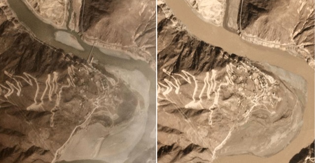
One of my favourite blogs - The Landslide Blog - has three posts about a major landslide on the Jinsha River on the borders of Tibet and Sichuan. The slide blocked the river and a huge lake formed. See HERE.
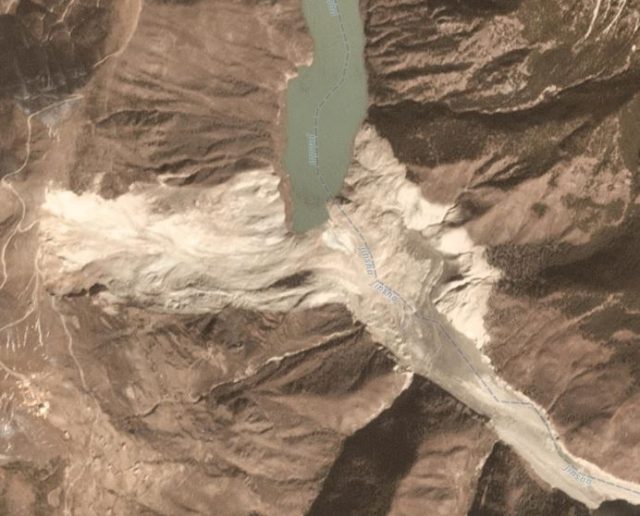
The landslide
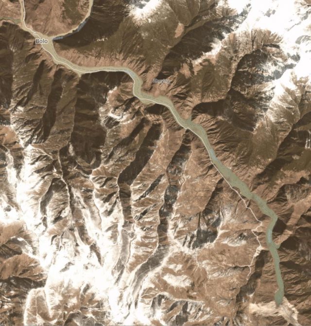
The lake formed
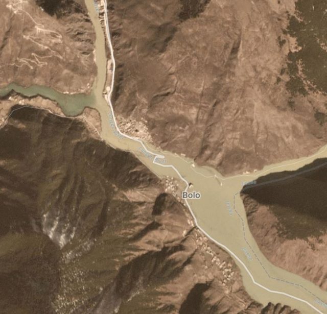
Bolo flooded
Then huge efforts were made to breach the landslide - it looks as if a lot of material was removed. HERE is the blog about that.
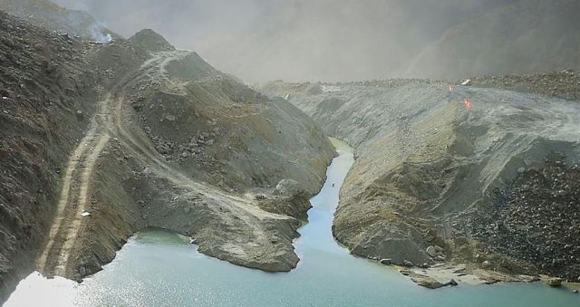
A view from upstream of the Jinsha River landslide showing the lowering of the landslide and the cutting of a breach.
But repairing something like this causes damage. You can read about this HERE. Bridges were destroyed downstream.
Before and after photos of a bridge downstream destroyed by the water released by the breaching. It would have been rather worse if the landslide had been allowed to wash away and the flood to come unexpectedly.
This video shows the power of the water running through the landslide.
Thursday, 15 November 2018
Newly discovered impact crater?
Is there Something Under the Ice?
A source has brought this article from the BBC to my attention. It is based on this article in a scientific journal.
The suggestion is that there is a meteor impact crater under the Greenland Ice Sheet in North West Greenland. I rather like the fact that the Hiawatha Glacier runs over the supposed impact crater.
From various strands of evidence it is suggested that the 31 km wide depression, under almost a km of ice, was created by the impact of a 1.5 km wide iron asteroid sometime between 12,000 and three million years ago. No one has actually seen the crater or identified parts of the asteroid as yet.
There is a suggestion that it is connected with the Cape York meteorite and the Younger Dryas. But much more information needs to be collected before informed speculation can begin. Uninformed speculation is straining at the leash!
There is a suggestion that it is connected with the Cape York meteorite and the Younger Dryas. But much more information needs to be collected before informed speculation can begin. Uninformed speculation is straining at the leash!

Wednesday, 14 November 2018
Visit a fault scarp
Possible Field Trip?
If I ignore that this is in New Zealand, a field trip beckons to look at this fault scarp!

The scarp developed as a result of the magnitude 7.8 earthquake of the 14th November 2016. it is about 3.5m high.
You can get more details and lots more photos HERE
Saturday, 10 November 2018
12th to 18th November 2018
NEXT Weeks EVENTS
12th to 18th November 2018
THE FOLLOWING IS AN EXTRACT FROM BRISTOL AND WEST COUNTRY GEOLOGY CALENDARS
MORE DETAILS CAN BE FOUND IN THE BRISTOL AND THE WEST COUNTRY CALENDARS AND ON THE WEB SITES OF THE RELEVANT SOCIETY OR ORGANISATION.
MONDAY 12TH
Course - Geology of the Bristol and Gloucester Region.
When
Mon, 12 November, 19:30 – 21:30
Where
Wynstones School, Stroud Road, Whaddon, Gloucester (map)
Description
Geology of the Bristol and Gloucester Region.
One of the most varied regions of Britain, spanning the major divisions of the Variscan Front/Bristol Channel-Bray Fault, and the Malvern fault/ Worcester Graben, incorporating rocks varying in age from late PreCambrian to Cretaceous, and three of the terranes making up the geological “jigsaw” of Britain. The course will cover roughly the area covered by the eponymous BGS publication in the British Regional Geology series (3rd edition 1992). Starts Mon 17th September for 10 weeks (not 22nd or29th Oct or 5th Nov), until 10th December Held at Wynstones School, Stroud Road, Whaddon, Gloucester from 7.30-9.30pm on Mondays. Cost £75 (including tea, coffee etc at breaktime!).
Contact Dave Green by email at davegeostudies@gmail.com, by phone at 01594 960858 and by post at Dave Green, Joys Green Farm, Lydbrook, Gloucestershire, GL17 9QU
TUESDAY 13TH
Cardiff University Lecture - When Sea levels Change...
When
Tue, 13 November, 18:30 – 20:00
Where
The 2018-2019 monthly Tuesday evening lectures in the School of Earth and Ocean Sciences will be held in the Wallace Lecture Theatre (0.13), Main Building, Cardiff University, Park Place, CF10 3AT. Lectures begin at 18.30. Booking is not needed. (map)
Description
When water levels change; stories of floods and tsunamis.
Sanjeev Gupta (UCL)
-------------------------------------
WEGA Lecture - Antarctic Glacial Change
When
Tue, 13 November, 19:30 – 21:00
Where
Wills Memorial Building, Bristol BS8 1RL, UK (map)
Description
Lecture by Dr Lucy Clarke (Uni of Glos),
“Unlocking the Archive: Antarctic Glacial Change”
WEDNESDAY 14th
Thursday 15th
Course - Understanding Geology and Scenery around Ross-on-Wye
When
Thu, 15 November, 10:00 – 10:30
Description
Understanding Geology and Scenery around Ross-on-Wye
Starts September 21st (not 25th Oct or 8th Nov), finishes 6th December.
This 10 week course aims to introduce you to the ways in which the varied and beautiful landscape round our area has come into being. The effects of folds, faults and tectonic dip in exposing different rock types, and the past and present processes of uplift, weathering, erosion and deposition that have acted upon them, will be examined by reference to local scenery. Use will be made of local maps and cross-sections across them, both geological and topographic; together with specimens of local rocks. Contact Paul Mason on 01989 760399. Cost £60 Enrol before 15th September to ensure that the course runs.
----------------------------
Thornbury Geology Group, 7.30pm, The Chantry, Thornbury
When
Thu, 15 November, 19:00 – 21:30
Description
Thornbury Geology Group, 7.30pm at The Chantry, Thornbury, and every 3rd Thursday in the month.
Friday 16th
Saturday 17th
DGAG ANNUAL DINNER AT THE WESSEX ROYALE HOTEL
WHEN
SATURDAY, 17 NOV 2018
WHERE
WESSEX ROYALE HOTEL, 32 HIGH WEST STREET, DORCHESTER, DORSET, DT1 1UP, UNITED KINGDOM (MAP)
DESCRIPTION
ANNUAL DINNER AT THE WESSEX ROYALE HOTEL, DORCHESTER. GUEST SPEAKER: ROBERT CHANDLER. MENU AND BOOKING FORM WILL BE IN THE AUTUMN NEWSLETTER
---------------------------
NICK CHIDLAW - GEOLOGICAL WALK
WHEN
SATURDAY, 17 NOV 2018
WHERE
GLOUCESTERSHIRE, UK (MAP)
DESCRIPTION
ICE AGE & HOT DESERT: TWO GEOLOGICAL WALKS NEAR GLOUCESTER (SATURDAY 17TH NOVEMBER)
THE SEVERN VALLEY IMMEDIATELY NORTH OF GLOUCESTER COMPRISES A RURAL LANDSCAPE OF FARMLAND AND SCATTERED VILLAGES, PUNCTUATED BY ABRUPT, FLAT-TOPPED HILLS, AND EXTENSIVE TRACTS OF VALLEY FLOOR OVER WHICH THE TIDAL RIVER FLOWS SOUTH. THE GEOLOGICAL HISTORY OF THE AREA IS FASCINATING AND CONTRASTING. THE OLDEST STRATA, C. 200 MILLION YEARS OLD, ARE VERY GENTLY FOLDED INTO A BASIN STRUCTURE AND WERE LAID DOWN AS HOT DESERTS GAVE WAY TO SHALLOW TROPICAL SEAS IN LATE TRIASSIC / EARLY JURASSIC TIMES. THEY ARE EXPOSED IN CLIFFS ALONG THE RIVER. THE HILL TOPS AND VALLEY SIDES BELOW PRESERVE DEPOSITS LAID DOWN BY A GLACIER AND MELTWATERS DURING THE ICE AGE. AT THIS TIME, THE RIVER PROGRESSIVELY CUT DOWN ITS COURSE, AT ONE TIME REACHING BELOW ITS PRESENT LEVEL. WITH THE ENDING OF THE ICE AGE IN BRITAIN SOME 10,000 YEARS AGO, AND THE ASSOCIATED RISE IN SEA LEVEL, THE RIVER HAS BUILT UP ITS BROAD CLAYEY PLAIN, FREQUENTLY PRONE TO HAZARDOUS WINTER FLOODS. THIS COURSE COMPRISES A MORNING WALK (C. 4 MILES) AND AN AFTERNOON WALK (C. 3 MILES), BOTH GENTLY-PACED WITH FREQUENT STOPS TO DISCUSS THE GEOLOGY AND LANDFORMS.
VOLUNTEER DRIVERS AMONGST THE FIELD PARTY WILL BE REQUIRED TO FACILITATE THE PLANNED WALKING - DO LET ME KNOW WHEN ENROLLING IF YOU CAN HELP IN THIS REGARD.
TUITION FEE IS £27.00 PER PERSON PER COURSE.
IF YOU / ANYONE ELSE YOU KNOW WOULD LIKE TO ATTEND EITHER OR BOTH OF THESE COURSES, PLEASE FORWARD CHEQUE PAYABLE TO ME TO:
DR N CHIDLAW
8 SILVER STREET
DURSLEY,
GLOS.
GL11 4ND
BANK TRANS CAN BE ARRANGED IF YOU DO NOT USE CHEQUES - LET ME KNOW.
PLEASE PROVIDE ME WITH YOUR POSTAL ADDRESS - I WILL THEN BE ABLE TO SEND YOU YOUR COURSE HANDOUT(S) IN GOOD TIME BEFORE THE COURSES RUN, SHOULD THEY BECOME VIABLE.
THE DEADLINE FOR THE MINIMUM NUMBER (10) OF ENROLMENTS FOR BOTH COURSES IS THURSDAY 1ST NOVEMBER (JUST OVER 2 WEEKS BEFORE THE COURSES ARE PROPOSED TO RUN). MAXIMUM NUMBER OF ENROLMENTS IS 30. IF THE MINIMUM OF ENROLMENTS IS REACHED BY THIS DEADLINE, THE ARRANGEMENTS WILL CONTINUE; IF NOT, THE COURSE WILL BE CANCELLED AND FEES RECEIVED WILL BE RETURNED TO THOSE WHO HAVE SENT THEM IN, SOON AFTERWARDS.
PLEASE NOTE THAT FOR EACH COURSE YOU WILL NEED TO:
ARRANGE YOUR OWN TRANSPORT (AND ACCOMMODATION SUCH AS B&B IF YOU LIVE BEYOND REASONABLE COMMUTING DISTANCE - TUTOR CAN ADVISE)
BRING YOUR OWN PACKED LUNCH(ES), AND ANY REFRESHMENTS (E.G. FLASK OF COFFEE, FRUIT JUICE, MINERAL WATER, HIGH ENERGY SNACKS ETC.)
WEAR STRONG FOOTWEAR WITH GOOD TREAD AND ANKLE SUPPORT, AND WARM WATERPROOF CLOTHING IF WEATHER IS POOR
WEAR HARD HATS WHEN BELOW ROCK FACES (BRING ONE, OR REQUEST FROM THE TUTOR IN ADVANCE OF THE COURSE(S) TO BORROW ONE)
YOU WOULD BE INSURED AGAINST ACCIDENT FOR THE DURATION OF BOTH COURSES.
--------------------------------
Sussex Mineral Show.
When
Sat, 17 November, 10:00 – 16:30
Where
Clair Hall, Haywards Heath, RH16 3DN. (map)
Sunday 18th
Nick Chidlaw - Geological Walk
When
Sunday, 18 Nov 2018
Where
Gloucestershire, UK (map)
Description
A GEOLOGICAL WALK IN ESCARPMENT COUNTRY, MID COTSWOLDS: Jurassic strata and landforms near and far (Sunday 18th November)
The steep escarpment of Jurassic rocks in the mid Cotswolds looks north-west across the broad low-lying Severn Vale, to the Welsh Borderland hills and beyond. This mainly rural, highly attractive landscape overlies a geological legacy of repeated tectonic plate collision and extension, uplift and erosion going back to Precambrian times. On this course you can learn to recognise these landforms, know of their underlying rocks, and understand how both came into being. Walking about 4 miles between Doverow Hill near Stonehouse across the valley of the river Frome to Selsley Common, we examine exposures of Early and Middle Jurassic strata in old quarries and pits, and lane cuttings. The Early Jurassic rocks here, mostly soft, muddy and sandy sedimentary deposits, were laid down in warm tropical seas overlying an active rift complex before the North Atlantic Ocean basin opened to the west; the overlying Middle Jurassic strata, mostly limestones with highly fossiliferous beds, were deposited when the seas became shallower and clearer and the crustal rifting died down. In later geological times, the Jurassic strata came under north-south tension, causing the rocks to develop parallel sets of faults running east-west, and displacements to occur. During the Ice Age, the River Severn and its tributaries progressively incised their courses, and landslides occurred on the escarpment as it came into being; these landslides continued to take place, notably at the end of the last cold climatic episode.
Volunteer drivers amongst the field party will be required to facilitate the planned walking - do let me know when enrolling if you can help in this regard.
Tuition fee is £27.00 per person per course.
If you / anyone else you know would like to attend either or both of these courses, please forward cheque payable to me to:
Dr N Chidlaw
8 Silver Street
Dursley,
Glos.
GL11 4ND
Bank trans can be arranged if you do not use cheques - let me know.
Please provide me with your postal address - I will then be able to send you your course handout(s) in good time before the courses run, should they become viable.
The deadline for the minimum number (10) of enrolments for both courses is Thursday 1st November (just over 2 weeks before the courses are proposed to run). Maximum number of enrolments is 30. If the minimum of enrolments is reached by this deadline, the arrangements will continue; if not, the course will be cancelled and fees received will be returned to those who have sent them in, soon afterwards.
Please note that for each course you will need to:
Arrange your own transport (and accommodation such as B&B if you live beyond reasonable commuting distance - tutor can advise)
Bring your own packed lunch(es), and any refreshments (e.g. flask of coffee, fruit juice, mineral water, high energy snacks etc.)
Wear strong footwear with good tread and ankle support, and warm waterproof clothing if weather is poor
Wear hard hats when below rock faces (bring one, or request from the tutor in advance of the course(s) to borrow one)
You would be insured against accident for the duration of both courses.
Course - Geology of the Bristol and Gloucester Region.
When
Mon, 12 November, 19:30 – 21:30
Where
Wynstones School, Stroud Road, Whaddon, Gloucester (map)
Description
Geology of the Bristol and Gloucester Region.
One of the most varied regions of Britain, spanning the major divisions of the Variscan Front/Bristol Channel-Bray Fault, and the Malvern fault/ Worcester Graben, incorporating rocks varying in age from late PreCambrian to Cretaceous, and three of the terranes making up the geological “jigsaw” of Britain. The course will cover roughly the area covered by the eponymous BGS publication in the British Regional Geology series (3rd edition 1992). Starts Mon 17th September for 10 weeks (not 22nd or29th Oct or 5th Nov), until 10th December Held at Wynstones School, Stroud Road, Whaddon, Gloucester from 7.30-9.30pm on Mondays. Cost £75 (including tea, coffee etc at breaktime!).
Contact Dave Green by email at davegeostudies@gmail.com, by phone at 01594 960858 and by post at Dave Green, Joys Green Farm, Lydbrook, Gloucestershire, GL17 9QU
Cardiff University Lecture - When Sea levels Change...
When
Tue, 13 November, 18:30 – 20:00
Where
The 2018-2019 monthly Tuesday evening lectures in the School of Earth and Ocean Sciences will be held in the Wallace Lecture Theatre (0.13), Main Building, Cardiff University, Park Place, CF10 3AT. Lectures begin at 18.30. Booking is not needed. (map)
Description
When water levels change; stories of floods and tsunamis.
Sanjeev Gupta (UCL)
-------------------------------------
WEGA Lecture - Antarctic Glacial Change
When
Tue, 13 November, 19:30 – 21:00
Where
Wills Memorial Building, Bristol BS8 1RL, UK (map)
Description
Lecture by Dr Lucy Clarke (Uni of Glos),
“Unlocking the Archive: Antarctic Glacial Change”
Course - Understanding Geology and Scenery around Ross-on-Wye
When
Thu, 15 November, 10:00 – 10:30
Description
Understanding Geology and Scenery around Ross-on-Wye
Starts September 21st (not 25th Oct or 8th Nov), finishes 6th December.
This 10 week course aims to introduce you to the ways in which the varied and beautiful landscape round our area has come into being. The effects of folds, faults and tectonic dip in exposing different rock types, and the past and present processes of uplift, weathering, erosion and deposition that have acted upon them, will be examined by reference to local scenery. Use will be made of local maps and cross-sections across them, both geological and topographic; together with specimens of local rocks. Contact Paul Mason on 01989 760399. Cost £60 Enrol before 15th September to ensure that the course runs.
----------------------------
Thornbury Geology Group, 7.30pm, The Chantry, Thornbury
When
Thu, 15 November, 19:00 – 21:30
Description
Thornbury Geology Group, 7.30pm at The Chantry, Thornbury, and every 3rd Thursday in the month.
DGAG ANNUAL DINNER AT THE WESSEX ROYALE HOTEL
WHEN
SATURDAY, 17 NOV 2018
WHERE
WESSEX ROYALE HOTEL, 32 HIGH WEST STREET, DORCHESTER, DORSET, DT1 1UP, UNITED KINGDOM (MAP)
DESCRIPTION
ANNUAL DINNER AT THE WESSEX ROYALE HOTEL, DORCHESTER. GUEST SPEAKER: ROBERT CHANDLER. MENU AND BOOKING FORM WILL BE IN THE AUTUMN NEWSLETTER
---------------------------
NICK CHIDLAW - GEOLOGICAL WALK
WHEN
SATURDAY, 17 NOV 2018
WHERE
GLOUCESTERSHIRE, UK (MAP)
DESCRIPTION
ICE AGE & HOT DESERT: TWO GEOLOGICAL WALKS NEAR GLOUCESTER (SATURDAY 17TH NOVEMBER)
THE SEVERN VALLEY IMMEDIATELY NORTH OF GLOUCESTER COMPRISES A RURAL LANDSCAPE OF FARMLAND AND SCATTERED VILLAGES, PUNCTUATED BY ABRUPT, FLAT-TOPPED HILLS, AND EXTENSIVE TRACTS OF VALLEY FLOOR OVER WHICH THE TIDAL RIVER FLOWS SOUTH. THE GEOLOGICAL HISTORY OF THE AREA IS FASCINATING AND CONTRASTING. THE OLDEST STRATA, C. 200 MILLION YEARS OLD, ARE VERY GENTLY FOLDED INTO A BASIN STRUCTURE AND WERE LAID DOWN AS HOT DESERTS GAVE WAY TO SHALLOW TROPICAL SEAS IN LATE TRIASSIC / EARLY JURASSIC TIMES. THEY ARE EXPOSED IN CLIFFS ALONG THE RIVER. THE HILL TOPS AND VALLEY SIDES BELOW PRESERVE DEPOSITS LAID DOWN BY A GLACIER AND MELTWATERS DURING THE ICE AGE. AT THIS TIME, THE RIVER PROGRESSIVELY CUT DOWN ITS COURSE, AT ONE TIME REACHING BELOW ITS PRESENT LEVEL. WITH THE ENDING OF THE ICE AGE IN BRITAIN SOME 10,000 YEARS AGO, AND THE ASSOCIATED RISE IN SEA LEVEL, THE RIVER HAS BUILT UP ITS BROAD CLAYEY PLAIN, FREQUENTLY PRONE TO HAZARDOUS WINTER FLOODS. THIS COURSE COMPRISES A MORNING WALK (C. 4 MILES) AND AN AFTERNOON WALK (C. 3 MILES), BOTH GENTLY-PACED WITH FREQUENT STOPS TO DISCUSS THE GEOLOGY AND LANDFORMS.
VOLUNTEER DRIVERS AMONGST THE FIELD PARTY WILL BE REQUIRED TO FACILITATE THE PLANNED WALKING - DO LET ME KNOW WHEN ENROLLING IF YOU CAN HELP IN THIS REGARD.
TUITION FEE IS £27.00 PER PERSON PER COURSE.
IF YOU / ANYONE ELSE YOU KNOW WOULD LIKE TO ATTEND EITHER OR BOTH OF THESE COURSES, PLEASE FORWARD CHEQUE PAYABLE TO ME TO:
DR N CHIDLAW
8 SILVER STREET
DURSLEY,
GLOS.
GL11 4ND
BANK TRANS CAN BE ARRANGED IF YOU DO NOT USE CHEQUES - LET ME KNOW.
PLEASE PROVIDE ME WITH YOUR POSTAL ADDRESS - I WILL THEN BE ABLE TO SEND YOU YOUR COURSE HANDOUT(S) IN GOOD TIME BEFORE THE COURSES RUN, SHOULD THEY BECOME VIABLE.
THE DEADLINE FOR THE MINIMUM NUMBER (10) OF ENROLMENTS FOR BOTH COURSES IS THURSDAY 1ST NOVEMBER (JUST OVER 2 WEEKS BEFORE THE COURSES ARE PROPOSED TO RUN). MAXIMUM NUMBER OF ENROLMENTS IS 30. IF THE MINIMUM OF ENROLMENTS IS REACHED BY THIS DEADLINE, THE ARRANGEMENTS WILL CONTINUE; IF NOT, THE COURSE WILL BE CANCELLED AND FEES RECEIVED WILL BE RETURNED TO THOSE WHO HAVE SENT THEM IN, SOON AFTERWARDS.
PLEASE NOTE THAT FOR EACH COURSE YOU WILL NEED TO:
ARRANGE YOUR OWN TRANSPORT (AND ACCOMMODATION SUCH AS B&B IF YOU LIVE BEYOND REASONABLE COMMUTING DISTANCE - TUTOR CAN ADVISE)
BRING YOUR OWN PACKED LUNCH(ES), AND ANY REFRESHMENTS (E.G. FLASK OF COFFEE, FRUIT JUICE, MINERAL WATER, HIGH ENERGY SNACKS ETC.)
WEAR STRONG FOOTWEAR WITH GOOD TREAD AND ANKLE SUPPORT, AND WARM WATERPROOF CLOTHING IF WEATHER IS POOR
WEAR HARD HATS WHEN BELOW ROCK FACES (BRING ONE, OR REQUEST FROM THE TUTOR IN ADVANCE OF THE COURSE(S) TO BORROW ONE)
YOU WOULD BE INSURED AGAINST ACCIDENT FOR THE DURATION OF BOTH COURSES.
--------------------------------
Sussex Mineral Show.
When
Sat, 17 November, 10:00 – 16:30
Where
Clair Hall, Haywards Heath, RH16 3DN. (map)
Nick Chidlaw - Geological Walk
When
Sunday, 18 Nov 2018
Where
Gloucestershire, UK (map)
Description
A GEOLOGICAL WALK IN ESCARPMENT COUNTRY, MID COTSWOLDS: Jurassic strata and landforms near and far (Sunday 18th November)
The steep escarpment of Jurassic rocks in the mid Cotswolds looks north-west across the broad low-lying Severn Vale, to the Welsh Borderland hills and beyond. This mainly rural, highly attractive landscape overlies a geological legacy of repeated tectonic plate collision and extension, uplift and erosion going back to Precambrian times. On this course you can learn to recognise these landforms, know of their underlying rocks, and understand how both came into being. Walking about 4 miles between Doverow Hill near Stonehouse across the valley of the river Frome to Selsley Common, we examine exposures of Early and Middle Jurassic strata in old quarries and pits, and lane cuttings. The Early Jurassic rocks here, mostly soft, muddy and sandy sedimentary deposits, were laid down in warm tropical seas overlying an active rift complex before the North Atlantic Ocean basin opened to the west; the overlying Middle Jurassic strata, mostly limestones with highly fossiliferous beds, were deposited when the seas became shallower and clearer and the crustal rifting died down. In later geological times, the Jurassic strata came under north-south tension, causing the rocks to develop parallel sets of faults running east-west, and displacements to occur. During the Ice Age, the River Severn and its tributaries progressively incised their courses, and landslides occurred on the escarpment as it came into being; these landslides continued to take place, notably at the end of the last cold climatic episode.
Volunteer drivers amongst the field party will be required to facilitate the planned walking - do let me know when enrolling if you can help in this regard.
Tuition fee is £27.00 per person per course.
If you / anyone else you know would like to attend either or both of these courses, please forward cheque payable to me to:
Dr N Chidlaw
8 Silver Street
Dursley,
Glos.
GL11 4ND
Bank trans can be arranged if you do not use cheques - let me know.
Please provide me with your postal address - I will then be able to send you your course handout(s) in good time before the courses run, should they become viable.
The deadline for the minimum number (10) of enrolments for both courses is Thursday 1st November (just over 2 weeks before the courses are proposed to run). Maximum number of enrolments is 30. If the minimum of enrolments is reached by this deadline, the arrangements will continue; if not, the course will be cancelled and fees received will be returned to those who have sent them in, soon afterwards.
Please note that for each course you will need to:
Arrange your own transport (and accommodation such as B&B if you live beyond reasonable commuting distance - tutor can advise)
Bring your own packed lunch(es), and any refreshments (e.g. flask of coffee, fruit juice, mineral water, high energy snacks etc.)
Wear strong footwear with good tread and ankle support, and warm waterproof clothing if weather is poor
Wear hard hats when below rock faces (bring one, or request from the tutor in advance of the course(s) to borrow one)
You would be insured against accident for the duration of both courses.
Subscribe to:
Posts (Atom)