Saturday 16 December 2023

The Danger of Melting Permafrost

 The Danger of Melting Permafrost

THIS ARTICLE tells of the dangers of permafrost melting - release of methane. It is based on THIS ACADEMIC PAPER. (The article has less than 650 words, the paper has over 14,000 so the paper is more nuanced than the article.) 

It seems that permafrost acts as a "cap rock" for methane. The research was done in Svalbard where there has been a long history of hydrocarbon exploration. 

The methane has two sources - biogenic - recent sources - and thermogenic - geologic timescales - and both sorts have been sealed from the atmosphere by permafrost.

With global warming permafrost is becoming less permanent and methane is likely to escape into the atmosphere where it is a potent greenhouse gas. The amounts involved are unknown. 

Something else to worry about.

Saturday 9 December 2023

Two New Nick Chidlaw Courses

 Two New Nick Chidlaw Courses

Nick Chidlaw wants to run two courses early next year. The format of the courses is that he sends enrolees a digital document for them to study for two weeks; then follows a week for people to ask Nick questions by email. Then Nick sends everyone the most informative questions and answers.

The courses are:-

A YOUNG OROGENIC BELT: COLLISION OF THE INDIAN TECTONIC PLATE WITH ASIA  
Tutor: Dr Nick Chidlaw 
Reading Period: Monday 15th – Sunday 28th January 2024 (2 weeks)
Dialogue Period:  Monday 29th January – Sunday 4th February 2024 (1 week)
Tuition fee £33.00 per person.
----------------------------------------------------

AN ANCIENT OROGENY: THE GRAMPIAN OROGENIC BELT, NORTHERN SCOTLAND
Tutor: Dr Nick Chidlaw
Reading Period: Monday 5th - Sunday 18th February 2024 (2 weeks)
Dialogue Period:  Monday 19th – Sunday 25th February 2024 (1 week)
Tuition fee £33.00 per person.
--------------------------------------

In both cases the closing date for enrolment is Sunday 7th January.

Nick has prepared a document which has all the details. You can get a copy HERE.

Friday 1 December 2023

Down to Earth Extra December 2023

 Down to Earth Extra December 2023


The December 2023 edition of Down to Earth Extra has been published. You can download it HERE or you can read it below.


Saturday 18 November 2023

Iceland Volcano - A Good YouTube Channel

 Iceland Volcano - A Good YouTube Channel

The recent activity in Iceland has resulted in a multitude of stuff on YouTube. THIS CHANNEL is produced by a geology professor from Idaho who actually has done a lot of work on Icelandic volcanism. He produces a daily report which is very informative. Worth watching!


Saturday 11 November 2023

Down to Earth Extra November 2023

 Down to Earth Extra November 2023

The November 2023 edition of Down to Earth Extra has been published. You can download it HERE or you can read it below.


Icelandic Volcanoes

 Icelandic Volcanoes

Things seem to be happening fast in Iceland. A town (Grindavik) has been evacuated and an eruption is awaited. Unlike recent volcanic events in Iceland, this time there may be significant danger to infrastructure and lives.

The following video explains what is going on.


Has a New Continent Been Found?

Has a New Continent Been Found? 

A correspondent sent me THIS LINK. It tells us about a bit of Australia which moved towards South-East Asia and got split up into fragments on its way. The article includes the following YouTube video. It shows what the authors think happened. All I can say is that it is mighty complicated! (Click the full page symbol to make the video as large as possible. This might make it more comprehensible!)


The amount of evidence collected must be huge. Trying to put it together to make a logical story is beyond my capabilities!

The intriguing thing is that it may explain the Wallace Line - the border between the flora and fauna of South-East Asia and Australia. But the time scales are surely different. The geology talks in terms of hundreds of millions of years, the flora and fauna would be a shorter time scale.


How Do Moons Have Oceans?

 How Do Moons Have Oceans?

A correspondent emailed to tell me that THIS ARTICLE was interesting and deserved to be in the blog. I concur!

The moons in question are some of those of Jupiter and Saturn. We don't know about those around Uranus and Neptune but stay tuned! 

The obvious one is Enceladus, the ice covered moon of Saturn. It has icy plumes erupting near its south pole. A fly through by the Cassini spacecraft found it to be water containing sodium chloride, quartz and hydrogen.

Read the article to find the moons with oceans, but what interests me and the author is how does liquid water exist in what must be a very cold place. The answer seems to be tidal friction. 

In their orbits the moons are subject to gravitational forces from other moon and their parent planet, and these can vary enormously. Bits of the moons are moving against each other producing enough heat to keep their oceans liquid. The outermost parts are frozen, the interior is liquid.

The presence of liquid water leads to speculation about the presence of life - read about it in the article.


Five images of Saturn’s moon Enceladus, seen in infrared light. Nestled beneath its icy shell is a global ocean — a sea that is erupting into space through fractures in the moon’s south pole, coloured red at bottom right.

Thursday 12 October 2023

Two Indoor Courses from Nick Chidlaw

 Two Indoor Courses from Nick Chidlaw

Nick Chidlaw is running two courses this Autumn. Details are below.

-------------------------------------
I am offering to run two 1-day indoor courses in November, if there is enough interest / availability for the courses to go ahead. These courses are repeats of ones I have run in the past, which pleasingly attracted many students; they are based on locations I where I have run field courses.

One of the courses focuses on the diverse sedimentary legacy deposited  and landforms created during the 'Ice Age' within a part of the west of England. Many of these deposits are only occasionally exposed.  The other course focuses on the concept of geological 'terranes', examining evidence for one along the Highland Border in Scotland.  

For both courses, no prior knowledge of geology or the study locations would be assumed. 

The courses may be attractive particularly to people who are not in a position to visit field locations e.g. insufficient time available because of family / work commitments, health difficulties, or who may be interested in the opportunity to study sediments that are no longer extant. 

Each course would comprise powerpoint-based lectures, together with examination of hand specimens of relevant mineral and rock types, and published geological maps of the field areas. The hand specimens have been collected by the tutor in the field areas described. 

The venue is the Buckingham Room (single storey building by the car park) at The Chantry, 52 Castle Street Thornbury, Glos. BS35 1HB. See website www.thechantry.org.uk 
for further details, including location map. On each course, attendees would bring their own packed lunch and other refreshments, or go into the town for lunch. 

These two courses are independent of one-another - you can choose to do either, or both, according to your interests / availability. The courses are £30.00 each.

Viability will be a minimum of 10 enrolments / fee equivalent for each course. 

If you / anybody else you know would like to attend these courses, do get in touch with me nickchidlaw@gmail.com

The viability deadline for both courses is Saturday 4th November. If either or both courses become viable on that date, enrolments will be able to continue until 1 week before the dates the courses are to run. 

If viability is not reached for either or both courses, fee received will be returned soon after to those who have sent them in. 

Any queries, do get in touch. I look forward to hearing from you soon.

Dr Nick Chidlaw

----------------------------------------

Saturday 25th November

'The Ice Age in the Severn Vale and Cotswolds'.  10.00 am - 5.00 pm 

The Quaternary period corresponds to the geological period we are currently living in; it includes what is popularly known as 'The Ice Age', together with the much milder climatic episode that began when the last glaciers in the British Isles disappeared, and which continues to the present day.  The Quaternary period began about 2.6 million years ago, and is divided into two major parts: the Pleistocene epoch (Corresponding to The Ice Age), and the post-glacial Holocene epoch, divided at c. 12,000 years ago. A new epoch, the Anthropocene, during which humans have begun to radically influence geological processes, is being considered. Detailed studies have shown that The Ice Age was in fact composed of cold or glacial conditions alternating with interglacial climates as warm, or warmer, than today, each of these alternations lasting tens of thousands of years. In Britain, as elsewhere, this climatic 'restlessness'  has had dramatic consequences: as ice sheets have grown and retreated, they have changed sea levels, caused extensive erosion of the earth's crust, movement and deposition of the resulting sediments, caused the crust itself to sink and rise, river systems to drastically change their courses as well as downcutting or infilling their valleys, and forced animal and plant life to migrate, leading in some cases to extinction. 

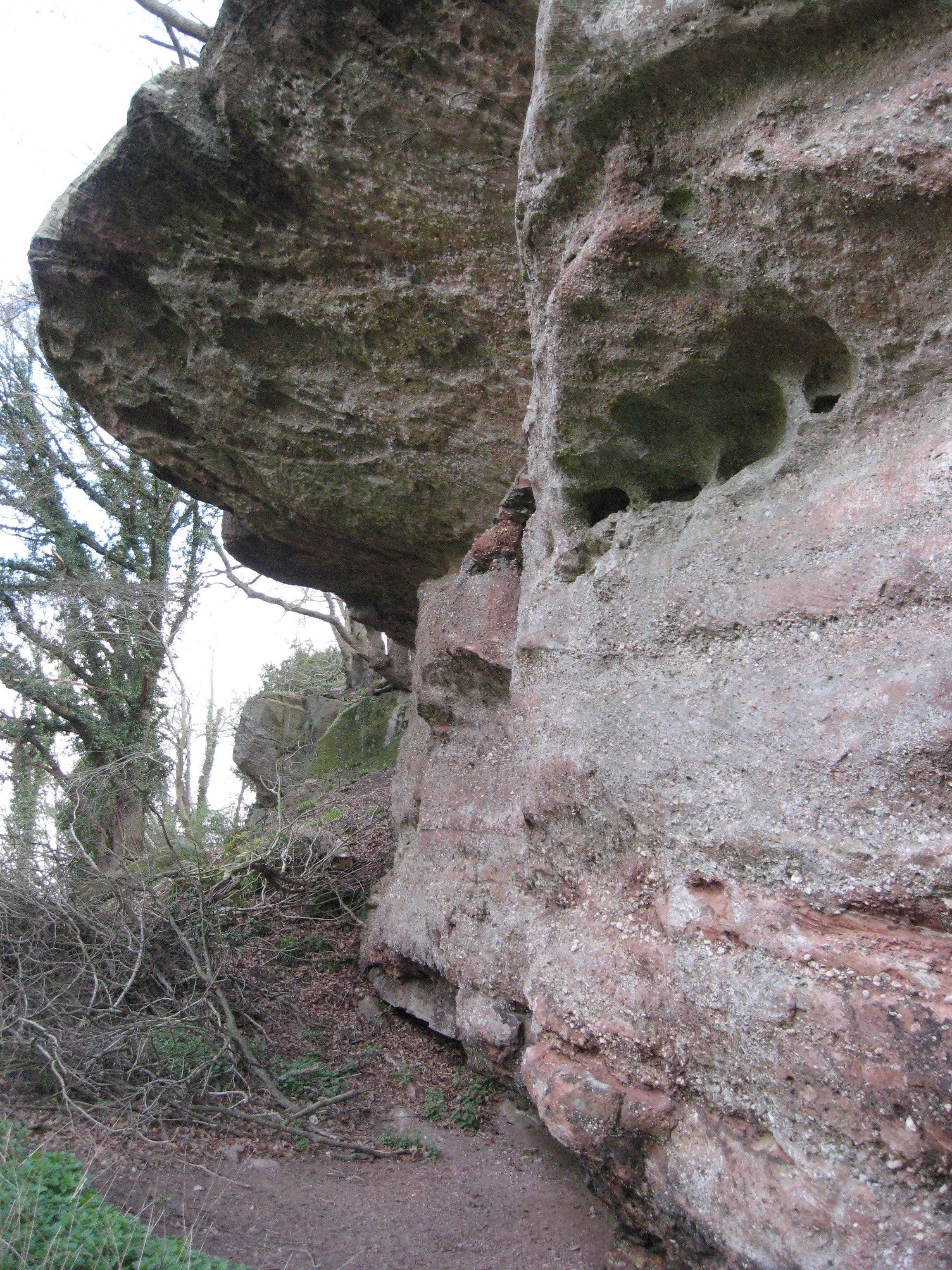
Erosion in the British Isles have been very extensive during the Quaternary, so that deposits laid down since the beginning of the period older than about 600,000 years are very fragmentary. In the uplands such as in Scotland and Wales, repeated glacial action has successively modified landforms and removed older Quaternary sediments, resulting in a limited legacy from which to deduce events. In the lower lands of eastern and southern England, where glaciers reached their maximum extents, the landforms and sediments are better-preserved, and the oldest and most diverse record can be found. The Severn Vale and Cotswolds, lying within this tract, has a great variety of Quaternary landforms and deposits, developed over a wide range of time. 

On this course you will be introduced to these landforms, including anomalous river drainage patterns, dry valleys, river terraces, estuarine platforms and landslides; and deposits laid down by rivers, glaciers, freeze-thaw action, springs, and the Severn Estuary. These deposits are mostly nor normally exposed, but some become temporarily so by human activity e.g for sand and gravel extraction, and ground engineering projects. The tutor has examined a number of these, and their details will be described. Course highlights include the Cotswold scarp being one of the most extensive areas of landsliding in British Isles, and evidence for the Severn Vale not existing prior to the Quaternary. 

A handout outlining the day's programme, and a list of optional suggested reading, would be provided on the course.     


Glacial till overlain by outwash gravels. Anglian Glaciation. Gravel pit exposure (now infilled) near Moreton-in-Marsh, Glos.    

------------------------------------------------------------------

Sunday 26th November

'Highland Border Geology, Scotland; evidence for a terrane boundary' 10.00 am - 5.00 pm 

Many tectonic plate collision zones around the world contain ‘terranes’: regions of crust with well-defined boundaries, that differ significantly in their geological development from neighbouring regions. Ancient long-since stabilised collision zones globally are often composed of a set of interlocking (often fault-bounded) terranes, each of which originated in different places and had different tectonic histories, but which were progressively amalgamated into the  arrangement seen today. The crust of the British Isles is composed of a number of such terranes, brought together by plate collisions that culminated in the ‘Caledonian Orogeny’ (mountain-building episode, Early Silurian – Mid Devonian times). On this course, we trace one of these terrane boundaries along the Highland Border of Scotland between the Isle of Bute (near Glasgow) in the west, to Stonehaven (near Aberdeen) on the east coast. We will look at the character of the two terranes involved, the nature of the boundary between them, evidence for when the terranes were separated, and for when they finally became joined.

A handout outlining the day's programme, and a list of optional suggested reading, would be provided on the course.    


Contrasting landscape along the Highland Border, Scotland: low-lying cultivated land of the Midland Valley in the foreground; the rugged Grampian Mountains in the distance. 


-----------------------------------------------


Thursday 5 October 2023

What Killed the Dinosaurs?

 What Killed the Dinosaurs?

Things are always more complicated than you would like. With the demise of the dinosaurs you chose either the Chicxulub impact or the Deccan traps. If you were being boringly rational you would say both. 

THIS PAPER describes a computer exercise to determine whether the Deccan Traps were sufficient to do the job by themselves. And comes to the conclusion that they could. Of course they say that the coincidental timing of the asteroid did not help the dinosaurs, but they would have died out anyway. (To read the full paper you need to be subscribed.)

If, like me, you do not have a subscription, read THIS ARTICLE, which gives details of the work and reactions to it from both pro-volcano and pro-asteroid camps. Well worth reading!


Wednesday 27 September 2023

Mammals Doomed - in 250 Million Years

 Mammals Doomed - in 250 Million Years

THIS ARTICLE, based on THIS ACADEMIC PAPER, suggests that in 250 million years a new supercontinent - Pangea Ultima - will form and as a consequence of this CO₂
in the atmosphere will rise. The resulting temperature rise will be sufficient to make mammalian life impossible. There might be hope for burrowing nocturnal rodents living near the poles. (The diagrams indicate that the UK might be a good place if you are a burrowing nocturnal rodent.)

The authors (the main one is Bristol based) provide lots of data and discussion, particularly about why CO₂ should rise. Read it for yourself and see if you agree.

Whether there will be humans around in 250 million years to observe mammalian doom is doubtful. I think we will be long gone by then, seen off by evolution or our stupidity. But, being human, we live to speculate.


The habitable Earth in 250 million years - maybe.


Down to Earth Extra October 2023

 Down to Earth Extra October 2023

The October 2023 edition of Down to Earth Extra has been published. You can download it HERE or you can read it below.


Saturday 23 September 2023

It Happened 8 Thousand Years Ago...

 It Happened 8 Thousand Years Ago...

About 8 thousand years ago things got a lot cooler - 3.3°C cooler. It got cooler because the surface waters of the North Atlantic became fresher - and less heavy.

Because they are less dense they cannot sink. If they don't sink warmer waters cannot come northwards to replace them. And so northern Europe suffers from a cold Atlantic and temperatures drop. And you get a drought. The technical term for this is "a perturbation of the Atlantic Meridional Overturning Circulation (AMOC)".

The cause, 8 thousand years ago, is thought to be the draining of Lake Agassiz in central Canada. Measurements made in the Ythan estuary just north of Aberdeen show sea level rising 2.4 m at 13mm per year around 8.5 thousand years ago.

Worryingly, the same thing is happening now, but with a different cause. The Greenland is cap is melting. It rained on the top of the ice cap (3.2km in elevation) in 2021 for the first time ever!

At first sight the fall in temperature because of global warming might seem to be a good thing. But I doubt it. Adding chaos to chaos is seldom beneficial.

Read all about this in THIS ARTICLE.

Thursday 14 September 2023

Was the PETM Linked to Hydrothermal Venting?

Was the PETM Linked to Hydrothermal Venting? 

The PETM (Palaeocene-Eocene Thermal Maximum) was a period of rapid global warming. Sea surface temperatures rose 6°C within 10 to 20 thousand years. This rate of temperature rise is not very different to what is happening currently. As THIS ARTICLE says, the temperature rise led to the release of organic carbon into the atmosphere. Expressed as CO₂, 0.24 gigatons (Gt) per year. Currently we release 0.51Gt per year. The article is based on THIS PDF.

In the PETM the temperature rise led to the most dramatic biologic changes since the asteroid killed the dinosaurs.

What was the cause? At the time there was magmatic activity around the area which was to become the Atlantic. This was the start of continental rifting. Much of the activity was the intrusion of sills. Could the sills have led to the release of methane from organic rich sediments?

The article suggests that is what happened. Using a 3-D seismic survey they found pockmarks beneath the P-E boundary. Detailed study suggests they formed from hydrothermal venting. 

Because they happened in shallow water the CH₄ went straight into the atmosphere. (At depth it would have been mitigated by the methane being oxidised to carbon dioxide.)


Three-dimensional view of seismic reflection data off western Norway. The greytone lower part is a vertical ‘slice’. The coloured part shows the depth variation of sediments that fill hydrothermal vent systems beneath a horizontal unconformity. (Credit: Berndt et al, Fig 1b)

Early Life and Stromatolites

 Early Life and Stromatolites

I came across THIS PODCAST from GEOLOGY BITES and thought it was very interesting and very approachable. It concerns recent discoveries which prove (probably) that early stromatolites (3.48 Ga) are of organic origin. No one questions the organic origin of current and more recent stromatolites, but these ones are very old!


To get the most from the podcast scroll down THIS PAGE to see the astonishing photos.

I have a slight personal interest in this as we used the interviewee's guide book when we were in Marble Bar, Western Australia in 2013.


And here is my photo of some stromatolitic limestone from the area

Thursday 7 September 2023

Do Plants Evolve Continuously Or In a Big Bang?

 Do Plants Evolve Continuously Or In a Big Bang?

In THIS ARTICLE the authors (many of whom are based in Bristol) explore the hypothesis that, like animals, plants have a higher capacity for innovation early on but later, not so much. The article is based on THIS PAPER in Nature. 

To do this they collected 548 traits of 400 living and fossil plants and plotted the 130,000 observations onto, what they call, a design space. Also on this design space, they plot the predicted traits of extinct shared ancestors.

Then it gets complicated - at least for me - and they produce diagrams such as the one below which have axes which I find difficult to contemplate. I think I know what they mean, but don't ask me to explain it! The Nature article excels in producing even more challenging diagrams. I am sure there is a logical explanation of what NMDS1 and NMDS2 is but I do not know what it is.

Correction - NMDS is "non-metric multidimensional scaling".


The two axes summarise the variation in anatomical design among plants. Coloured dots represent living groups while the black dots represent extinct groups known only from fossils. The lines connecting these groupings represent the evolutionary relationships among living and fossil groups, plus their ancestors, inferred from evolutionary modelling. (The chlorophytes and charophytes are marine and freshwater plants while the remaining groups are land plants. Angiosperms are flowering plants). Philip Donoghue et al / Nature Plants

The result of all this impressive data gathering and analysis is that plants have evolved continuously and not in an early "big bang". And the Animal Kingdom is no different.


Wednesday 30 August 2023

Down to Earth Extra September 2023

  Down to Earth Extra September 2023

The September 2023 edition of Down to Earth Extra has been published. You can download it HERE or you can read it below.


Friday 25 August 2023

Geological Sites of the Bristol Region - back in print!

Geological Sites of the Bristol Region - back in print! 


The revised edition of this book is back in print and is now available from Bristol Museums - £19.50 plus postage. It is described as:-


An accessible introduction to the geology of the region, including the work of many local experts.

The Avon area is highly regarded as one of the more complex geological areas of the country and also contains such iconic sites as the Avon Gorge. The book aims to promote the gathered records that underpin the designation of RIGS. The book is a not a ‘geology book’ per se and doesn’t attempt to be exhaustive, however, it aims to showcase some of the RIGS themselves alongside the people and organisations involved in their conservation. There are several chapters
dedicated to the history of geology and geomorphology in our area and important figures such as William Smith.

The main part of the book is about the sites and modern interpretation of the geological and geomorphological features. Each site’s account includes location and geological maps as well as site descriptions and photographs. There is colour throughout with photographs, graphics and artworks. The book is interspersed with ‘box topics’ of general interest.

ISBN: 9780954523534
Every purchase you make helps to support Bristol Museums, so thanks for shopping with us!

Wednesday 23 August 2023

Mendip Rocks - Read All About It!

 Mendip Rocks - Read All About It!

Simon Carpenter asked me to publicise Mendip Rocks 2023 and I am only too happy to oblige. 

There is an advert which you can get HERE, or read it below. There is also a booklet which you can get HERE, or read it below. 

First the advert.


And now the booklet.


Thursday 17 August 2023

GEOconservationNEWSletter Summer 2023

GEOconservationNEWSletter Summer 2023 

You can get the latest edition of Geo Conservation Newsletter HERE, or you can read it below.


Friday 11 August 2023

Cliff Collapse in Dorset.

 Cliff Collapse in Dorset.

A correspondent has sent me links to news about recent cliff collapses in Dorset.

The first is HERE and below.


And the second HERE and below.


Geologic processes in action - spectacular and normal. Best watched from a distance and examined when all activity has stopped.

Many thanks for the links.

Thursday 10 August 2023

Rain Keeps Earthquakes Away - Sometimes, in Some Places

 Rain Keeps Earthquakes Away - Sometimes, in Some Places

In the Himalayas, most earthquakes (and there are a lot!) occur in the dry season, a lot less happen during the monsoon. The rain (up to 4 metres) compresses the crust both vertically and horizontally, making it more stable. Climate change may make this phenomenon more pronounced.

The same thinking applies to ice. When glaciers melt the loss of weight leads to decompression melting. At present this is noticed only in Iceland - some volcanoes erupt mostly in Summer.

You can read all about it in THIS ARTICLE.  

Monday 7 August 2023

Will "Our" Mammoths be Exported?

 Will "Our" Mammoths be Exported?

I am not the only one to spot THIS ARTICLE in The Guardian. It concerns the recent find of Palaeolithic fossils in a gravel quarry in the Cotswolds. The headline fossils were mammoth bones but much else was found and is suspected to be awaiting discovery. Tools made by Neanderthals were also found.

At first the quarry owners were welcoming and the BBC and David Attenborough made a documentary about the discoveries. But something has changed and the quarry owners want their fossils back!

The suspicion is that the quarriers had a better offer from the UAE who are building a new Natural History Museum in Abu Dhabi and are collecting specimens for it.

Should one oppose this? The British Museum would be a lot emptier if objects could not be exported from where they were found. Indeed many countries want there objects back. 

Does this apply to fossils? If you are a palaeontologist aching to getting your hands on good specimens the answer is obvious - keep the fossils local to me! We can keep cultural objects in Britain but does a British Mammoth have as much culture as a Leonardo Cartoon?

But I would rather see a mammoth in Bristol Museum or even London, rather than flying to Abu Dhabi to see it.


Thursday 3 August 2023

How Old Can an Impact Crater Get?

How Old Can an Impact Crater Get? 

Impact craters are assumed to have been formed in the earliest days of planet Earth but few very old craters are known. THIS ARTICLE uses the Vredefort Dome in South Africa as a means of determining what to look for when finding old, deeply eroded, impact craters.

The Dome is very large (300km across) and very old (2 billion years). The researchers drilled across and around the dome to see if they could spot the effects a large astrobleme can be predicted to make. They could - but only just. There is thought to have been about 7 to 10 km of erosion. 10km would remove all evidence. 

The Vredefort Dome is recognised because of its shape - the central peaks, especially - and the results of shock metamorphism. Another kilometre of erosion would remove these also, leaving no trace of the impact.

The basis of the article is THIS ACADEMIC PAPER.


Gravity map of the Kaapvaal Craton. The Vredefort structure does not have a prominent gravity high or low compared to the surrounding craton. Data from the South African Council for Geoscience. Craton boundary from Hasterok et al. (2022).

Cambrian Jellyfish Fossils!!!

Cambrian Jellyfish Fossils!!! 

If you write a blog like this you seldom expect to write the words jellyfish and fossils in close proximity. To write "Cambrian Jellyfish Fossils" as a thing would have been an impossible dream. But it is the Burgess Shale so anything is possible. 

I was directed to THIS PAPER by a correspondent. It is based on THIS ACADEMIC ARTICLE published by the Royal Society. As mentioned above the fossils come from the Burgess Shale and from the collection of the Royal Ontario Museum.

Jellyfish are, as the name implies, soft bodied, and are extremely unlikely to be fossilised. But the Burgess Shale is very good at preserving soft bodies the illustration shows the results.


Size variations and general morpho-anatomical details of Burgessomedusa phasmiformis gen. et sp. nov. (a) Holotype ROMIP65781.1 (close-up in figure 2a). (b) ROMIP65782.2–3, with putative gonads (close-up in figure 2b). (c), ROMIP65783.1, with putative gonads. (d) ROMIP65784, with putative stomach cavity. e,f, specimens with putative gonads ROMIP65785 (e), ROMIP65786 (f). (g) ROMIP65787, with a contracted umbrella. (h) ROMIP65788, with putative gonads (close-up in figure 2e). (i) ROMIP65114.1–3. (j) ROMIP65789. (k) ROMIP65790.1–2. Abbreviations: bm, bell margin; go, gonads; man, manubrium; st, stomach cavity; ten, tentacles. Scale = 2 cm.


Morphological details of Burgessomedusa phasmiformis gen. et sp. nov. (a) Close-up of stomach cavity, manubrium, and gonads, ROMIP65781.1. (b) Close-up of tentacles ROMIP65782.2. (c,d) specimen showing disarticulated tentacles (close up in d), ROMIP65791. (e) Close-up of tentacles showing equidistant interspaces, ROMIP65788. (f,g) ROMIP65792, with short tentacles (close up in g) placed under the oral umbrella margin. (h,i), ROMIP65793, with tentacle remnants (close up in i). (j) ROMIP65794, specimen with irregular umbrella margin. (k) ROMIP65795.1, specimen showing tetraradial symmetry. All abbreviations are as in figure 1. Scales = 1 cm.

This discovery has generated a lot of interest and you may have seen it referenced in various newspapers.


Saturday 29 July 2023

Lightless Life

Lightless Life 

A correspondent brought THIS ARTICLE to my attention. It is based on THIS ACADEMIC PAPER.

Deep underground, abundant microbes produce oxygen in the absence of light - something which was once thought to be impossible. 

This discovery was made while looking at deep aquifers in Alberta, Canada. These have long been studied as they are essential to agriculture in the province. Much was known of their composition, nothing of their microbiology.

And what was found was that some bacteria split nitrites to produce oxygen.

It is estimated that there is more microbes below ground than on the surface!

Lots more in both articles - well worth a read.


Icelandic Eruption - Continued

 Icelandic Eruption - Continued

A correspondent told me about THIS YOU TUBE CHANNEL - it has some very good content about the current eruption.

Below is a sample.


Down to Earth Extra August 2023

 Down to Earth Extra August 2023


The August 2023 edition of Down to Earth Extra has been published. You can download it HERE or you can read it below.


Friday 21 July 2023

A Geologic Quiz from the BBC

A Geologic Quiz from the BBC 

A correspondent brought THIS QUIZ to my attention. And now I bring it to yours. 

I managed to do quite well - I got the Aberdeen one OK!

Saturday 15 July 2023

Earth Heritage 59

Earth Heritage 59 

You can download Earth Heritage 59 HERE, or read it below.


Saturday 8 July 2023

Two 1-Day Field Course with Nick Chidlaw

Two 1-Day Field Courses with Nick Chidlaw 

Nick Chidlaw has asked me publicise two field courses he will be running in September. These are independent of one another: enrollees can choose to do both or either, according to their availability / interests. Together, the courses examine exposures in most of the stratigraphic Formations of the Old Red Sandstone Supergroup in the area.

-----------------------------------------
 OLD RED SANDSTONE LOCATIONS IN THE SOUTHERN WELSH BORDERLAND: tropical arid-climate river deposits exposed by ice age and post-ice age processes; north east Black Mountains 

Saturday 9th September 10.00 am - 5.00 pm

The Old Red Sandstone Supergroup is found in many parts of the British Isles, and mostly represents the deposition of sediment eroded off mountains and uplands elevated during the Caledonian and Acadian Orogenies, in the Silurian and Devonian periods respectively. The British crust at these times was located in the southern tropics and had a hot arid-semi-arid climate with rainy and dry seasons. The sediment was transported by river systems and deposited across lowlands in channels, flood plains and lakes. 

The strata to be examined on this course includes the Freshwater West Formation and the Senni Formation, of Early Devonian age. They are exposed in small natural crags and big landslide scars on the NE margin of the Black Mountains, in Herefordshire. They represent a change over time from slower sinuous meandering rivers with extensive muddy floodplains to faster-flowing rivers with straighter courses and fewer muddy deposits. This progression of increasing energy continues with the younger Brownstones Formation, which can be seen in the higher parts of the Black Mountains further west or, more conveniently, at Ross-on-Wye (see 10th September course details below). The muddy sediments in the Freshwater West and Senni Formations contain developments of limestone nodules recognised as fossil soils. Fragmentary remains of fish and plants may be found in some of the the channel deposits. 

No previous knowledge of geology or the area will be assumed.   
 

Tuition fee: £30.00 


Contact tutor Dr Nick Chidlaw nickchidlaw@gmail.com to enrol and for any queries. 


Deadline for course viability: Saturday 12th August . If the course has become viable (minimum of 10 enrolments) by this date, enrolments will be able to continue until 1 week before the course runs (Saturday 2nd September ).   


Google Earth image of the study area in the north-east Black Mountains. The narrow ridge on the right of the image is known as the 'Cat's Back'  and provides accessible footpath exposures in the uppermost part of the Freshwater West Formation and the lower part of the Senni Formation. These strata are also exposed in the big landslide scars on the left of the image at 'Red Daren' and 'Black Darren'. 

-----------------------------------


OLD RED SANDSTONE LOCATIONS IN THE SOUTHERN WELSH BORDERLAND: tropical arid-climate river deposits exposed by ice age and post-ice age processes; Ross-on-Wye and near Symonds Yat 


Sunday 10th September 10.00 am - 5.00 pm


The Old Red Sandstone Supergroup is found in many parts of the British Isles, and mostly represents the deposition of sediment eroded off mountains and uplands elevated during the Caledonian and Acadian Orogenies, in the Silurian and Devonian periods respectively. The British crust at these times was located in the southern tropics and had a hot arid-semi-arid climate with rainy and dry seasons. The sediment was transported by river systems and deposited across lowlands in channels, flood plains and lakes. 


The strata to be examined on this course includes the Brownstones Formation (Early Devonian age), and the Huntsham Hill Conglomerate Formation and Tintern Sandstone Formation (Late Devonian - earliest Carboniferous age). The Brownstones are exposed in a large road cutting and natural crags near the River Wye at the town of Ross, and the younger strata in extensive natural crags on the edge of the Forest of Dean near Symonds Yat. The Brownstones represent higher energy river systems than of those strata studied on the Black Mountains course. The late Devonian - earliest Carboniferous strata were deposited after the Acadian Orogeny (Mid Devonian times) and record a progression of decreasing energy river systems as uplands created during the Orogeny were progressively eroded down. 


No previous knowledge of geology or the area will be assumed.   


Tuition fee: £30.00 


Contact tutor Dr Nick Chidlaw nickchidlaw@gmail.com to enrol and for any queries. 


Deadline for course viability: Saturday 12th August . If the course has become viable (minimum of 10 enrolments) by this date, enrolments will be able to continue until 1 week before the course runs (Sunday 3rd September).   


Extensive exposure of the Brownstones Formation: road cutting at Wilton Bluff, Ross-on-Wye. This exposure (c. 5m high) is to be examined from a distance, then close-up examination of the strata will be done in accessible natural crag exposures to the SW. 


Exposure of the Huntsham Hill Conglomerate Formation next to a public footpath on the NW side of Huntsham Hill, near Symonds Yat. The crag is 6-7m high and was formed by periglacial frost action during the last glaciation. 


Exposures of the Tintern Sandstone Formation. Extensive periglacial crags on the E side of narrow, steep ridge forming the S side of Huntsham Hill. The nearest exposure is c. 4-5m high. 


--------------------------------------


Britain Gets Earthquakes, Ireland Doesn't - Why?

Britain Gets Earthquakes, Ireland Doesn't - Why? 

Intriguing fact in the heading above. The illustration below shows the evidence - on the left - and the reason - on the right. This come from THIS ARTICLE and gives rise to an important observation - Moderate variations in plate thickness, occurring far from plate boundaries, can influence patterns of seismic activity within those regions.

The fact that the island of Great Britain has more earthquakes than the island of Ireland has long been known. The cause has only recently come to our understanding. And it is seismic tomography which has given us the answers. The part of the tectonic plate below Ireland (and the eastern side of Great Britain) is thicker (95 - 115km) than that below western Britain (75 - 85km). 

The parent article is HERE but you need to pay for access. I suspect that the simple numbers for thickness I give above are the result of a great deal of work. This only adds to their interest.


Friday 7 July 2023

Down to Earth Extra July 2023

 Down to Earth Extra July 2023

The July 2023 edition of Down to Earth Extra has been published. You can download it HERE or you can read it below.


Tuesday 4 July 2023

When was the First (Placental) Mammal?

 When was the First (Placental) Mammal?

There are three sorts of mammals: monotremes (platypuses), marsupials (kangaroos) and placentals (us and lots more).

How do you find the first placental mammal? I suppose you could find its fossil, be able to determine it is placental, date it, and (the difficult bit) prove that there are none which came before. This is unlikely and your conclusions are likely to be challenged. 

However there are a few fossils which are accepted as being placental mammals dated as living after the extinction of the dinosaurs. But were they the first? Were there placentals living alongside the dinosaurs? There are no accepted placental fossils in rocks below the K-Pg boundary, but that does not prove much.

There is another way, using molecular clocks. Much has been written about the use of molecular clocks - the more you get into it the more difficulties appear. See the diagram below to get a flavour of the controversies.


Thick purple lines are crown orders, green lines are stem orders, and black lines are stem placental families.
(A) Explosive model: all placental mammal diversification and origination occurred just after the K-Pg boundary.
(B) Soft explosive model: placental mammals originated just before the K-Pg boundary, but intraordinal diversification only occurred after the boundary.
(C) Trans-KPg model: both interordinal and intraordinal diversification occurred around the K-Pg boundary.
(D) Long fuse model: placental mammals originated in the middle of Late Cretaceous, but intraordinal diversification did not begin until after the K-Pg boundary.
(E) Short fuse model: placental origination and crown order diversification occurred during the Cretaceous.


The author of THIS ARTICLE, working at Bristol University, has avoided much of these controversies by comparing families and using statistical methods, of which I know little, to conclude that placental mammals originated in the Cretaceous

The article is based on THIS ACADEMIC PAPER. An indication of the depth of study used in the article can be gauged from the following figure.


Clade age and extinction time estimates for placental mammal families

Each line represents a family (arranged by order and clade but without further phylogenetic information), with 95% credible intervals in colors at the root estimates and extinction estimates (where applicable). Gray lines fill in the lineage. 93 families have credible intervals extending into the Cretaceous, but many originated after the K-Pg boundary. For stem and crown order classifications for each family, see Data S1.