Visit the Holm Islands
Dr. Nick Chidlaw has proposed a trip to Steep Holm and Flat Holm. He has written an extensive introduction to the trip which I have repeated below. It sounds rather good.
-------------------------------------
Dear All,
I am currently proposing a trip to study during 1 day the geology of the Holm Islands; these are located in the sea where the Severn Estuary and Bristol Channel meet.
There are 2 islands, Steep Holm and Flat Holm, the former being part of England, and the latter Wales.
I have run trips to study the geology there in the past, and they have enrolled well and attendees have greatly enjoyed visiting the islands and studying the geology. I have also run indoor courses and given talks on the subject, and they have gratifyingly drawn good responses too.
The plan is to duplicate as far as practical the field programme used on earlier trips. This involves landing on Flat Holm, and studying the geology in beach sections and local crags, and sailing around Steep Holm, observing the geology from close inshore but not landing. This plan for Steep Holm is because most of the geology is best observed in its steep cliffs around the island; when on Steep Holm itself, much of this geology is not saffely accessible. The sailing around Steep Holm is not done quickly - we spend over an hour going around, with many stops during which we discuss the geology visible at each key point.
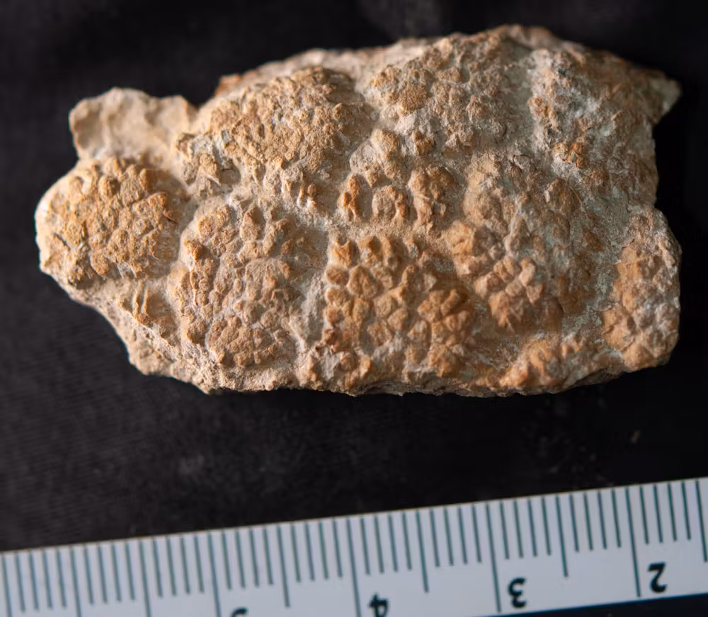
The rocks on both islands are of early Carboniferous age, mostly shallow marine with some indicating episodic emergence. The lithologies are limestones and dolostones with variations in grain size and shelly fossil content, and minor non-carbonate mudrocks. On Flat Holm is a limestone unit known only from that island. Many of the stratigraphic units can be linked to the nearby mainlands of England at Weston-Super-Mare, and in the Barry area in Wales. The strata are extensively deformed by compressional folding and faulting that occurred during the Variscan Orogeny around the end of Carboniferous times c. 300 million years ago: on Steep Holm, the strata mostly dip gently to the S, but become steely-inclined, in places 70 degrees, on its northern side; on Flat Holm, the island is mostly occupies a gentle upfold, plunging to the south west. There are reverse faults observable on Flat Holm together with minor folds superimposed on the main fold, and some impressive ripple structures in the limestone unique to Flat Holm. During the Triassic period, under a hot dry climate, the two islands formed 'inselbergs' surrounded by extensive flats that episodically became lakes. Crustal stretching during the Middle Jurassic c. 170 million years ago carried metalliferous brines up opening faults on Steep Holm, locally depositing galena and baryte. Before the end of the last glacial, c. 12,000 years ago, the sea was much further to the west, and the islands formed hils, between which the River Severn flowed in a narrow ravine some 45m below present sea level. With the ending of the last glacial, sea level rose to form the Bristol Channel and Severn Estuary, leaving the Holms as the islands we see today.
Date of the proposed trip
Saturday 30th August
Transport & organisation
Rigid Inflatable Boat (RIB) operated by Bay Island Voyages Ltd out of Cardiff Bay. It is to be appreciated that if the sea conditons on the day are unsuitable, the company will decide to cancel / postpone the trip for reasons of safety.
Timings
The Bristol Channel and Severn Estuary have some of the highest tidal ranges in the world; as can be appreciated, the proposed itinerary is strongly governed by predicted tidal conditions and currents. On this proposed date, the activities take place from 8 am, with the field party returned to Cardiff Bay by 2 pm.
The details are as follows :
0800 Meet at Cardiff Bay (check in, safety briefing, life jacket fitting.
0830 RIB passes out through Cardiff Bay Barrage
0850 Arrive at Flat Holm. Landing fee £5.00 per person (cash only, payable on arrival). We are allowed c. 2.5 hours on the island
1120 Depart Flat Holm
c.1145 Arrive Steep Holm - circumnavigate island, with frequent pauses, for c. 1.5 hours.
1315 Depart Steep Holm
1345 Pass through Cardiff Bay Barrage
1400 Arrive Cardiff Bay
Fee
The fee involves payment to Bay Island Voyages Ltd for providing private charter transport, and tuition by myself.
I will pay Bay Island Voyages their fee, from fees received from those who are interested and available to attend the trip.
There are 12 places available on the RIB, 11 trip attendees and myself.
The fee per person £125.00
In case there is a good number of people interested and available, enrolments will need to be on a first-come first-served basis.
If there are fewer than 11 who can attend the trip, the cost is likely to be too high per person if the private charter fee is shared between those who can attend; we will need to cancel the proposal should this be the case.
If there are more than 11 who are interested and available to attend the trip, they can be put on a waiting list and Bay Island Voyages Ltd have said there may be another RIB available, but they do not know at the present time.
If the trip can go ahead, I will sent a PDF of the trip document to all those enrolled in good time before the date of the trip. This will provide all logistical information attendees will need (including location of Bay Island Voyages car parking area and embarkation point) plus geological background. Attendees would bring printouts of the trip document with them for reference during the days programme.
Viability Deadline
Bay Island Voyages Ltd has a busy programme, but they are helpfully prepared to operate a provisional booking with us for 2 weeks up to 14th July.
I must therefore make a definite booking with them, and pay their fee, by this set date. If the payment and booking is not secured by that date, they will make the RIB avaiable to other potential users for 30th August.
Payment to me
If you are interested and available for this trip, please forward me your fee of £125.00 by Saturday 12th July.
I will let you know on Saturday 12th July if we can put the trip on. If we do not have enough enrolments, I will return your fee the same day.
Please note enrolment requests are to be sent to:
Some images are given below to illustrate the islands and the transporting vessel used.
I hope you find this proposal interesting and that you can attend. Any queries you may have, do let me know.


Flat Holm

Steep Holm

Holm Islands RIB
-----------------------------------------------