Saturday 29 July 2017

Next week 31st July to 6th August 2017

NEXT WEEKS EVENTS

 31st July to 6th August 2017

The following is an extract from Bristol Geology Calendar

More details can be found in the Calendar and on the web sites of the relevant Society or organisation.


Monday

18:00
 Teme Valley Geol Soc - Geological Amble
WhenMon, 31 July, 18:00 – 21:00
WhereMartley Memorial Hall B4197 by Sports Ground (map)
DescriptionA series of 6 weekly Geo-Ambles with John Nicklin Contact 01886 888318


Tuesday


Wednesday


Thursday


Friday


Saturday


Sunday


Sea Dragons of Somerset

Ichthyosaurs on Display in Street


It may come as a surprise to many that there is nationally important collection of ichthyosaurs in Street. The fossils were found (or acquired by) Alfred Gillett, a cousin of the Clark (the shoemakers) family.

The details of where and when are given above, details of the collection are HERE, and much more can be found HERE

Human origins - evidence continues to accrue

Do we have Neanderthal Mitochondrial DNA?

An article in the Guardian presents evidence from a Neanderthal femur found in 1937 in the Hohlenstein Stadel cave in South West Germany. 

One day we will have a clear picture concerning human origins. At the moment we do not and this article goes through various possibilities in a well informed way. At the moment large hypotheses are being built on tiny amounts of information. But how else do we know what questions to ask?

The Hohlenstein Stadel cave, north of Langenau, Germany

Saturday 8 July 2017

Next 3 weeks 10th to 30th July 2017

NEXT 3 WEEKS EVENTS

 10th to 30th July 2017

The following is an extract from Bristol Geology Calendar

More details can be found in the Calendar and on the web sites of the relevant Society or organisation.


Monday 10th

19:30
 Dave Green's Geology of the Oceans
WhenMon, 10 July, 19:30 – 21:30
WhereWynstones School, Stroud Road, Whaddon, Gloucester (map)
DescriptionThe Geology of the Oceans past and present (including plate tectonics, environments, and current/developing ideas on oceanography and marine geology). Often termed the last frontier to be explored on Earth, there have been great advances in our understanding of the oceanic realm over the past half century. This course aims to study the main developments and what we might expect in the future, based on current research. Monday 24th April, for 10 weeks, until 10th July (not 1st nor 29th May). Held at Wynstones School, Stroud Road, Whaddon, Gloucester from 7.30-9.30pm on Mondays. Cost £70.


Tuesday

19:00
 Dave Green's Geology and Landscape in Gloucestershire
WhenTue, 11 July, 19:00 – 21:00
WhereSee website, separate leaflet, and/or by contacting Dave Green. (map)
Description Penyard Park, the Coughton Meander, and the strange Weston “hollows” Penyard Park represents the furthest extent northwards of the outcrop of the Quartz Conglomerate, the extremely resistant rock that forms the outer ramparts of the Forest of Dean. It has been isolated from the main outcrop (on Howle Hill) by a large valley with a strangely small “misfit” stream (the Coughton Valley)which is thought to be one part of a large meander of the River Wye, now abandoned like a huge ox-bow.We will climb to the top of the hill to see the evidence for this, and the reason for the existence of the hill. Meet at the rough (Church) car park just to the east of the Church in Weston under Penyard SO 632 232


Wednesday


Thursday


Friday

19:00
 Cheltenham MGS Lecture - Minerals of the Malvern Hills
WhenFri, 14 July, 19:00 – 21:00
WhereShurdington at The Century Hall (map)
DescriptionAdrian Wyatt Minerals of the Malvern Hills


Saturday


Sunday

OUGS Wessex - Day Trip "Climate and environmental change in the Cretaceous"
WhenSunday, 16 Jul 2017
WhereWorbarrow Bay, Dorset (map)
DescriptionClimate and environmental change in the Cretaceous - Jeremy Cranmer An opportunity to see evidence of climate and environmental change in the Cretaceous at Worbarrow Bay, Dorset Jeremy Cranmer is an amateur geologist who lives in West Dorset very near to the Jurassic Coast. He is OUGS Wessex Branch day trips organizer. By starting at the summit of the Purbeck Hills we shall gain an overview of the geology of the valley we are about to visit so that we can understand how the landscape has been developed by the underlying geology. We shall then visit the coast at Worbarrow Bay which crops-cuts this valley to follow the Cretaceous succession through its various climate and sea level changes between the Portland Stone and the Chalk. Jeremy says "I have never visited this location without noticing something new.” This expedition should be of particular interest to OU students studying environmental science as well as geologists. Please contact the organiser of this event for booking information. Jeremy Cranmer [wessexdaytrips@ougs.org]


Monday 17th


Tuesday

18:00
 Geol Soc Lecture - The ground beneath our feet - Redcliffe Sandstone revisited
WhenTue, 18 July, 18:00 – 19:00
WhereThe Hub, Aztec West (map)
DescriptionAlan Cattell, Structural Soils Ltd The ground beneath our feet - Redcliffe Sandstone revisited

19:00
 Dave Green's Geology and Landscape in Gloucestershire
WhenTue, 18 July, 19:00 – 21:00
WhereSee website, separate leaflet, and/or by contacting Dave Green. (map)
Description The Ledbury Hills The Ledbury hills, although not as striking as their near neighbours, the Malverns, were formed as a result of the same set of earth movements, by folding of the Silurian rocks (approx 420 million years) from which they have since been carved. The rocks have varying resistance to erosion, forming ridges and valleys on an intimate scale, which are repeated by the effect of folding. A truly beautiful landscape. Highly fossiliferous limestones and mudstones Meet at the laneside around the church and school at Eastnor GR SO 733 373


Wednesday


Thursday

19:30
 Thornbury Geology Group meeting
WhenThu, 20 July, 19:30 – 20:30
Description Thornbury Geology Group, The Chantry, Thornbury, 7.30pm, contact 01454 416882 The group is is an offshoot of Thornbury and District Museum and we welcome new members. Previous geological knowledge can be helpful but is not necessary as members are very willing to share their own knowledge with anyone keen to learn more about Earth Science. The group is loosely following a pre-recorded lecture series which is supplemented by use of other material and geological specimens. On occasions a guest speaker will talk on their specialist topic. Costs are met from attending members' monthly contributions and the group does not have membership subscriptions or a committee


Friday


Saturday


Sunday

SWGA Field Trip - Manorbier, Pembrokeshire, Leader: Sid Howells
WhenSunday, 23 Jul 2017
WhereMeet at 10:00 am at the Pembrokeshire Coast National Park car park below Manorbier Castle (SS 063 977) (map)
Description Manorbier, Pembrokeshire, Leader: Sid Howells


Monday 24th

18:00
 Teme Valley Geol Soc - Geological Amble
WhenMon, 24 July, 18:00 – 21:00
WhereMartley Memorial Hall B4197 by Sports Ground (map)
DescriptionA series of 6 weekly Geo-Ambles with John Nicklin Contact 01886 888318


Tuesday


Wednesday


Thursday


Friday


Saturday


Sunday 30th


Wednesday 5 July 2017

Chicken in Aspic - Cretaceous Style

Baby Bird found in Amber

The Guardian reports HERE on a hatchling Enantiorthine bird found in amber in Burma. For a newspaper it is a remarkably detailed report and well worth reading. I won't write more as the article does it better than I can!


And HERE are some Chicken in Aspic recipes

Dark clouds; silver linings

Geological Insights from Malaysia Airlines Flight MH370

Malaysian Airlines Flight MH370 disappeared on the 8th March 2014. The search for any remains was concentrated in the Indian Ocean, west of Australia. A by-product of the search is state-of-the-art maps of the ocean floor.

This article gives a good introduction to what was found (no aircraft bits, unfortunately) and contrast it with our previous knowledge.

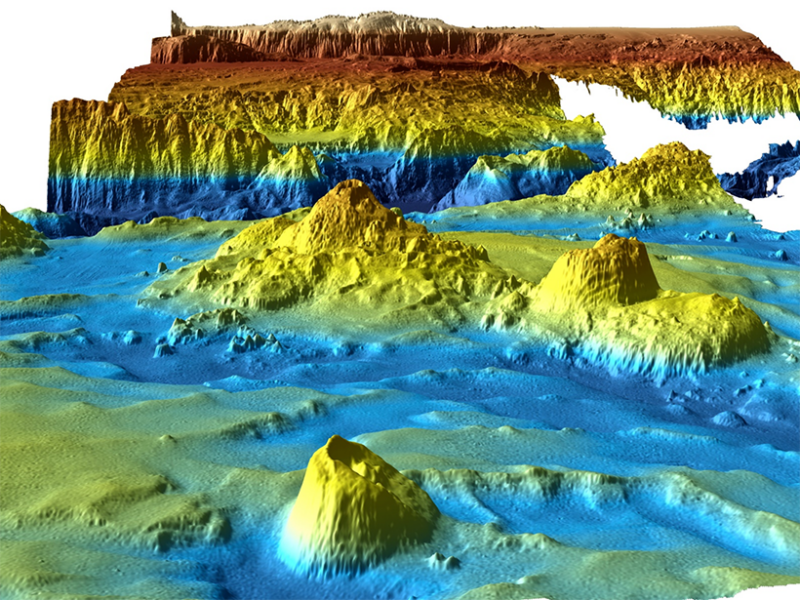
3-D image showing the diamantina Escarpment, looking northwest (upslope). The largest seamount in this area, about 1.5 kilometers high, appears in the foreground. In the middle and background, the escarpment and trough mark the northern margin of the rift. Vertical exaggeration is 3 times. Credit: Kim Picard and Jonah Sullivan.

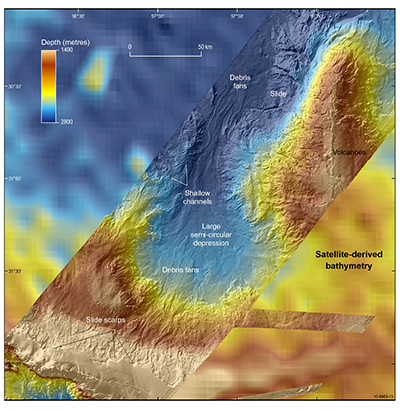
The differences in resolution between multibeam and satellite-derived bathymetry data for the northern flank of Broken Ridge are apparent here. Numerous mass wasting features are evident, including slides and debris flows (delineated by their head scarps) that crosscut and run out as debris fans into the large semicircular depression