Saturday 29 September 2018

1st to 7th October 2018

NEXT WEEKS EVENTS

1st to 7th October 2018

THE FOLLOWING IS AN EXTRACT FROM BRISTOL AND WEST COUNTRY GEOLOGY CALENDARS

MORE DETAILS CAN BE FOUND IN THE BRISTOL AND THE WEST COUNTRY CALENDARS AND ON THE WEB SITES OF THE RELEVANT SOCIETY OR ORGANISATION.


MONDAY 1st


Course - Geology of the Bristol and Gloucester Region.
When
Mon, 1 October, 19:30 – 21:30
Where
Wynstones School, Stroud Road, Whaddon, Gloucester (map)
Description
Geology of the Bristol and Gloucester Region. 
One of the most varied regions of Britain, spanning the major divisions of the Variscan Front/Bristol Channel-Bray Fault, and the Malvern fault/ Worcester Graben, incorporating rocks varying in age from late PreCambrian to Cretaceous, and three of the terranes making up the geological “jigsaw” of Britain. The course will cover roughly the area covered by the eponymous BGS publication in the British Regional Geology series (3rd edition 1992).  Starts Mon 17th September  for 10 weeks (not 22nd or29th Oct or 5th Nov), until 10th December   Held at Wynstones School, Stroud Road, Whaddon, Gloucester from 7.30-9.30pm on Mondays.  Cost £75 (including tea, coffee etc at breaktime!).

Contact Dave Green by email at davegeostudies@gmail.com, by phone at 01594 960858 and by post at Dave Green, Joys Green Farm, Lydbrook, Gloucestershire, GL17 9QU

Tuesday 2nd


Wednesday 3rd


Thursday 4th


Course - Understanding Geology and Scenery around Ross-on-Wye
When
Thu, 4 October, 10:00 – 10:30
Description
Understanding Geology and Scenery around Ross-on-Wye 
Starts September 21st (not 25th Oct or 8th Nov), finishes 6th December.
This 10 week course aims to introduce you to the ways in which the varied and beautiful landscape round our area has come into being. The effects of folds, faults and tectonic dip in exposing  different rock types, and the past and present processes of uplift, weathering, erosion and deposition that have acted upon them, will be examined by reference to local scenery. Use will be made of local maps and cross-sections across them, both geological and topographic; together with specimens of local rocks. Contact Paul Mason on  01989 760399. Cost £60  Enrol  before 15th September to ensure that the course runs.
-------------------------------------------

Bath Geol Soc - Lecture
When
Thu, 4 October, 19:30 – 21:00
Where
Bath Royal Literary and Scientific Institution, 16 Queen Square, Bath (map)
Description
Creating the critical zone: dissolving, fracturing, and eating rocks

Dr Heather L. Buss - Senior Lecturer in Biogeochemical Weathering - School of Earth Sciences, University of Bristol

The critical zone is the region of terrestrial Earth extending from the treetops to where rock begins to weather. It's critical because it provides many essentials that we need to survive on this planet - energy, nutrients, food, groundwater; it also mediates the release of toxins to the biosphere, controls water runoff and infiltration, affects the concentrations of greenhouse gases in the atmosphere, and generates dust and sediments. The creation of the critical zone from solid rock is a complex but fascinating set of interlinked processes of chemical reactions, physical transport, fracturing, and metabolism.

The feedbacks amongst these very different processes determine many of the characteristics of the critical zone, such as the shape of it, the depth of it, how fast it evolves, and the fertility of it. Because the critical zone is so critical, it's essential that we are able to preserve (or restore) its functions in the face of global and local environmental change. To do that, we need to understand exactly how these feedbacks work so that we can make accurate predictions of the consequences of environmental change as well as of our interventions. In this talk, I will discuss how these different processes are interlinked with a case study of spheroidal weathering in a tropical granitic rock, with extension to other lithologies and climate zones globally. 

friday 5th


saturday 6th


Sunday 7th


Jade mining and landslides

800 Deaths in Last 4 Years

One of my favourite blogs, The Landslide Blog, reports that there has been 800 deaths in the last 4 years in the jade mining area of Myanmar (formerly Burma). The blog records 33 fatal landslides in that period. It is the global hotspot for landslide fatalities.

Google Earth images show that environmental protection (and health and safety) were not prioritised. They seem to have been completely forgotten! Put Hpakant into the Google Maps search box and look at the Satellite images. The place is dreadful. Zoom out and you see that it is in an area of wooded hills which looks idyllic.


Sunday 23 September 2018

Minerals of the English Midlands

Minerals of the English Midlands

Roy Starkey the author of "Minerals of the English Midlands" has told me that this book is now available for purchase. I am sure some of you will be interested in getting a copy. He writes:-

I wanted to let you know that I have just published a major new book Minerals of the English Midlands (see attached pdf flyer) which may be of interest to your members. 

The book is a private project funded entirely by myself and is being distributed on a  not-for-profit basis – I seek only to recoup the cost of producing it. 

You can see more information on my website HERE and order a copy HERE.


Saturday 22 September 2018

24th to 30th September 2018

NEXT WEEKS EVENTS

24TH TO 30th SEPTEMBER 2018

THE FOLLOWING IS AN EXTRACT FROM BRISTOL AND WEST COUNTRY GEOLOGY CALENDARS

MORE DETAILS CAN BE FOUND IN THE BRISTOL AND THE WEST COUNTRY CALENDARS AND ON THE WEB SITES OF THE RELEVANT SOCIETY OR ORGANISATION.

MENDIP HILLS AONB HAVE A SERIES OF EVENTS WHICH HAVE ONLY RECENTLY COME TO MY NOTICE. THEY CAN BE DISCOVERED HERE. I HAVE INSERTED SOME OF THEM BELOW. VISIT THE WEBSITE FOR BOOKING DETAILS.

MONDAY 24TH

Course - Geology of the Bristol and Gloucester Region.
When
Mon, 24 September, 19:30 – 21:30
Where
Wynstones School, Stroud Road, Whaddon, Gloucester (map)
Description
Geology of the Bristol and Gloucester Region. 
One of the most varied regions of Britain, spanning the major divisions of the Variscan Front/Bristol Channel-Bray Fault, and the Malvern fault/ Worcester Graben, incorporating rocks varying in age from late PreCambrian to Cretaceous, and three of the terranes making up the geological “jigsaw” of Britain. The course will cover roughly the area covered by the eponymous BGS publication in the British Regional Geology series (3rd edition 1992).  Starts Mon 17th September  for 10 weeks (not 22nd or29th Oct or 5th Nov), until 10th December   Held at Wynstones School, Stroud Road, Whaddon, Gloucester from 7.30-9.30pm on Mondays.  Cost £75 (including tea, coffee etc at breaktime!).

Contact Dave Green by email at davegeostudies@gmail.com, by phone at 01594 960858 and by post at Dave Green, Joys Green Farm, Lydbrook, Gloucestershire, GL17 9QU

Tuesday 25th


wednesday 26th


thursday 27th

Course - Understanding Geology and Scenery around Ross-on-Wye
When
Thu, 27 September, 10:00 – 10:30
Description
Understanding Geology and Scenery around Ross-on-Wye 
Starts September 21st (not 25th Oct or 8th Nov), finishes 6th December.
This 10 week course aims to introduce you to the ways in which the varied and beautiful landscape round our area has come into being. The effects of folds, faults and tectonic dip in exposing  different rock types, and the past and present processes of uplift, weathering, erosion and deposition that have acted upon them, will be examined by reference to local scenery. Use will be made of local maps and cross-sections across them, both geological and topographic; together with specimens of local rocks. Contact Paul Mason on  01989 760399. Cost £60  Enrol  before 15th September to ensure that the course runs.

friday 28th


saturday 29th

BANWELL BONE CAVES TOUR– “GEOLOGICAL ASPECTS OF BANWELL CAVES AND FOLLIES”
September 29 @ 2:30 pm - 4:30 pm
£15.00
£15pp, (children under 16 free). Tea/cake or refreshments available.

A chance to see an early 19th Century pleasure garden with unique bone cave and follies/grottoes, not often open to the public.

Address: The Caves, Banwell Lane, BS29 6NA.

Limited places – booking essential. Payment in cash only at the gate to tour guide please. No card facility at the Caves.

Please arrive promptly for 2.15pm for start of tour at 2.30pm. Car parking inside gates of The Caves to the left.

Access and footwear: please wear grippy boots/shoes as their are approx 20 stone steps down into the caves, also grounds and gardens have some uneven ground and steps. Grounds and caves are unsuitable for limited mobility or young children or pushchairs.


sunday 30th


CHARTERHOUSE HISTORY AND BLACK DOWN INDUSTRIAL ARCHAEOLOGY WALK
September 30 @ 10:00 am - 2:00 pm
FREE

Join Dr Andrew Newton to discover the fascinating history of the Mendip Lead and other history on this walk of ~ 6miles. Drinks/waterproofs.

Parking at Blackmoor Reserve, Charterhouse, ST505 556.

Friday 21 September 2018

South Africa's newest Unesco World Heritage Site

Makhonjwa Mountains Declared Unesco World Heritage Site

When I was in South Africa this was known as Barberton Mountain Land - a name somewhat younger than the rocks. Henry and Fred Barber found gold there in 1884. The rocks have been there for about 3.57 billion years.

This web site tells the story of the rocks and the gold mining history of the area. (If you cannot get the site to open with your browser try another one. Chrome and Edge work in Windows, Opera does not.) This is very much a web site for tourists but there is a lot of geology to be found in the area and it is well worth visiting if you are in South Africa. And the pictures are nice.


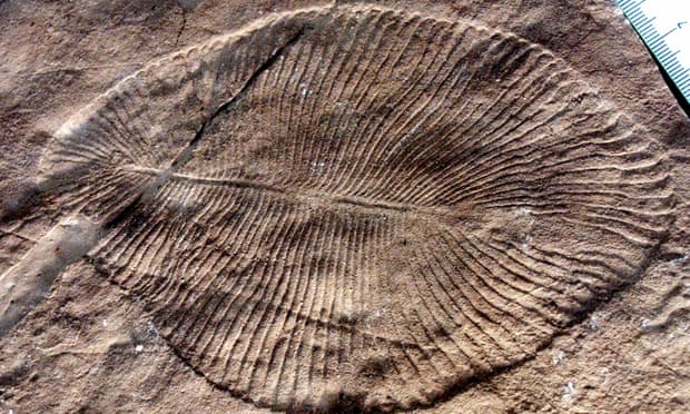
Cholesterol establishes Dickinsonia as one of the earliest animals

Dickinsonia - What is it? - Its a Very Ancient Animal.

Dickinsonia is a well known Ediacaran fossil. But it was usually described as being "enigmatic" - nobody knew what it was. Was it a lichen, an animal, a collection of single celled creatures or something else.

But we now know that, thanks to the discovery of cholesterol molecules in some well preserved Dickinsonia from northern Russia, they were animals. Possibly the first animals. They are, so far, the oldest animals.

Read all about it HERE, or HERE (if you have a subscription).


Saturday 15 September 2018

17th to 23rd September 2018

NEXT WEEKS EVENTS

17th to 23rd September 2018

THE FOLLOWING IS AN EXTRACT FROM BRISTOL AND WEST COUNTRY GEOLOGY CALENDARS

MORE DETAILS CAN BE FOUND IN THE BRISTOL AND THE WEST COUNTRY CALENDARS AND ON THE WEB SITES OF THE RELEVANT SOCIETY OR ORGANISATION.

MENDIP HILLS AONB HAVE A SERIES OF EVENTS WHICH HAVE ONLY RECENTLY COME TO MY NOTICE. THEY CAN BE DISCOVERED HERE. I HAVE INSERTED SOME OF THEM BELOW. VISIT THE WEBSITE FOR BOOKING DETAILS.

MONDAY 17TH

Course - Geology of the Bristol and Gloucester Region.
When
Mon, 17 September, 19:30 – 21:30
Where
Wynstones School, Stroud Road, Whaddon, Gloucester (map)
Description
Geology of the Bristol and Gloucester Region. 
One of the most varied regions of Britain, spanning the major divisions of the Variscan Front/Bristol Channel-Bray Fault, and the Malvern fault/ Worcester Graben, incorporating rocks varying in age from late PreCambrian to Cretaceous, and three of the terranes making up the geological “jigsaw” of Britain. The course will cover roughly the area covered by the eponymous BGS publication in the British Regional Geology series (3rd edition 1992).  Starts Mon 17th September  for 10 weeks (not 22nd or29th Oct or 5th Nov), until 10th December   Held at Wynstones School, Stroud Road, Whaddon, Gloucester from 7.30-9.30pm on Mondays.  Cost £75 (including tea, coffee etc at breaktime!).

Contact Dave Green by email at davegeostudies@gmail.com, by phone at 01594 960858 and by post at Dave Green, Joys Green Farm, Lydbrook, Gloucestershire, GL17 9QU

Tuesday 18th

Joint Meeting of HOGG and GCG (History of Geology Group and Geological Curators’ Group) Collectors, Collections and the geology of South West Britain
When
18 – 19 Sep 2018
Where
Bath Royal Literary & Scientific Institution, 16-18 Queen Square, Bath BA1 2HN, UK (map)
Description
Collectors, Collections and the geology of South West Britain


Tuesday 18th September 2018,

with a day of related field trips in Bath and immediate area on Wed 19th September

This collaborative meeting organised by two Special Interest Groups of the Geological Society focuses on the geology of South West Britain. We invite expressions of interest in presenting papers or posters on the broad topic of collectors and their collections related to the history of geology in the southwest, and on those who deciphered the geological story. Whilst William Smith and his role in mapping and stratigraphy has been very well presented in most recent years, there are many others whose stories remain less well known, such as William Lonsdale, who worked at both the Bath Literary and Scientific Institution and at the Geological Society. If there is sufficient interest, the proceedings may be published as a thematic issue of the GCG journal, The Geological Curator.

We invite any contributions on the meeting topic, especially on:

Collectors who worked in the southwest, contributing to the development of geological science. The role of more modern or even contemporary collectors should not be forgotten.
Collections from the southwest which are poorly known, or which have been returned to prominence with recent projects. These may be rock, fossil, mineral or archival collections.
Field geologists whose work and observations were important to the development of the science, without necessarily having made significant collections.
A series of social events are also planned but we do not expect registration for the first day to cost more than £20 maximum, with discounted rate for members of HOGG, GCG, BRLSI and Bath Geological Society. The second day will be costed on individual options, but some choices (e.g. cemetery and building stone walks) will be free.

Closing date for expressions of interest is April 30 and submission of abstracts (max 350 words) must be completed before May 18. Please submit to: swmeeting@geocurator.org 

If you require further information on this call or on the meeting, please contact one of the organisers:

Matthew Parkes (GCG) mparkes@museum.ie, +353-87-1221967

Nina Morgan (HOGG) nina.morgan@cooptel.net +44-1608 676530 (or 01608 676530).
-----------------------------------------
MENDIPS NATURAL RESOURCES
September 18 @ 7:00 pm - 8:30 pm
£3.00
BOOK HERE

A talk by geologist David Rowley from Wells Cathedral School to discover more about Mendip’s unique geo resources.

Parking available at WCS.

Tickets £3 donation.
-----------------------------------------------


SMFS Evening Meeting
When
Tue, 18 September, 19:30 – 22:00
Where
The Friends' Meeting House, 1A, Ordnance Rd, Southampton. SO15 2AZ (map)
Description
The Dinosaurs of Crystal Palace, and a world of spin-off illustrations. Presentation by Phil James.
Members’ Display Table: Dinosaur fossils & memorabilia.

Wednesday 19th

JOINT MEETING OF HOGG AND GCG (HISTORY OF GEOLOGY GROUP AND GEOLOGICAL CURATORS’ GROUP) COLLECTORS, COLLECTIONS AND THE GEOLOGY OF SOUTH WEST BRITAIN
WHEN
18 – 19 SEP 2018  See Tuesday above.

Thursday 20th

OUGS Oxford - Field Meeting, Wonderful Geology in Western Ireland
When
20 – 25 Sep 2018
Where
Dingle Peninsula and County Clare (map)
Description
Wonderful Geology in Western Ireland 

Leader: Dr Brian Williams 

Location: Dingle Peninsula and County Clare 

Date: September 20th–25th, 2018 

Type: Longer Trip 

Summary: An extended weekend trip led by Dr Brian Williams as an introduction to the remarkable geology of County Clare and West Kerry. Please contact the organiser to express interest. 

SHANNON & DINGLE BASINS; varied sedimentary infill architecture and tectonic settings in Mid to Late Palaeozoic basins of W. Ireland.

(Prof. Brian Williams, Geological Sciences, Universities of Aberdeen & Dublin)

The Namurian sediments of the Shannon (Clare) Basin preserve a range of depositional environments from turbidite fans, through slope deposits to deltaic systems. This Upper Palaeozoic clastic suite was accommodated in an intraplate location which had developed over the Iapetus Suture; the Basin's downwarp history clearly reflecting re-activation of this Caledonian feature. Thickness and facies variations in the Visean/Namurian sediments indicate that the Basin was centered on an ENE – WSW lineament [the Silvermines – Navan "line”] which is believed to be an extension of the Solway Firth Lineament. During the Namurian the Basin was filled by over 1.5 km of sediment. The clastic suite is preserved in the broadly synclinal W. Clare Basin and comprises a fine to medium grained sediment supply derived mainly from the W and SW via fluvio-deltaic. Sedimentation rates were generally high except during periods of rising relative sea level when slowly-deposited marine bands were developed.

In total contrast, the Siluro-Devonian sediments of the Dingle Basin preserves the most complete marine Silurian to ORS magnafacies (+ 4 km thickness) in W. Ireland which is structurally constrained between two fundamental (Caledonian) ENE-trending structural lineaments lying south of the Iapetus Suture zone. These bounding faults, of sinistral strike-slip style, exerted major control on the sedimentary architecture of this Basin fill. The broadly upward-coarsening sediment infill initially reflects the final phases of Iapetan subduction through the accumulation of lavas and volcaniclastics interbedded with shallow marine Silurian sediments; the overlying, continental ORS sediments exhibit a UC motif from lacustrine through ephemeral-fluvial to perennial-fluvial and alluvial fan sediments to complete the Basin fill prior to the late Lower Devonian [Emsian] Acadian Orogeny.

Professor Brian Williams

Brian is the Emeritus Professor of Petroleum Geology at the University of Aberdeen, Scotland and is also Adjunct Professor at University College Dublin in Ireland. He has held teaching positions in the Universities of Bristol, Reading, Cork and Manchester, and also in the Netherlands, Canada and the USA. He is a Fellow of the Geological Society of London and a Member of the Energy Institute, and has published over 100 papers and written/edited several books including "New Perspectives on the Old Red Sandstone”.

Brian gained his B.Sc. and Ph.D. in Geology from the University of Wales (Swansea), and in 2004 was further awarded a D.Sc. degree by that University in recognition of his global contribution to geological research on Mid to Late Palaeozoic Continental Sedimentary Systems; much of which was on the ORS of SW Wales, SW Ireland and E Canada. In addition to the UK and Ireland, his studies have taken him to Australia, SE Asia, Middle East, Europe and North America which has given him the opportunity to share his enthusiasm for sedimentary rocks and earth processes with varied audiences from undergraduate and post graduate students [he has supervised 40 Ph.D. research projects] to industry personnel and adult education/alumni groups.

In addition to being passionate about Geology, Brian is an ardent Rugby enthusiast [he's Welsh, of course!!], and a devoted follower and presenter of American Jazz (bi-monthly programmes on "Magnetic Radio”, out of Glasgow).

Itinerary for the trip is:

Thurs. 20 Sept. - am Fly LHR - Shannon (pick up rental cars); pm Loop Head geology [Kilkee - Bay View B&B]

Fri. 21 Sept. - am Shannon geology boat excursion; pm Tullig & Kilkee coastal geology [Kilkee - Bay View B&B]

Sat. 22 Sept. - am drive, via Shannon ferry, to N. Kerry - Ballybunion geology; pm to North Dingle - mountain geology & scenery [Dingle Town – Dingle Harbour Lodge]

Sun. 23 Sept. - am Geology of the Dunquin Group (W. Dingle); pm Dingle/Smerwick Basins - terrain boundary [Dingle Town – Dingle Harbour Lodge]

Mon. 24 Sept. - am Geology of the Dingle Group (W&S.Dingle); pm traverse Smerwick Group (N.Dingle) [Dingle Town – Dingle Harbour Lodge]

Tues. 25 Sept. - am Geology of the Caherbla Group (E. Dingle); pm drive to Cork for ORK - LHR flight [late afternoon]

If you are making your way by other routes please ensure your arrival by the start time indicated.

Note the dates have changed since first announced bringing the whole trip forward by one week.

Please complete the Booking Form as soon as possible.     

Please note the dates have changed since first announced bringing the whole trip forward by one week.      
----------------------------------------------

Course - Understanding Geology and Scenery around Ross-on-Wye
When
Thursday, 20 Sep 2018
Description
Understanding Geology and Scenery around Ross-on-Wye 
Starts September 21st (not 25th Oct or 8th Nov), finishes 6th December.
This 10 week course aims to introduce you to the ways in which the varied and beautiful landscape round our area has come into being. The effects of folds, faults and tectonic dip in exposing  different rock types, and the past and present processes of uplift, weathering, erosion and deposition that have acted upon them, will be examined by reference to local scenery. Use will be made of local maps and cross-sections across them, both geological and topographic; together with specimens of local rocks. Contact Paul Mason on  01989 760399. Cost £60  Enrol  before 15th September to ensure that the course runs.
-------------------------------

Thornbury Geology Group, 7.30pm, The Chantry, Thornbury
When
Thu, 20 September, 19:00 – 21:30
Description
Thornbury Geology Group, 7.30pm at The Chantry, Thornbury, and every 3rd Thursday in the month


friday 21st

OUGS OXFORD - FIELD MEETING, WONDERFUL GEOLOGY IN WESTERN IRELAND
WHEN
20 – 25 SEP 2018 - See above

saturday 22nd

OUGS OXFORD - FIELD MEETING, WONDERFUL GEOLOGY IN WESTERN IRELAND
WHEN
20 – 25 SEP 2018 SEE ABOVE
---------------------------------------------

STONE CARVING WORKSHOP WITH TANYA JOSHAM
September 22 @ 10:00 am - 4:00 pm
£20.00
BOOK HERE

Stone Carving Workshop with Tanya Josham at Somerset Earth Science Centre, Stoke St Michael, BA3 5JU.

Learn the craft of stone carving using Bath stone, carve a simple piece for your garden or home, £20 for materials/tools/hot drinks, but bring lunch.

Limited places, 10 max.


Sunday 23rd


OUGS OXFORD - FIELD MEETING, WONDERFUL GEOLOGY IN WESTERN IRELAND
WHEN
20 – 25 SEP 2018 SEE ABOVE

---------------------------------------------
Undercliffs Guided Walk
When
Sun, 23 September, 10:00 – 15:00
Where
Pinhay House, Pinhay House, Lyme Regis, Dorset, DT7 3RQ (map)
Description
Enjoy a 5-mile walk through the Axmouth to Lyme Regis Undercliffs National Nature Reserve. 
Though the focus of this walk will be a ‘fungal foray’ there is also the opportunity to experience the geology and geomorphology of this extensive coastal landslip environment. 
Join local fungi expert Dr David Allen to hunt for mushrooms in the wilds of the Undercliffs National Nature Reserve. We will explore the area below Pinhay including the secluded and remote Humble Glades, a series of open sheltered areas of grassland, and the surrounding woodland. 
Meet at Pinhay House at 10:00am. Estimated 4 hours for the walk with an hour’s lunch break, finishing by 3:00pm. 
Further information and Booking 
----------------------------------------------------

Bumps in the Bay. Newly discovered seafloor structures in Weymouth Bay
When
Sun, 23 September, 14:30 – 14:30
Where
The Etches Collection, Museum of Jurassic Marine Life, Kimmeridge, Dorset, BH20 5PE, United Kingdom (map)
Description
The remarkable seafloor images of Weymouth Bay obtained by Dorset Wildlife Trust’s DORIS project provide new insights into the geology of the Jurassic Coast. Large circular structures revealed in the Purbeck Limestone have not previously been seen in any of the coastal cliffs or quarries from Durlston Bay to Portland, despite over a hundred years of geological research. Many geological processes can generate circular arrangements of strata from meteorite impacts to collapsed caves, volcanoes, reefs or to salt injection structures. The talk will describe the structures as revealed in echo sounding images, explore the different interpretations and the implications for our understanding of this classic geological area. 
Speaker: Dan Bosence, Emeritus Professor Geology, Royal Holloway University of London. 
With welcome and introduction about the DORIS project by Peter Tinsley, Dorset Wildlife Trust. 
Entry by donation on the door. 
To reserve your seat contact Julie Hatcher
01929 481044
kimmeridge@dorsetwildlifetrust.org.uk 
Bumps in the Bay poster 

Rock nationality fuss

Is/Was Cornwall French?

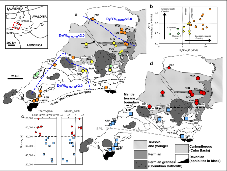
New research from Plymouth University shows that lamprophyres from Cornwall and South Devon have more in common with those in Armorica (that is France) than they do with Avalonia (that is England). From this they deduce a terrane boundary between the two. The article is well worth looking at.

Very interesting, but not interesting enough for the Guardian who dress it up in terms such as "researchers have discovered that there is a corner of Britain that will forever belong to mainland Europe."

They cover the gist of the article well enough but this rock nationality stuff annoys me. So far, pebbles do not need to carry a passport.

Geospatial analysis of post-Variscan lamprophyre geochemistry in southwest Britain. Inset map shows location of study area, with the generally assumed location of the Rheic suture marked by the Lizard-Start ophiolites complex. a Map of the study area with sample localities. Samples marked with circles are minette-type lamprophyres, squares are kersantite lamprophyres, and diamonds are mica-free K-rich lavas. Samples are also colour-coded based on K2O/Na2O ratios. Orange samples are ultrapotassic (K2O/Na2O >2.2) and represent the lowest degree of mantle melting; yellow symbols are potassic (1 < K2O/Na2O <2.2) and green symbols represent samples with K2O/Na2O <1. Two dashed contour lines delineate areas in north and south where deepest-derived magmas were emplaced, based on N-MORB normalized Dy/Yb ratios >2. b Chart showing negative correlation between depth and degree of melting. c Initial Sr and Nd isotope ratios calculated at 290 Ma plotted against northing (Ordnance Survey UK grid coordinates), showing a clear jump in values across thick dashed line. d Map showing the samples assigned to group 1 (red circles) and group 2 (blue squares) based on their initial Sr and Nd isotope ratios. Surface trace of the boundary between the two isotopically distinct lithospheric mantle domains is interpreted as a cryptic terrane boundary in the mantle lithosphere buried beneath Paleozoic metasedimentary rocks. SPL refers to the Start-Perranporth Line (see text). Data for locations TOW (Towan Head), HOB (Holywell Beach), TRE (Trelissick), HEL (Helfort) and FRE (Fremington Quay) are from ref 35. (only Nd data); all other data from this study. Locations are listed in Supplementary Table 1. Map adapted from regional view geological map from British Geological Survey59. © Crown Copyright and Database Right 2018. Ordnance Survey (Digimap Licence)

Tuesday 11 September 2018

Submarine landslide, Boso Peninsula

Submarine Landslide, Boso Peninsula

I came across this fantastic photograph on the internet. It comes from the Boso Peninsula which is across Tokyo bay from Yokohama. Credit for this photo goes to Dr. Yuzuru Yamamoto of the Japan Agency for Marine-Earth Science and Technology. It is not a hand specimen - note the people on the left!


Saturday 8 September 2018

10th to 16th September 2018

NEXT WEEKS EVENTS

10th to 16th September 2018 

THE FOLLOWING IS AN EXTRACT FROM BRISTOL AND WEST COUNTRY GEOLOGY CALENDARS

MORE DETAILS CAN BE FOUND IN THE BRISTOL AND THE WEST COUNTRY CALENDARS AND ON THE WEB SITES OF THE RELEVANT SOCIETY OR ORGANISATION.

MENDIP HILLS AONB HAVE A SERIES OF EVENTS WHICH HAVE ONLY RECENTLY COME TO MY NOTICE. THEY CAN BE DISCOVERED HERE. I HAVE INSERTED SOME OF THEM BELOW. VISIT THE WEBSITE FOR BOOKING DETAILS.

MONDAY 10th

“SKETCHING THE QUARRY FACES AT FAIRY CAVES” ADULTS WORKSHOP AT FAIRY CAVE QUARRY, LIMEKILN LANE, STOKE ST MICHAEL
September 10 @ 2:00 pm - 4:30 pm
£10.00
BOOK HERE

Guided by art tutor, be inspired to draw the dramatic rock faces of the disused quarry, responding in charcoal & paper or bring art materials of your choice. Quarry rarely open to the public.

Parking: On lane side & in private carpark on Limekiln Lane, Stoke St Michael, ST657347.

Limited places. £10pp.


Info: 01749 840156.

TUESDAY 11TH


Wednesday 12th


Thursday 13th

Triassic Coast Cruise
When
Thu, 13 September, 18:00 – 21:00
Where
Stuart Line Cruises, Exmouth Marina Ltd, Pier Head,, Exmouth, Devon, EX8 1DS (map)
Description
A cruise through the oldest section of the Dorset and East Devon World Heritage Coast, accompanied by expert commentary from local Jurassic Coast Trust Ambassadors. 
Setting off at 6:00pm, we will cruise from Exmouth to Sidmouth, taking in the breath-taking Triassic cliffs of  Orcombe Point, Ladram Bay, Sidmouth and more. We will return to Exmouth for 9:00pm. 
We will be accompanied by music from the Exmouth Shantymen on the voyage back to Exmouth. 
We hope to have some nice early evening light for the voyage out, and will have on-board lighting on the trip back to Exmouth. 
Prices: £10 for adults, £8 for children. 
Food and drink: Drinks available to purchase on board. Please feel free to bring your own food on board with you. 

More information and Booking HERE

Friday 14th


Cheltenham Mineral and Geological Society - Lecture
When
Fri, 14 September, 19:00 – 21:00
Where
Shurdington at The Century Hall (map)
Description
    'The Geology and Mineralogy of Welsh Gold '


    Our guest speaker is  Tom Cotterell, Senior Curator of Palaeontology , National Museum,Wales.

Saturday 15th

South Wales GA - Field Meeting
When
Saturday, 15 Sep 2018
Description

Three Cliffs Bay and Ilston, Gower: (Paul Wright)
-----------------------------------------------------------------
South Gloucestershire Mines Research Group - Colliery Open Day
When
Sat, 15 September, 14:00 – 17:00
Where
Oldwood Pits, Tanhouse Lane, Rangeworthy, near Yate, BS37 7PZ (map)
Description
Guided tours of colliery site remains. 
Display of local mining artefacts

Refreshments

Sunday 16th


South Gloucestershire Mines Research Group - Colliery Open Day
When
Sun, 16 September, 11:00 – 15:30
Where
Oldwood Pits, Tanhouse Lane, Rangeworthy, near Yate, BS37 7PZ (map)
Description
Guided tours of colliery site remains. 
Display of local mining artefacts

Refreshments