Monday, 30 December 2024

Fossil Tree Found at Saltern Cove, near Paignton

 Fossil Tree Found at Saltern Cove, near Paignton

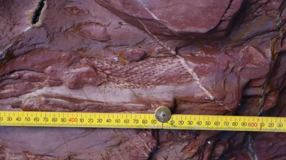
A correspondent alerted me to THIS WEB PAGE on the BBC website. It concerns the finding of a lycopsid (tree) fossil at Saltern Cove. It is important because the area was thought to be marine in the Devonian and the tree indicates that there was a desert island. I wonder if the tree grew here or whether it floated in.


You can find out a great deal more about the find at THIS ARTICLE published by the English Riviera Global Geopark.

Monday, 23 December 2024

Making "White" Hydrogen - Pity About the Ophiolite

 Making "White" Hydrogen - Pity About the Ophiolite

I came across THIS ARTICLE which discusses the various means of making Hydrogen, most of which are very environmentally unfriendly. There is a colour coding of Hydrogen which describes how it is made.

And the "greenest" hydrogen is White Hydrogen! This is already being produced by natural geochemical processes. This involves the weathering of basic igneous rocks.

This could be industrialized by pumping water and carbon dioxide into ophiolites. This produces serpentine, magnesium carbonate and hydrogen. So get rid of carbon dioxide and produce hydrogen! 

This sounds very good. Presumably there would be difficulties, but the techniques used are those of the oil industry which might encourage their use.

As far as I am concerned the downside is the change of lovely ophiolites into less lovely serpentinites.


Saturday, 14 December 2024

Nautilus Video

 Nautilus Video

A correspondent alerted me to this video and it makes nice pleasant viewing. It is even more pleasant if you mute the sound.


All you need to know about Nautilus can be found HERE.

Saturday, 30 November 2024

Down to Earth Extra December 2024

 Down to Earth Extra December 2024

The December 2024 edition of Down to Earth Extra has been published. You can download it HERE or you can read it below.


Saturday, 16 November 2024

Crystals Hold Secret of When Volcanoes Erupt

Crystals Hold Secret of When Volcanoes Erupt

I came across THIS ARTICLE in the New Scientist and found it very interesting for several reasons. Its about igneous petrology, Hawaii and volcanoes - what more do you need! It is based on THIS PAPER in Nature.

The researchers used several techniques of studying crystals - mainly olivine - from the 2022 eruption of Maunu Loa to determine the history of the crystals before the eruption. And they found that they had started moving into a higher magma chamber 70 days prior to the eruption. The eruption occurred when this chamber was full.

And seventy days prior to eruption a change in earthquake frequency and ground bulging (inflation) was noticed.

So if a similar change in inflation and earthquake frequency was noticed a warning of imminent eruption could be given.

Studies to see if similar things happened to Mauna Loa and other volcanoes prior to other eruptions are being carried out.

But the Hawaii volcanoes are among the most studied anywhere. Is there sufficient knowledge of other volcanoes to make predictions?

Looking at the Nature paper reminds me that igneous petrology has moved on considerably since I was a student!


A Map of Mauna Loa summit and upper Northeast Rift Zone (Island of Hawai‘i on inset map) with 2022 lava flow field78 (pink), lava flows since CE 184379,80 (dark gray), 1000 ft (~305 m) contours (brown lines), samples (black dots; green for large-volume tephra samples used for mineral chemistry), and monitoring network stations (various symbols; see Fig. S1 for wider view that includes all GPS stations in this study). Basemap generated from a 2005 NOAA digital terrain model81 and a 1983 USGS digital elevation model82. Caldera bounding faults are denoted as black lines with teeth pointing to the downthrown side and 2022 eruptive fissures are denoted with red lines. The 2022 flows crossed the NOAA Observatory access road (dashed black line) and came within ~3 km of Highway 200 (Daniel K. Inouye Highway, “Saddle Road”). B 3-D X-ray computed tomography scan (μCT scan) of an olivine from sample ML22-88 shows the rounded morphology typical of phenocrysts from this eruption and inclusions of melt (yellow), Cr-spinels (red), and fluids (blue). C Phosphorus and D magnesium X-ray element maps of an olivine crystal. Sharp truncations in phosphorus zoning record at least two dissolution events. Patchy zones of truncated high-phosphorus in the phenocryst interior represent older resorption histories, whereas truncation of secondary phosphorus branches by the crystal-melt boundary record the youngest resorption event that is also evident in the rounded morphology of the phenocryst. Diffusion gradients in magnesium show obvious differences along the a- vs. c-axes (shown in lower-hemisphere stereonet inset in C), a result of diffusion anisotropy. Part of the crystal rim in the a-axis direction also shows subtle skeletal rim texture, evidence of late-stage crystal growth.

Saturday, 2 November 2024

Down to Earth Extra November 2024

 Down to Earth Extra November 2024

The November 2024 edition of Down to Earth Extra has been published. You can download it HERE or you can read it below.


Wednesday, 23 October 2024

Giant Meteorite Strike - the Pluses and Minuses

 Giant Meteorite Strike - the Pluses and Minuses

A correspondent sent me THIS LINK, concerning a giant meteor strike which happened ~3.26 Ga in what is now the Barberton Greenstone Belt of South Africa. I now know that 8 meteorite impacts (identified by small spherules and iridium anomalies) occurred in the greenstone belt. They have been given S numbers and here we are dealing with S2.

The size of the meteor was huge - 40 to 60km across. The Earth it struck was very different from that of today - mostly sea with a few continents. Life was single celled organisms. The meteorite created a 500km crater, a cloud of hot rock dust that circled the globe, ripped up the sea bed and created a huge tsunami. 

But it is not all bad news. Phosphorus and iron were churned up and dispersed. This could be considered as the spreading of fertiliser! It is always good to look on the bright side of life!

The basis of the BBC article is THIS ACADEMIC PAPER. This goes into the minutiae of the investigation and gives much greater detail. 


Rock and thin section images of the Bruce’s Hill and Umbaumba sections. (A–C) Outcrop photos of the Umbaumba section. (A) Overview of the Umbaumba section showing, from base to top, BWBC, S2, fallback layer, and BWBC. (B) S2 spherule bed. (C) Lower part of the fallback layer showing fine laminations. This black chert is composed of silicified carbonaceous matter, siliciclastic debris, and impact-generated dust settling out of the atmosphere. (D and E) Outcrop photos of the Bruce’s Hill section. (D) BWBC below S2. (E) Alternating siliciclastic and siderite-rich chert beds. (F–G) Representative thin section images of carbonaceous matter. (F) Laminated carbonaceous chert below S2 in the Umbaumba section (SI Appendix, Fig. S4). Red arrows indicate fractures filled by chert. (G) Clots of carbonaceous matter and other siliciclastic debris from the fallback later in the Umbaumba section.

Tuesday, 15 October 2024

Etheldred Benett Memorialised

 Etheldred Benett Memorialised

Etheldred Benett unveiling 

All Saints Church, Norton Bavant 24th September 2024

A chance reference to Etheldred Benett crossed my desk some years ago and I was immediately hooked. To discover that this remarkable woman was born and lived in Wiltshire, just a few miles from my own home village, was a revelation. It turned out that she also explored the surroundings of my own village, Dinton, looking for fossils. She found at least one, an unidentified ammonite. I subsequently found that she was but one, albeit the most fascinating, of geology’s early pioneers, and the only woman, among those who were very active in Wiltshire, Wiltshire can rightly claim to have made a unique contribution to the development of our science in the 18th and 19th centuries. (See Sarum Chronicle issue 2022 ISBN 978-1-9161359-5-6)

A few years before its unveiling in 2022 in Lyme Regis, a young local girl had asked her mother why there was no statue to such a famous fossil collector as Mary Anning, a contemporary of Etheldred Benett. By May of that year, over £100k had ben raised and the statue was unveiled by such luminaries as Prof Alice Roberts and Prof Hugh Torrens. I spoke to Prof Torrens on the day and outlined plans for a more modest memorial for our local hero, EB. As the person who rediscovered her collection at the Philadelphia Academy of Natural Science in the US he was delighted. Alas, now, due to health reasons,  he cannot receive emails so probably does not know that EB’s memorial has been installed.

I visited All Saints Church in the village of Norton Bavant near Warminster to see the Benett family mausoleum and the family chapel. The Benetts were huge landowners which included the manor house in Norton Bavant where EB lived for 43 years. To my surprise there was not a single reference to EB in the church for her geological work. That just had to change!

My approaches and suggestions to the Parochial Church Council (PCC) were positively received so then the task of raising funds to pay for a memorial board kept me busy. The PCC had the daunting task of applying for a faculty, the permission to make changes to the church given by the local diocesan authorities, nearly always a tortuous event.


All my enquiries for a grant received a positive response. I am truly grateful for the financial support that made the memorial possible. The sponsors were:

  • Wiltshire Council which gave the largest sum as allocated by the Area Board for the Warminster area.

  • HOGG gave a contribution and gave advice on the wording used on the memorial board.

  • The Curry Fund of the GA gave funds. Dennis Curry, who was a gifted geologist, was the oldest son of the founder of Curry’s the electrical retailer. He took over the firm on the death of his father. His generous gift of shares to the GA provided the capital for the establishment of the Curry Fund which makes grants to support geological projects throughout the country. This is not the first time that the Wiltshire Geology Group has used grants from the Curry Fund. Some years ago when Curry’s, the business, was involved in restructuring an individual involved bought Pyt House, the birthplace of EB. That property is now on the market again at £18 million – small world!

  • Lovell Stone now own Chicksgrove Quarry near Tisbury, the location for EB’s first ever measured and labelled geological section in 1815, described as ‘an indefatigable feat’. Simon Hart, the CEO also made a donation.

  • Professor Renee Clarey of Mississippi State University also secured a donation from the Geological Association of America. 

Following an item in a geological email I received indicating that Prof Clarey was preparing a data base of locations important in the historical development of geology, I wrote enquiring if Chicksgrove Quarry was on her list. It was not but Prof Clarey and I exchanged a number of emails and on a conference visit to the UK we met and I took her to Chicksgrove Quarry. We were also generously invited to lunch with Sir Henry Rumbold and his wife who live at Hatch House, once part of John Benett’s vast estate. Sir Henry is a descendant of one of EB’s brothers (EB never married) and has displayed at his home a portrait of EB as a young woman as shown on the memorial board.

The unveiling took place on 24th September in All Saints churchyard. Twenty people were in attendance, including Sir Henry Rumbold, a representative from Wiltshire Council, members of the PCC, WGG members, the current owner of EB’s old home next to the church and a journalist from the Warminster Journal. Kindly provided by the PCC, we enjoyed tea and refreshments in the church, following the formalities.


After nearly 200 years, EB now has a modest memorial in her home churchyard which captures a little of her huge contribution to the early development of the science of geology.

Etheldred Benett – RIP.

Steve Hannath

Chair of Wiltshire Geology Group


Saturday, 5 October 2024

Hurricane Helene - an Interesting Video

 Hurricane Helene - an Interesting Video

A correspondent brought THIS VIDEO to my attention. I concerns the devastation brought about by Hurricane Helene. He comments:- 

This is a fascinating piece, because in the second section of the destroyed road, it looks to me that the road has been built on an ancient river course that has been reactivated for the first time in centuries. 

Two Indoor Courses from Nick Chidlaw

 Two Indoor Courses from Nick Chidlaw

Nick Chidlaw has asked me to pulicise the following two courses to be held in November. Happy to oblige.

===================================

I am offering two 1-day indoor courses to be run in November, if there is sufficient interest and enrolments to make them viable. 

These courses are independent of one-another  - you can enrol on either or both, according to your interest and availability. 

The courses are being offered on the same weekend: some people who live a substantial distance away may be interested in both courses and this would make attending them more workable. Venue: The Chantry, Thornbury, South Gloucestershire www.thechantry.org.uk. Do let me know if you need advice on accommodation options.

I hope you find these proposals of interest, and to hear from you soon.

Nick Chidlaw 


Title:  The Chalk Group exposed at Westbury Chalk Quarry, west Wiltshire 

Saturday 23rd November 10.00 am - 5.00 pm


Image: Westbury Chalk Quarry in the 1990's. Extraction and processing ended before 2010; the site has since been gradually weathering and becoming overgrown.

In Late Cretaceous times (100 - 66 million years ago), the area of the earth's crust that became the British Isles lay about 45 degrees north of the equator and had a warm, subtropical arid climate. The global climate was much warmer than today, and sea surface temperatures around Britain are thought to have been around 28 degrees C.  An absence of polar ice caps ensured higher sea levels; these were compounded by very active tectonic plate growth and associated buoyancy of ocean ridges, displacing ocean water onto the continents. Across the British crust, few land areas remained, and the sea is thought to have been at times as much as 500m deep. Its sea bed was mainly a quiet environment, where sediment accumulated, often without disturbance. Material from the land consisted of occasional inputs of clays, and the waters were consequently very clear.  The warm, clear waters contained abundant dissolved lime, and near the surface innumerable microscopic calcareous algae were present, taking from this lime to build their  shells. Their consumption by planktonic crustaceans, and incorporation into faecal pellets, is thought to have enabled them to sink to the sea floor and accumulate, to form the  Chalk Group. In the Westbury area, crustal subsidence was lower than in some other parts of Britain, and in consequence the stratigraphic succession is thinner: this has resulted in a wide variety of Chalk Group stratigraphic units being exposed at Westbury Chalk Quarry. On this one-day course, powerpoint-based lectures will provide an introduction, geological history, and description of geologists' methods for studying the Chalk Group; this will be followed by a practical session in which specimens of mineral and rock types collected from Westbury Chalk Quarry will be examined under the tutor's guidance.

No prior geological knowledge or of the study location would be assumed. 

Tuition fee: £33.00

Contact tutor Dr Nick Chidlaw nickchidlaw@gmail.com to enrol and for any queries. 

Deadline for course viability: Friday 1st November. If the course has become viable (minimum 10 enrolments) by this date, enrolments will be able to continue until 1 week (Saturday 16th November) before the course runs. 

--------------------------------------

Title: Indoor practical course using hand specimens: metalliferous mineralisation within a sedimentary rock host

Sunday 24th November 10.00 am - 5.00 pm.


Image: an example of a metalliferous mineralisation setting in sedimentary rocks (not from the case to be studied on this course).

On this course hand specimens of minerals and sedimentary rocks are examined by attendees, using guidance notes to systematically determine, as far as possible, the identity of each specimen. This is good practise in learning how to analyse minerals and rocks, giving those on the course experience which they can use in the future to independently determine what specimens might me that they collect themselves, or are asked by others to identify. The course develops knowledge in attendees of the limits of hand specimen identification, and where laboratory methods would be needed to take the identification further; a number of possibilities may be concluded for some of the hand specimens.This process occupies most of the time on the course. The identifications of the minerals and rock specimens will then be given by the tutor, so that attendees will know which they have correctly determined, or where improvements can be made. 

Attendees are then each given an A3-sized annotated diagram on which they allocate the identified minerals and rocks. This diagram is of an actual example of metalliferous ore deposits within a series of sedimentary rocks, which have been, and continue to be, mined today. Attendees are to fill in blanks in the annotations, through knowledge they have gained from the specimen identification process, and from advised reading material brought to the course (including via online sources using attendees' smartphones / laptops).

The final part of the course will be an informal powerpoint-based lecture identifiying and describing the actual example of mineralisation being studied.  

No prior knowledge of geology would be assumed. 

Tuition fee: £33.00

Contact tutor Dr Nick Chidlaw nickchidlaw@gmail.com to enrol and for any queries. 

Deadline for course viability: Friday 1st November. If the course has become viable (minimum 10 enrolments) by this date, enrolments will be able to continue until 1 week (Saturday 16th November) before the course runs. 

===================================================

Saturday, 28 September 2024

Earth may once have had a ring like Saturn

 Earth may once have had a ring like Saturn

I came across THIS ARTICLE in New Scientist and was impressed by the way so many concepts are combined. 

There is a cluster of meteor impacts (21 of them) dated in the Ordovician after 466 million years ago. If you undo the subsequent movements of the continents you find most of the impacts were near the equator of the period. 

There is a period starting in 466Ma and lasting for 40 million years where there is a higher level of chondrite material in the rocks than one would expect.

THE PAPER on which the New Scientist article is based, gives an explanation for all this. The Earth had a near miss from a large chondrite meteorite. It did not strike the Earth but broke up due to the gravitational forces occassioned by its closeness to the Earth.

The meteorite debris formed a ring around the equator and bits of it fell to Earth in the subsequent few million years to give the impacts close to the equator. Smaller bits falling gave the increase in chondrite flux.

It may be connected that the Earths temperature dropped at this time to the lowest temperature of the last 540 m.y. Perhaps the postulated ring caused this.


Friday, 20 September 2024

Down to Earth Extra October 2024

 Down to Earth Extra October 2024

The October 2024 edition of Down to Earth Extra has been published. You can download it HERE or you can read it below.


Friday, 23 August 2024

Mantle Waves Form Mountains

 Mantle Waves Form Mountains

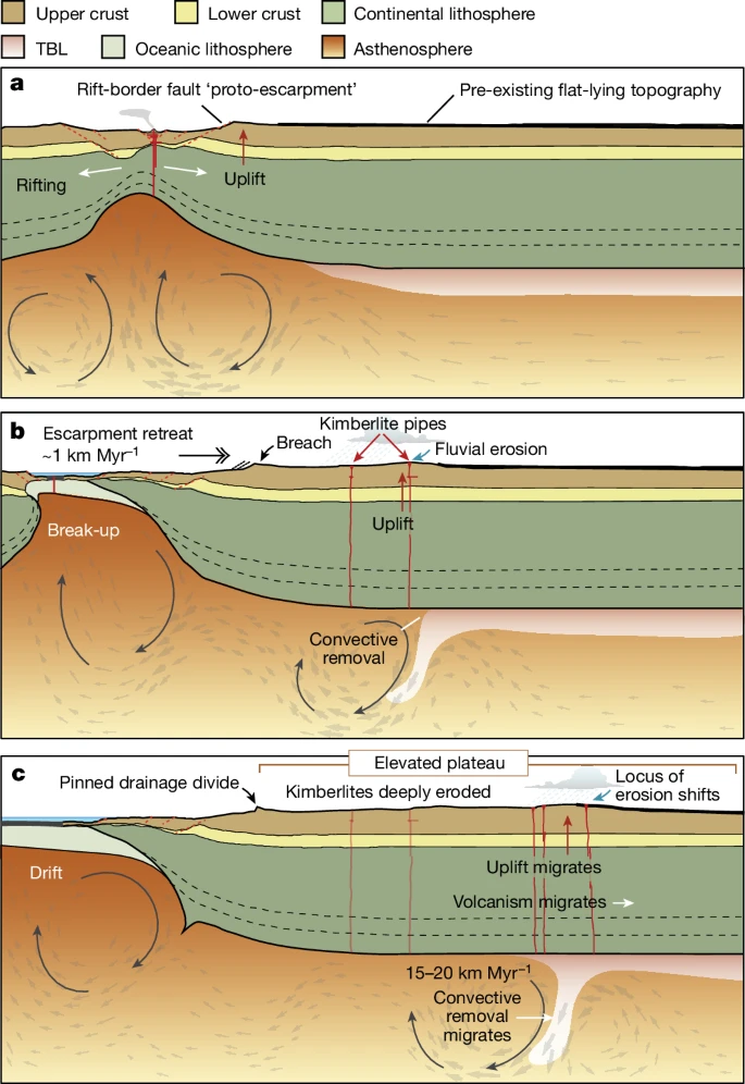
This ARTICLE, based on THIS PAPER in Nature, suggests that the splitting apart of a continental plate affects not only the area near the rift zone, but also the interior of the continent. 30 or 40 km of the roots of the continent are stripped away and this wave of root erosion moves towards the interior of the craton. And this results in an increase in altitude of the land surface.

I always thought that high land required deep roots - think of the deep crust below the Tibetan plateau. Here the suggestion is that the removal of roots allows the land to rise, like a baloon rising when the sandbags are thrown overboard.

The example cited is the Drakensberg of South Africa. This, and similar, if less impressive formations, form escarpments around the cratons formed at the breakup of Gondwana. The paper suggests that the coastal escarpments of Brazil and the Western Ghats of India have a similar origin.


a, Rifting causes edge-driven convection in the mantle, rift-flank uplift and escarpment formation. b, Rayleigh–Taylor instability migrates along the lithospheric root, resulting in convective removal of the TBL of the lithospheric keel, driving kimberlite volcanism11, isostatic uplift and denudation. c, Escarpment becomes a pinned drainage divide that is locally breached by the main rivers draining the plateau. Meanwhile, the convective instability continues to migrate towards the continental interior, leading to isostatic uplift, a shift in the locus of erosion and plateau formation (Fig. 4).

The authors believe that they explain why the interior of the cratons is so high and also the occurrence of kimberlites.

This is a very complex subject and I do not pretend to understand much of the arguments but read the papers and come to your own conclusions.

Down to Earth Extra September 2024

 Down to Earth Extra September 2024

The September 2024 edition of Down to Earth Extra has been published. You can download it HERE or you can red it below.


Thursday, 15 August 2024

Orcadian Basin Rock at Stonehenge!

 Orcadian Basin Rock at Stonehenge!

I expect you all have heard that the Altar Stone at Stonehenge has been proved to be from the Old Red Sandstone (ORS) of North East Scotland. The original paper is in Nature and can be read HERE


The Altar Stone, seen here underneath two bigger Sarsen stones, which new research suggests is actually Scottish not Welsh © Professor Nick Pearce/PA Wire

Nature has also provided a video which is well worth viewing.


The origen has been established using extremely sophisticated analysis techniques on individual crystals in a couple of thin sections. These proved that the zircon, rutile and apatite crystals present (and there were not many of them!) could only come from the Orcadian Basin. The Nature paper goes into excruciating detail on this, but it is summed up in the following figure.


How the stone got to Stonehenge will, no doubt, lead to furious debate. Tha Nature article posits that it was "anthropogenically transported"! What I find more interesting is why the builders of Stonehenge thought that a stone from so far away was necessary for the site.


Mantle Drilled

 Mantle Drilled

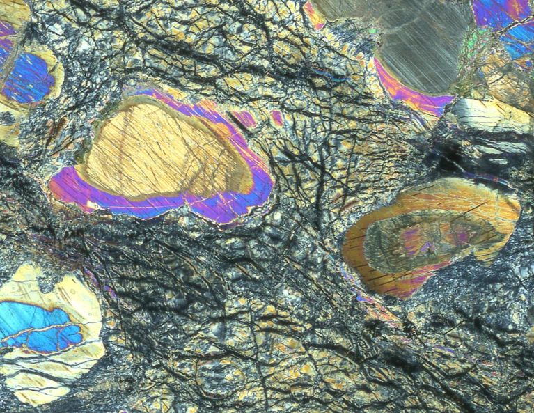
Several sources have alerted me to this item of news. The longest core sample of the mantle (1,286m) has been drilled and will soon be available for examination. It was drilled by the well known drill ship "Joides Resolution" in the North Atlantic near the Mid-Atlantic Ridge, and not far from the Lost City hydrothermal field, which is also well known.

You can read all about it HERE (Nature), HERE (Science) and HERE (The Conversation). What you can read is that it is serpentinized abyssal mantle peridotite interleaved with thin gabbroic intrusions. Other than that they have little to say because, as yet, little has been done with the core. No doubt that will change!


A sample of mantle rock viewed under a microscope.Credit: Johan Lissenberg

Tuesday, 6 August 2024

Phosphorus Presence Leads to Macrofossils?

 Phosphorus Presence leads to Macrofossils?

It is thought that the lack of phosphorus (P) was what stopped the evolution of unicellular life into complex life in the Pre-Cambrian. The increase in P allowed the Ediacarian and Cambrian fossils to evolve.

In Gabon, the 2100 Ma Paleoproterozoic Francevillian formation, due to peculiar circunstances had high phosphorus (and other element) concentrations. And there are structures which have been interpreted as macrofossils.

Did complex life start 1500 Ma before the Ediacarian and Cambrian? If it did, it was a false start as the peculiar conditions ended and life resumed it unicellular course until the Ediacarian.

As you can imagine, there is much controversy about this. You can see examples of the suspected biota HERE. Some say they are colonial organisms, others that they are not.

You can read all about it HERE. This based on THIS PAPER.


The Fraceville "biota". Are they fossils or are they something else?

Saturday, 27 July 2024

Cave Man in the Moon?

Cave Man in the Moon?

In the last few weeks there has been some speculation about the existence of caves (or, more likely, lava tubes) on the Moon and their suitability as good places to live on the satellite. See HERE and HERE.

The data from which the caves were recognised was gathered in 2010 but it is only recently that processing techniques advanced enough for the presence of the caves to be recognised.

The surface of the Moon is not a good place to live for any length of time. There is no atmosphere or magnetic field to protect life from cosmic radiation. But a cave under several tens of metres of rock would be a very good protection.

All this is an indication that man will be returning to the moon in the forseeable future.

Down to Earth Extra August 2024

Down to Earth Extra August 2024

The August 2024 edition of Down to Earth Extra has bee published. You can download it HERE or you can read it below.


Thursday, 25 July 2024

Oxygen - is Sunshine Needed?

Oxygen - is Sunshine Needed?

Geologists used to think that free oxygen is the result of life, cholesterol and sunshine. But THIS ARTICLE suggests that we will have to change our ideas. The article is based on THIS ACADEMIC PAPER in Nature Geoscience.

The authors discovered an increase of oxygen concentration with depth while studying metallic nodules on the bed of the Pacific. These nodules contain "interesting" (i.e profitable) metallic elements and there is pressure to mine them.

The authors were commisioned to studt the impact that mining would have on the seafloor ecosystem. Part of their study was to look at oxygen levels. They expected to find a decline with depth. They discovered the opposite and that the oxygen was coming from the nodules.

The mechanism of oxgen production is thought to be electrolysis of seawater caused by potential difference between metal ions within the nodules.

This newly discovered source of oxygen may lead to a rethink of biological evolution and the oxygenation of the Earth!

What it does to the prospects of deep sea mining promises to be interesting.


So-called polymetallic nodules are potato-size lumps of oxides of iron and manganese that also contain precious metals like cobalt and rare earth elements. (Image credit: NOAA Office of Ocean Exploration and Research, 2019 Southeastern U.S. Deep-sea Exploration)

Thursday, 18 July 2024

What is the Younger Dryas?

What is the Younger Dryas?

I stumbled upon THIS ARTICLE and was impressed by its clarity in describing the Younger Dryas. I knew that the Younger Dryas existed but I must have missed the lecture when it was defined. And I was vaguely aware that there was some controversies associated with it.

The Skeptoid web site specialises in debunking the fake science which proliferates on the internet and is well worth supporting - and you get clear descriptions of the Younger Dryas!

Saturday, 6 July 2024

Heart of Wales Geopark Opening

 Heart of Wales Geopark Opening

On 27th July the "Heart of Wales Geopark will open. The details are contained in the poster which you can read below or download HERE.


Down to Earth Extra July 2024

  Down to Earth Extra July 2024

The July 2024 edition of Down to Earth Extra has been published. You can download it HERE or you can read it below.


Saturday, 29 June 2024

The Best Preserved Trilobites

The Best Preserved Trilobites 

The New Scientist magazine has THIS ARTICLE which is based on the discovery of some remarkably well preserved Cambrian trilobites in Morocco. The original article can be found HERE. Full access is behind a pay wall but you can download a PDF, from the same page, which contains a huge amount of detail, including maps, illustrations and references.

The trilobites were preserved through rapid ash burial in a pyroclastic flow entering a shallow marine environment.


This fossil shows the digestive system (blue), the hypostome (green), the labrum (red) and selected appendages

Arnaud Mazurier/University of Poitiers

The finest details of its exterior and interior have been preserved. The illustration below gives you some idea of the level of detail.


Tour de France Geology

 Tour de France Geology

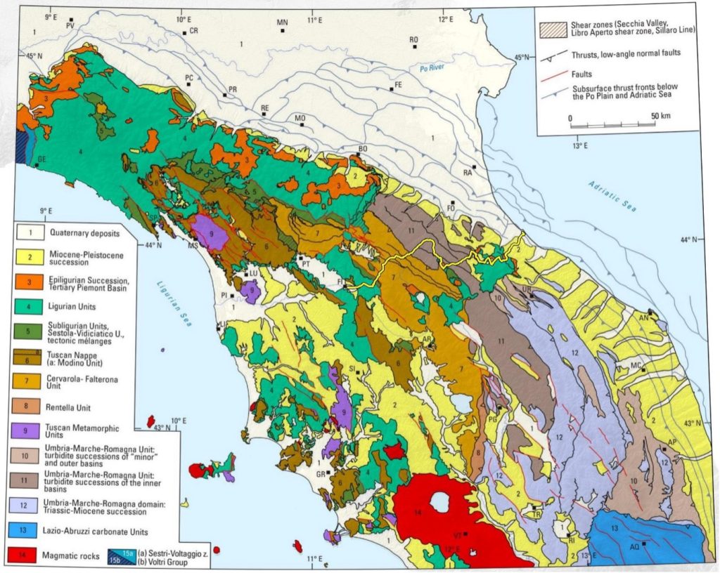
Some of you may be aware that the Tour de France starts today - Saturday 29th June. One of the joys of following it is looking at the scenery, especially the views from the hovering helicopters. And often the geology is intriguing. A correspondent brought THIS WEBSITE to my attention. This will be giving a geological perspective to each stage.

Just to be contrary, this year the Tour starts in Florence, Italy and the web site talks about the tectonics of the Appenines. THE ARTICLE for today is written by someone who knows what she is talking about and she gives references for further reading. 

Each day of the Tour has a different geological topic and a different author. I hope they will all be so informative.


Tectonic units of the Northern Apennines with indicated buried faults (Figure from Conti et al., 2020). The course of stage 1 in yellow.

Friday, 21 June 2024

Is Geological Research Becoming Less Interesting?

 Is Geological Research Becoming Less Interesting?

Over the last while I have been floundering to find things to put in the blog. There has still been a lot of local geological happenings which I am always pleased to highlight, but there has been a dearth of other stuff.

I thought this was just me not looking hard enough but then I came across THIS ARTICLE from a man who has been the source of many of the articles I have published. And he says the same! Why this should be so, neither he or I can think of a good reason. Let us hope it is just a passing phase.

I hope he (and I) find some interesting articles soon. If you came across something notable, let me know and it will appear here.

Friday, 14 June 2024

Madygen - a Possible Future Excursion?

 Madygen - a Possible Future Excursion?

I came across THIS ARTICLE in New Scientist because I was seeing many photos of colourful rock strata, most of which looked as if they had been "improved" greatly - see the two examples below - they are photos of the same place!


Eventually I found the following photo which seems relatively untouched by Photoshop.


The accompanying article was equally interesting. It concerns the attempt to get the Madygen area declared a Geopark. Madygen is in Kyrgyzstan and was once part of the USSR.

Geologically the area has a lot going for it - rocks, fossils, a fascinating geological history. It is everything else which is going to make things difficult. If you thought the North West Highlands was remote, this part of Kyrgyzstan is (almost) out of this world. 

To be recognised by UNESCO, a Geopark must have tourist infrastructure, including trails, information signage and places to stay nearby. The Batgen Region of Kyrgyzstan, where Madygen is, is the poorest of the country and almost everything is not there!

And to make things worse, most of the geological knowledge of the area is held in the Russian Academy of Sciences in Moscow.

I hope that the area becomes a Geopark but I suspect it will be a few years before I will be advertising excursions to the area.


Saturday, 8 June 2024

Down to Earth Extra June 2024

 Down to Earth Extra June 2024

The June 2024 edition of Down to Earth Extra has been published. You can download it HERE or you can read it below.


Saturday, 25 May 2024

Mammoths in the Cellar

 Mammoths in the Cellar

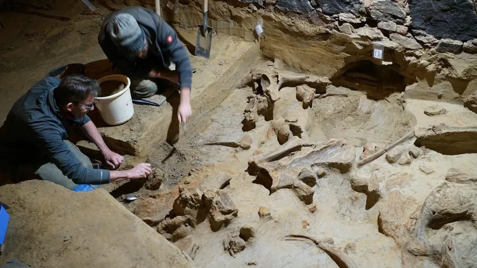
A correspondent sent me a link to THIS ARTICLE. It concerns an Austrian winemaker who was renovating his wine cellar when he discovered the bones. The researchers called in, date the bones to 30 to 40 thousand years old and think they may have been hunted by early humans.

And they are very excited by it as they are able to use modern techniques to investigate them.

I got the link while exploring wine cellars in the Southern Rhone but what I found was in a different area of interest.


Wednesday, 15 May 2024

GeoWeek 2024 on Ham Hill - May 25 - June 2

 GeoWeek 2024 on Ham Hill

A correspondent has sent me details of the events on Ham Hill from May 25th to June 2nd. You can read all about them below.
--------------------------------------

25-26 May Learn the art and craft of dry stone walling
Together with a little geology, through hands-on experience of the unique Ham Hill


Limestone.
Cost £100 for the weekend
Booking essential
Contact:
 South West England Dry Stone Walling Association (SWEDSWA) for more details and booking arrangements.


30 May 10:00am-11:30 Fossil Fun
More details
Cost £6.00 per child
Aimed at families with children aged 4-9. All children must be accompanied by an adult at all times, accompanying adult free (max 2 adults per child).
More details:


Please email countryside@somerset.gov.uk with the number of places you require and a contact phone number.  We will check the availability and confirm your place. Payment needs to be made by cash on the day please. We will respond to all emails, please check ‘junk mail’ if you haven’t received a reply.

1 June 10:30am-3:30pm: The Geology of Ham Hill Guided Walk

Following a brief introduction to the geology of the region, an opportunity to explore one of the best inland geological locations in Somerset.
Expansive views over the Somerset landscape, sculpted by the environmental upheavals of the past 400 million years.


We’ll then visit the Yeovilian Substage of the Early Jurassic, around 177 million years ago, as exposed in a number of disused quarries in the Ham Hill Limestone. These include a nationally important geological Site of Special Scientific Interest (SSSI) together with a number of Local Geological Sites. 

We’ll also consider how the geology has underpinned the archaeology, history, industry, agriculture, and biodiversity of Ham Hill – and how our volunteers are working to conserve our geoheritage.

Cost £2.00 per adult
Supported by National Heritage Lottery Fund

Booking essential

Please email countryside@somerset.gov.uk with the number of places you require and a contact phone number.  We will check the availability and confirm your place. Payment needs to be made by cash on the day please. We will respond to all emails, please check ‘junk mail’ if you haven’t received a reply


Any time: Self-guided walk along the Ham Hill Geology Trail.
See below. Leaflet also available from outside the Ham Hill Centre and Rangers Office, Ham Hill Road, Stoke-sub-Hamdon, Somerset TA14 6RW


[View/Download]


Part of GeoWeek 2024 Active Geoscience https://earth-science.org.uk/geoweek/


----------------------------------------------

Monday, 29 April 2024

FROME INTERNATIONAL CLIMATE FILM FESTIVAL 2024 - BE INSPIRED

 FROME INTERNATIONAL CLIMATE FILM FESTIVAL 2024 - BE INSPIRED

Simon Carpenter has asked me to advertise this and I am happy to oblige. 

--------------------------------------

FROME INTERNATIONAL CLIMATE FILM FESTIVAL 2024 - BE INSPIRED

Sun 19 May 2024 9:00 AM - 11:30 PM

The Cheese and Grain in Frome, Somerset BA11 1DS

The Frome International Climate Film Festival, now in its 3rd year is being held in the Cheese and Grain in Frome, Somerset on the 19th May. Doors will open at 09.00 and close at 23:30.

This year the FREE festival will include even more inspiring films being screened all day plus we will have a family focused morning with Eco-Arts and activities for children, Technology Zone, Knowledge Cafe, Sensory Zone, Music and Movement Zone, Workshops plus Walks and Talks by the River.

We then end the day with the red-carpet Frome International Climate Film Awards celebration and the Post Awards Party with local award winning bands.

It is a festival for all interested in the Life, our Future, Community, Climate, Nature and the Environment. Let’s connect, share, support and inspire green change together we can change the world. 

For more details, visit this link:


----------------------------------------------------------

Saturday, 27 April 2024

Two, One Day Field Courses in June, with Nick Chidlaw

 Two, One Day Field Courses in June, with Nick Chidlaw

Nick Chidlaw is proposing two Field Course in June which sound rather interesting. Nick gives the details below.

----------------------------------------------

I am offering two 1-day field courses to be run in June, if there is sufficient interest and enrolments to make them viable. 

These courses are independent of one-another  - you can enrol on either or both, according to your interest and availability. 

The courses are being offered on the same weekend: some people who live a substantial distance away may be interested in both courses and this would make attending them more workable. 

Hope you find these proposals of interest, and to hear from you soon.

Nick Chidlaw 
--------------------------

Title:  IMPROVED EXPOSURES AT KEY SITES WITHIN THE LATE PRECAMBRIAN MALVERNS COMPLEX

Saturday 22nd June  10.00 am - 5.00 pm

In the south west English Midlands the main ridge of the Malvern Hills forms a dramatic feature, particularly when viewed from the much lower country to the east. The main ridge is orientated north-south, narrow, and about 8 miles long; it reaches 425m above sea level; lower parts of the Hills lie to the west. 

The types of rocks and their age here are (un)usual (my correction) for southern Britain. Most of the main ridge is composed of rocks formed late in Precambrian times, between c. 680 - 670 million years ago, during the Cryogenian period. These rocks are referred to collectively as the Malverns Complex, and they comprise an almost bewildering variety of metamorphic types, colourfully-patterned, and exposed in numerous old quarry workings and natural crags. They have drawn the interest of geologists for generations. The Malverns Complex is understood to have formed during a tectonic plate collision, and when the southern British crust was located in the southern hemisphere about 60 degrees from the equator; the climate was cold and the plate collision zone likely had numerous snow- and ice-covered active volcanoes. The Complex itself was formed far below in the depths of the crust, where a succession of magmas were forming, cooling and crystallising, and becoming altered by continuing episodes of plate compression.  These rocks were subsequently uplifted and their overlying rocks eroded away, exposing them on the present land surface.

The Hereford & Worcester Earth Heritage Trust has for many years operated to record, conserve and promote the geology of the county. Recently, it has undertaken clearance of vegetation and pressure-cleaning of a number of key exposures in the Malverns Complex, in order for the rocks to be better studied and understood, at all levels of education.. This proposed course looks at some of these exposures, while the clearance work remains at its best.         

No prior geological knowledge or of the study area would be assumed. 

Tuition fee: £32.00

Contact tutor Dr Nick Chidlaw nickchidlaw@gmail.com to enrol and for any queries. 

Deadline for course viability: Friday 10th May. If the course has become viable (minimum 10 enrolments) by this date, enrolments will be able to continue until 1 week (Saturday 15th June) before the course runs.  


Image: part of Dingle Quarry in the Malvern Hills. The rock faces have recently been cleared of vegetation and exposures improved. The rocks include sheets of mafic and felsic igneous rocks within a diorite host, shearing is evident.  

-------------------------------------------------------

Title: STUDY THE NEW RED DESERT 

Sunday 23rd June 10.00 am - 5.00 pm. The course includes an exposure dependent on tides; the date and times have been chosen to include safe access.   

This course looks at locations in the NW of Gloucestershire where can be found strata that are part of the 'New Red Sandstone Supergroup'; they were deposited in a variety of environments under a tropical arid climate during the Permian and Triassic periods between c. 300 - 200 million years ago, when Britain lay just N of the equator. We look at exposures of rocks interpreted as being laid down as desert dunes, in seasonal braided rivers and lakes, in estuaries and on coastlines. Reference is made to alluvial fan deposits (not included in the itinerary due to accessibility problems) also present in the area. Marine incursions into this desert environment were initially absent, but became  increasingly common over time.  

No prior geological knowledge or of the study area would be assumed. 

Tuition fee: £32.00

Contact tutor Dr Nick Chidlaw nickchidlaw@gmail.com to enrol and for any queries. 

Deadline for course viability: Friday 10th May. If the course has become viable (minimum 10 enrolments) by this date, enrolments will be able to continue until 1 week (Sunday 16th June) before the course runs.  


Image: part of the cliff of the River Leadon near the village of Red Marley D'Abitot, exposing fluviatile deposits of the Helsby Sandstone Formation (Early / Middle Triassic). 
------------------------------------------