Saturday, 18 July 2026

Oceanic-plate Volcanism
Oceanic-plate Volcanism

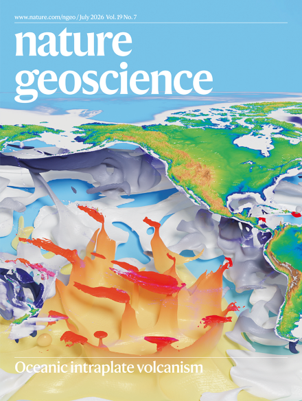
The latest edition of NATURE GEOSCIENCE has several papers on the volcanism found on oceanic plates. This includes seamounts and vast drowned plateaus. The seamounts are often found in chains, but not every sea mount is in a chain. The magazine has a rather nice cover illustration.


This issue of Nature is reviewed in Earth-logs which has a more extensive version of the Nature cover.


3-D simulation of geodynamics beneath the Pacific and Indian Ocean floors. Credit: Hao Dong, Institute of Geology and Geophysics, Chinese Academy of Sciences.

The latest edition of Geology Bites - a podcast about all things geological - also focuses on seamounts, especially those in chains. The scientist interviewed is Bernhard Steinberger. I recommend looking at the website as well as listening to the podcast.

So there is a lot of interest in this subject at the moment. And I wish I could give a simple explanation of the conclusions of all this work.

I can't, but my minion, Google Gemini can! The Nature papers can be summarised as follows:-

--------------------------------------

For decades, geologists used a simplified, step-by-step approach to map the Earth: volcanoes form over static "hot spots," plates move at ridges, and sink at subduction zones. However, recent studies published in Nature Geoscience show that the deep Earth is far more interconnected, messy, and dynamic than previously thought.

The key takeaways from the new research include:

"Seamount Breweries": Scientists used to think underwater volcanoes (seamounts) only formed in neat lines as a tectonic plate moved over a single, stationary "hot spot." However, most seamounts are scattered randomly. A new 290-million-year computer simulation explains why: massive, rising blobs of heat from deep near the Earth's core break apart as they hit the upper mantle. This creates wide, drifting "hot zones" that act like "breweries," popping up clusters of random volcanoes over time.

Deep Earth Launchpads: Volcanoes are much more common on ocean floors that have drifted over huge, super-hot structures at the very bottom of the Earth's mantle (called LLSVPs). These deep structures act like permanent engines launching heat upward.

The Connected Domino Effect: Massive volcanic plateaus, like the Ontong Java Plateau in the Pacific, didn't just form from a simple hot plume. New models suggest that about 130 million years ago, a sudden increase in plates sinking (subducting) around the edges of the Pacific Ocean forced the Earth's interior to rearrange. This slowed down sea-floor spreading at the ridges, forcing intense heat to escape elsewhere—melting dense, old crust deep down and pouring out unprecedented amounts of magma onto the deep ocean floor.

The Big Picture Change:
Geology is moving away from looking at isolated puzzle pieces. Instead, scientists now view the entire planet as a single, connected web where a change in one area (like a sinking tectonic plate) instantly triggers a massive reaction somewhere else (like a giant underwater volcanic eruption thousands of miles away).

------------------------------------------

And the Geology Bites podcast can be reduced to:-

-------------------------------------------

In this Geology Bites podcast episode, geophysicist Bernhard Steinberger discusses whether mantle hotspots (the deep plumes of hot rock that feed volcanic chains like Hawaii) are truly stationary.

His research and modeling lead to several key conclusions about mantle dynamics, plate tectonics, and how we map ancient Earth:

1. Hotspots Are Not Fixed

For decades, scientists assumed hotspots were stationary anchors that could be used as a fixed frame of reference to measure tectonic plate movement. Steinberger’s core conclusion is that hotspots actively move. They are bent and blown sideways (advected) by the massive mantle convection currents they must rise through—similar to smoke bending in a breeze.

2. The Famous "Hawaiian-Emperor Bend" Required Two Things

The striking, sharp 60-degree bend in the Hawaii-Emperor seamount chain (formed around 47 million years ago) was long thought to be caused solely by a sudden change in the Pacific plate's direction. Paleomagnetic data and Steinberger’s models show a dual reality:

  • The Hawaii hotspot itself was drifting rapidly southward (at about 3.5 cm per year) before 47 million years ago and then slowed or shifted.

  • The sharpness of the bend required both a change in plate motion and a change in the hotspot's own drift coinciding at the same time.

3. Hotspots Move Independently

Hotspots do not move together as a rigid grid. Each one drifts at its own speed and direction (typically around 1 cm per year) depending on its local mantle environment. For example, while the Hawaii hotspot was moving southward, its South Pacific neighbor, the Louisville hotspot, was drifting slowly eastward. This independent movement is the definitive proof that they are not fixed relative to each other.

4. Why Hotspots Stay Relatively Anchored

Despite this movement, hotspots change position slowly enough to still be highly useful. Whole-mantle seismic tomography reveals why: the plume conduits are incredibly thick (several hundred kilometers across) and rooted in dense, sluggish thermochemical piles (LLSVPs) right at the core-mantle boundary. Because the lower mantle moves so slowly, the roots of these plumes stay relatively stable.

5. A "Moving Hotspot Reference Frame" is Necessary

Because we cannot treat hotspots as completely stationary, geophysicists must use Steinberger's mantle-flow models to calculate past hotspot drift. By factoring in this drift alongside paleomagnetic data (which tracks a plate's latitude relative to Earth's spin axis), scientists can establish a more accurate "moving hotspot reference frame" to reconstruct how tectonic plates moved relative to the deep mantle over hundreds of millions of years.

6. The Whole Lithosphere Drifts Westward

When you sum up the total movement of all tectonic plates within this deep-mantle reference frame, the entire outer shell of the Earth (the lithosphere) exhibits a net westward rotation of about 1.5 cm per year at the equator. Steinberger concludes that this isn't caused by tidal forces from the Moon, but is simply driven by the massive Pacific plate being dragged rapidly westward by subduction zones along its edges.

------------------------------------


Friday, 17 July 2026

Sea Floor Spreading Observed!

 Sea Floor Spreading Observed!

A correspondent has sent me THIS LINK. It records what people thought must be happening but which no one had actually measured! 

It is the result of the installation of measuring equipment on the axis of the Southeast Indian Ridge (SEIR) - a mid Ocean ridge - and on the Amsterdam transform fault (TF). Both are not very far from Amsterdam Island. This is one of the most inaccessible places on Earth. It is about mid way between Western Australia and South Africa. To the south is Antarctica.

The article goes into a vast amount of detail which I will not attempt to interpret. Google Gemini was asked to rewrite the abstract in easy to understand language and came up with the following:-

Scientists have captured a rare, up-close look at the ocean floor literally tearing itself apart and forming new crust.

Because mid-ocean ridges (underwater mountain ranges where tectonic plates pull apart) are buried deep underwater, they are incredibly hard to monitor. However, researchers had equipment perfectly placed in the Indian Ocean to catch a massive "rifting event" right as it started on April 26, 2024.

Here is what happened over the span of about 16 days:

  • The Ground Opened Up: An underground magma chamber deflated, sending channels of liquid rock (called dykes) bursting sideways through the ridge.

  • The Sea Floor Shifted: The valley floor sank by 4 meters (about 13 feet) and widened by more than a meter.

  • A Massive Eruption occurred: The magma broke through the surface, spilling roughly 160 million cubic meters of lava onto the ocean floor.

  • Silent Earthquakes Cleared a Mystery: Tectonic plates usually move with a lot of shaking, but this event triggered a lot of "aseismic slip"—meaning the ground slid smoothly without causing measurable earthquakes.

Why this matters: Scientists have always wondered why mid-ocean ridges have far fewer earthquakes than expected. This discovery suggests that underground magma movements actually lubricate the faults, letting the tectonic plates slide past each other quietly and smoothly rather than violently snapping.

Saturday, 4 July 2026

Studying the Hadean is Difficult!

Studying the Hadean is Difficult!

For a start there is not much of it! Perhaps 20km² on Hudson Bay. Most studies have concentrated on zircon grains found in younger rocks. The best that can be said is that there was felsic magma and water was about. 

But there are other approaches. The early Earth was characterised by impacts from space, but direct evidence of these is missing on the Earth. The surface of the moon however records these and scaling up to the size of the Earth indicates that they would have a major influence on the Hadean on the Earth.

This is considered in THIS ACADEMIC PAPER and is summarised in this ARTICLE. The conclusion reached is that the heat produced from the kinetic energy of the impacts would have made almost everything start to melt. Below 3.5km lots of rocks of all kinds would be melting. Above 3.5km heat loss to space would keep things relatively cool.

The Earthlogs article is well worth reading. It may be easier to understand if you read the following summary produced by Google Gemini.

The Hadean Eon (~4.6 to 4.0 billion years ago) lacks a substantial rock record, leaving geologists to rely heavily on the geochemical signatures of rare, tiny zircon grains. To shed light on this elusive era, researcher Tim Johnson and his colleagues modeled the impacts of heavy celestial bombardment on the early Earth, scaling up lunar cratering data to account for Earth's greater gravitational pull.

The study reveals that during the Hadean, the energy released by frequent asteroid impacts significantly outweighed internal radiogenic heat generation. This intense, fluctuating external energy profoundly altered Earth’s thermal dynamics. Rather than shedding heat through modern plate tectonics and mantle convection, the Hadean Earth relied on massive, rapid melting events. Magma transported immense heat directly to the surface, allowing energy to radiate into space—the most efficient planetary cooling mechanism.

The team’s modeled geotherm indicates that temperatures increased rapidly with depth. Beneath a depth of just 3.5 kilometers, the uppermost Hadean crust was in a partially molten state. At depths exceeding 10 kilometers, between 40% and 70% of basaltic crust would have been liquefied. This pervasive melting effectively nullified the traditional distinction between brittle and ductile rock behaviors.

Consequently, the simulation rules out the existence of a rigid lithosphere or stabilizing plate tectonics during this period. Instead, the Hadean mantle was dominated by chaotic, high-energy convection. This continuous recycling of early granitic and continental crust into a literal melting pot perfectly explains the near-total absence of intact Hadean rocks today. This volatile cycle of impact-driven tectonics only ceased around 3.9 to 3.8 billion years ago, when the heavy bombardment subsided and allowed stable, modern planetary geology to emerge.