Saturday, 26 September 2026

The Handedness of Forams

The Handedness of Forams

I learned a new word today - chirality - which is defined as - The property of handedness or asymmetry that is not superimposable on its mirror image.

And I learned this from THIS ARTICLE, sent to me by a correspondent. The article discusses, at some length and with nice illustrations, the phenomena that some species of forams coil in a clockwise or anti-clockwise style. And in any one species the coiling is almost always in one direction or the other. Even more mysteriously the direction of coiling flips to the other direction - and this occurs all over the world and - as far as stratigraphers are concerned - instantaneously!


These fossils from the extinct foram Globorotalia limbata, which lived 11 million to 2 million years ago, illustrate right- and left-handed chirality in shell coiling.

Read the article and you will find that it comes to the conclusion that an advantageous mutation in a small subpopulation of forams occurs, and it has the different coiling direction. It outcompetes its forbears and rapidly spreads across the world. Which sounds very ordinary and not at all miraculous!

The article is very readable, but if you are pressed for time, here isa summary produced by Google Gemini.

-----------------------------
For millions of years, tiny single-celled ocean organisms called foraminifera (forams) have built microscopic, snail-like coiled shells. In many species, nearly the entire population coils its shell in the same direction—either left or right. However, the fossil record reveals a bizarre mystery: every few thousand years, entire global populations of certain foram species suddenly flip their shell direction all at once, only to flip back again millennia later.

For decades, scientists believed environmental factors caused these flips. A popular theory suggested that water temperature dictated coiling direction, with cold ice-age waters favoring left-handed spirals and warmer periods favoring right-handed ones.

However, recent genetic discoveries and comprehensive global studies led by micropaleontologists like Bridget Wade have disproven the simple temperature theory. Researchers found that these shell flips occurred simultaneously across completely different ocean environments, latitudes, and climate zones worldwide, ruling out local environmental changes as the cause.

Instead, scientists now propose that the flipping motion is not a direct adaptation to climate, but rather an accidental evolutionary footprint. Ocean populations often harbor "cryptic species"—microorganisms that look identical under a microscope but are genetically distinct. The new hypothesis suggests that a advantageous mutation arises in a small subpopulation of forams that happens to coil in the opposite direction. As this new genetic group outcompetes others and rapidly spreads across the world's ocean basins, its coiling preference quickly becomes the new global standard.

Ultimately, these mysterious shell flips provide paleobiologists with a rare visual window into how hidden genetic traits and new species can sweep across the planet over geological time.
--------------

Update on the Oblate Spheroid

 Update on the Oblate Spheroid

A correspondent sent me a link to THIS MAGAZINE ARTICLE. This, in turn, is based on THIS ACADEMIC PAPER. The articles are concerned with the shape of the Earth and the changes which are taking place to it.

When I went to University I was much interested in this and was amused to find that the north to south flowing Mississippi had its source closer to the centre of the Earth than its mouth, so it was flowing uphill!

But the author of the scientific paper has gone rather further into the problem than I did and has found that global warming is the cause - and it is accelerating. Ice has been removed from the poles so the Earths surface has risen. Meanwhile the melt water has moved to lower latitudes and depressed the Earth's surface. The rocky spheroid is becoming less oblate.

But the affect on the Earth's gravity is the opposite. Moving mass (water) to the equator makes the gravitational geoid more oblate!

I found this difficult to comprehend so used Google Gemini to summarise the academic paper - (this is long and very dense) - and it came up with this:-

-----------------------------

Summary of Mapping Global GNSS Vertical Velocities to Solid Earth Figure Change (Kotsakis, 2026)

A 2026 study published in the Journal of Geophysical Research: Solid Earth reveals that the physical shape of our planet is changing at an accelerating pace.

Earth is not a perfect sphere; it bulges slightly at the equator due to its rotation. However, using precise Global Navigation Satellite System (GNSS) tracking stations, geologist Christopher Kotsakis analyzed movement across Earth’s crust between 1997 and 2015. The findings show a clear global pattern: the polar landmasses are rising (uplift), while regions near the equator are sinking (subsidence). This ongoing movement means the solid surface of the Earth is gradually becoming slightly rounder and less flattened at the poles.

Between 1997 and 2000, polar regions were rising at a rate of roughly 0.5 millimeters per year. By 2015, that speed had doubled to about 1 millimeter per year, demonstrating an overall acceleration in surface deformation.

The primary driver behind this shift is the redistribution of water mass across the planet, largely fueled by climate change. As ice sheets and glaciers in places like Greenland and Antarctica melt, the immense weight pressing down on the polar crust lightens. Consequently, the rocky ground underneath springs back up (elastic rebound).

At the same time, all that melted ice flows into the global ocean network, adding heavy water weight to lower latitudes and causing the seafloor and equatorial regions to sink under the new load.

Interestingly, this creates a subtle paradox between Earth's physical ground and its gravitational field. While the rocky crust itself is becoming slightly rounder, the mass of water collecting around lower latitudes causes the planet's gravitational field to remain flattened. Overall, the study highlights how dynamic Earth's solid surface is in response to shifting climate and ocean dynamics.
--------------------------------

Thursday, 17 September 2026

Geol Soc Nightschool

 Geol Soc Nightschool

Want to find all about dinosaurs? Then go to THIS WEBSITE and let Mike Benton tell you all he knows - or at least quite a lot!

This a new venture by the Geol Soc. It will be live at 17:30 on the 21st October and will last for about 2 hours. It will not be recorded so you need to be online.

If you go to the link above you will find not only Mike Benton but lots of other educators teaching lots of geological topics. This should fill up your calendar until almost Christmas!

Saturday, 29 August 2026

Deep Down, Its Complicated

Deep Down, Its Complicated

A correspondent forwarded THIS LINK which is based on THIS JOURNAL ARTICLE. It concerns seismic waves created by the French nuclear tests in the South Pacific between 1977 and 1995. The records used were recorded in Kazakhstan. 

One would think that seismic waves created in one spot and recorded in another would be the same over time. After all they are travelling through the same stuff!

But no! Using waves which reflected inside the (liquid) outer core, the travel times varied over time. This leads to the conclusion that the outer core is dynamically changing. 

This is important as the outer core is responsible for generating the Earths magnetic field.

Both articles are quite complex but Google Gemini is able to give a fairly simple version of the papers. Here it is:-

-------------------------
A research study published in the Journal of Geophysical Research: Solid Earth (doi: 10.1029/2026JB033798) reveals that the deep interior of our planet is far more dynamic than long believed, challenging the traditional view that Earth’s outer core is a uniform, static ocean of liquid metal.

Led by Virginia Tech geophysicist Ying Zhou, researchers analyzed seismic data recorded during underground nuclear tests conducted by France at Moruroa Atoll in French Polynesia between 1977 and 1995. Subterranean nuclear explosions provide a unique advantage over natural earthquakes for geoscientists: because test detonations occurred at precisely known, nearly identical locations, they generated consistent seismic wave pathways through Earth’s deep interior. By analyzing 112 pairs of historic explosions, the team tracked microscopic variations in how long it took specific waves (known as PKrKP waves, which reflect within the outer core) to travel through the planet over several decades.

The findings indicate that the travel times of these deep-reaching waves changed measurably between test events. This shift points to a massive, previously unrecognized structure drifting within the molten outer core beneath the southern Pacific Ocean. Estimated to stretch roughly 700 kilometers across and 100 kilometers thick, this feature may consist of solid material suspended inside the churning liquid metal or localized density variations drifting as the core circulates.

These rapid, decade-scale shifts are significant because movement within the liquid outer core powers the geodynamo—the planet-wide engine responsible for generating Earth’s protective magnetic field. Understanding that massive structures can shift deep underground over just a few decades offers scientists a dynamic new model for how Earth’s core behaves, while demonstrating how legacy Cold War-era nuclear records can serve as unexpected time capsules for planetary science.
--------------------

Down to Earth Extra September 2026

 Down to Earth Extra September 2026

The September 2026 edition of Down to Earth Extra has been published. You can download it HERE or you can read it below.


Saturday, 8 August 2026

Down to Earth Extra August 2026

 Down to Earth Extra August 2026

The august 2026 edition of Down to Earth Extra has been published. You can down load it HERE or you can read it below.


Ichthyotitan severnensis - Finding a New Species

 Ichthyotitan severnensis - Finding a New Species

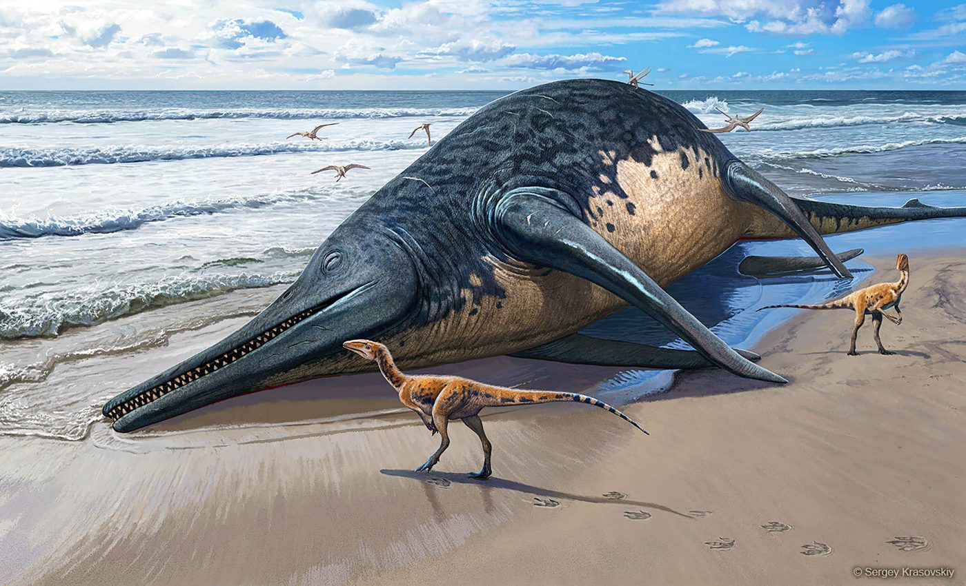
I came across this WEB PAGE and from it was directed to THIS ACADEMIC PAPER. The contrast between the styles is extreme but the basis for both is the same. This is the finding of bones from the jawbone of an ichthyosaur and using the finds to describe a huge creature and erect a new species.

The bones were found by a young girl and her father on Blue Anchor Bay in Somerset and the creature is estimated to be 25m long. It was realised that a similar jawbone had been found some time earlier in the same rock layer, at a nearby locale. This was sufficient for a new species to be postulated.


A washed-up Ichthyotitan severnensis carcass on the beach. Credit: Sergey Krasovskiy.

The story of the find shows that amateur geologists can still be important in our science. And it is cheering to note that they both appear among the authors of the academic paper.

The paper has a long description of the find and a discussion about the naming of a new species. And it asks that if you find something similar to contact them! And they would be delighted if you could find a complete specimen of the animal!

Saturday, 1 August 2026

Did Complex Life Appear Because the Magnetic Field was Weak?

 Did Complex Life Appear Because the Magnetic Field was Weak?

Some parts of the history of the Earth's magnetic field are easy to measure. But the strength of the field is not one of them. We have lots of information of the reversals of the polarity of the field and the direction of the magnetism - think of the stripes on the ocean floor and knowing the latitude of when rocks were laid down - but the field strength of the field is harder to come by.

And this is important for the presence of the field is what protects us from deadly cosmic rays. It is very possible that no field = no life.

But some measurements of field strength have been made and one of the interesting things is that it was very low in the Ediacaran. It was a fifteenth of the present value. This and the consequences of this are discussed in THIS ARTICLE.

Did the reduction in magnetic field strength allow more genetic mutation in the single-celled creatures promoting the multi-celled Ediacaran fauna?

The article goes on to discuss the mechanism which affected the field, essentially the formation of the Earth's inner core. The 100 million years this took covers the Ediacaran and the "Cambrian Explosion".

The article gives a pleasing combination of Earth physics and biology. It may even be true!

Saturday, 18 July 2026

Oceanic-plate Volcanism

Oceanic-plate Volcanism

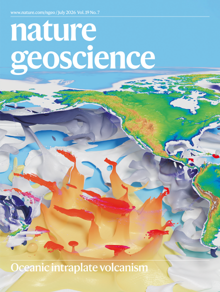
The latest edition of NATURE GEOSCIENCE has several papers on the volcanism found on oceanic plates. This includes seamounts and vast drowned plateaus. The seamounts are often found in chains, but not every sea mount is in a chain. The magazine has a rather nice cover illustration.


This issue of Nature is reviewed in Earth-logs which has a more extensive version of the Nature cover.


3-D simulation of geodynamics beneath the Pacific and Indian Ocean floors. Credit: Hao Dong, Institute of Geology and Geophysics, Chinese Academy of Sciences.

The latest edition of Geology Bites - a podcast about all things geological - also focuses on seamounts, especially those in chains. The scientist interviewed is Bernhard Steinberger. I recommend looking at the website as well as listening to the podcast.

So there is a lot of interest in this subject at the moment. And I wish I could give a simple explanation of the conclusions of all this work.

I can't, but my minion, Google Gemini can! The Nature papers can be summarised as follows:-

--------------------------------------

For decades, geologists used a simplified, step-by-step approach to map the Earth: volcanoes form over static "hot spots," plates move at ridges, and sink at subduction zones. However, recent studies published in Nature Geoscience show that the deep Earth is far more interconnected, messy, and dynamic than previously thought.

The key takeaways from the new research include:

"Seamount Breweries": Scientists used to think underwater volcanoes (seamounts) only formed in neat lines as a tectonic plate moved over a single, stationary "hot spot." However, most seamounts are scattered randomly. A new 290-million-year computer simulation explains why: massive, rising blobs of heat from deep near the Earth's core break apart as they hit the upper mantle. This creates wide, drifting "hot zones" that act like "breweries," popping up clusters of random volcanoes over time.

Deep Earth Launchpads: Volcanoes are much more common on ocean floors that have drifted over huge, super-hot structures at the very bottom of the Earth's mantle (called LLSVPs). These deep structures act like permanent engines launching heat upward.

The Connected Domino Effect: Massive volcanic plateaus, like the Ontong Java Plateau in the Pacific, didn't just form from a simple hot plume. New models suggest that about 130 million years ago, a sudden increase in plates sinking (subducting) around the edges of the Pacific Ocean forced the Earth's interior to rearrange. This slowed down sea-floor spreading at the ridges, forcing intense heat to escape elsewhere—melting dense, old crust deep down and pouring out unprecedented amounts of magma onto the deep ocean floor.

The Big Picture Change:
Geology is moving away from looking at isolated puzzle pieces. Instead, scientists now view the entire planet as a single, connected web where a change in one area (like a sinking tectonic plate) instantly triggers a massive reaction somewhere else (like a giant underwater volcanic eruption thousands of miles away).

------------------------------------------

And the Geology Bites podcast can be reduced to:-

-------------------------------------------

In this Geology Bites podcast episode, geophysicist Bernhard Steinberger discusses whether mantle hotspots (the deep plumes of hot rock that feed volcanic chains like Hawaii) are truly stationary.

His research and modeling lead to several key conclusions about mantle dynamics, plate tectonics, and how we map ancient Earth:

1. Hotspots Are Not Fixed

For decades, scientists assumed hotspots were stationary anchors that could be used as a fixed frame of reference to measure tectonic plate movement. Steinberger’s core conclusion is that hotspots actively move. They are bent and blown sideways (advected) by the massive mantle convection currents they must rise through—similar to smoke bending in a breeze.

2. The Famous "Hawaiian-Emperor Bend" Required Two Things

The striking, sharp 60-degree bend in the Hawaii-Emperor seamount chain (formed around 47 million years ago) was long thought to be caused solely by a sudden change in the Pacific plate's direction. Paleomagnetic data and Steinberger’s models show a dual reality:

  • The Hawaii hotspot itself was drifting rapidly southward (at about 3.5 cm per year) before 47 million years ago and then slowed or shifted.

  • The sharpness of the bend required both a change in plate motion and a change in the hotspot's own drift coinciding at the same time.

3. Hotspots Move Independently

Hotspots do not move together as a rigid grid. Each one drifts at its own speed and direction (typically around 1 cm per year) depending on its local mantle environment. For example, while the Hawaii hotspot was moving southward, its South Pacific neighbor, the Louisville hotspot, was drifting slowly eastward. This independent movement is the definitive proof that they are not fixed relative to each other.

4. Why Hotspots Stay Relatively Anchored

Despite this movement, hotspots change position slowly enough to still be highly useful. Whole-mantle seismic tomography reveals why: the plume conduits are incredibly thick (several hundred kilometers across) and rooted in dense, sluggish thermochemical piles (LLSVPs) right at the core-mantle boundary. Because the lower mantle moves so slowly, the roots of these plumes stay relatively stable.

5. A "Moving Hotspot Reference Frame" is Necessary

Because we cannot treat hotspots as completely stationary, geophysicists must use Steinberger's mantle-flow models to calculate past hotspot drift. By factoring in this drift alongside paleomagnetic data (which tracks a plate's latitude relative to Earth's spin axis), scientists can establish a more accurate "moving hotspot reference frame" to reconstruct how tectonic plates moved relative to the deep mantle over hundreds of millions of years.

6. The Whole Lithosphere Drifts Westward

When you sum up the total movement of all tectonic plates within this deep-mantle reference frame, the entire outer shell of the Earth (the lithosphere) exhibits a net westward rotation of about 1.5 cm per year at the equator. Steinberger concludes that this isn't caused by tidal forces from the Moon, but is simply driven by the massive Pacific plate being dragged rapidly westward by subduction zones along its edges.

------------------------------------


Friday, 17 July 2026

Sea Floor Spreading Observed!

 Sea Floor Spreading Observed!

A correspondent has sent me THIS LINK. It records what people thought must be happening but which no one had actually measured! 

It is the result of the installation of measuring equipment on the axis of the Southeast Indian Ridge (SEIR) - a mid Ocean ridge - and on the Amsterdam transform fault (TF). Both are not very far from Amsterdam Island. This is one of the most inaccessible places on Earth. It is about mid way between Western Australia and South Africa. To the south is Antarctica.

The article goes into a vast amount of detail which I will not attempt to interpret. Google Gemini was asked to rewrite the abstract in easy to understand language and came up with the following:-

Scientists have captured a rare, up-close look at the ocean floor literally tearing itself apart and forming new crust.

Because mid-ocean ridges (underwater mountain ranges where tectonic plates pull apart) are buried deep underwater, they are incredibly hard to monitor. However, researchers had equipment perfectly placed in the Indian Ocean to catch a massive "rifting event" right as it started on April 26, 2024.

Here is what happened over the span of about 16 days:

  • The Ground Opened Up: An underground magma chamber deflated, sending channels of liquid rock (called dykes) bursting sideways through the ridge.

  • The Sea Floor Shifted: The valley floor sank by 4 meters (about 13 feet) and widened by more than a meter.

  • A Massive Eruption occurred: The magma broke through the surface, spilling roughly 160 million cubic meters of lava onto the ocean floor.

  • Silent Earthquakes Cleared a Mystery: Tectonic plates usually move with a lot of shaking, but this event triggered a lot of "aseismic slip"—meaning the ground slid smoothly without causing measurable earthquakes.

Why this matters: Scientists have always wondered why mid-ocean ridges have far fewer earthquakes than expected. This discovery suggests that underground magma movements actually lubricate the faults, letting the tectonic plates slide past each other quietly and smoothly rather than violently snapping.

Saturday, 4 July 2026

Studying the Hadean is Difficult!

Studying the Hadean is Difficult!

For a start there is not much of it! Perhaps 20km² on Hudson Bay. Most studies have concentrated on zircon grains found in younger rocks. The best that can be said is that there was felsic magma and water was about. 

But there are other approaches. The early Earth was characterised by impacts from space, but direct evidence of these is missing on the Earth. The surface of the moon however records these and scaling up to the size of the Earth indicates that they would have a major influence on the Hadean on the Earth.

This is considered in THIS ACADEMIC PAPER and is summarised in this ARTICLE. The conclusion reached is that the heat produced from the kinetic energy of the impacts would have made almost everything start to melt. Below 3.5km lots of rocks of all kinds would be melting. Above 3.5km heat loss to space would keep things relatively cool.

The Earthlogs article is well worth reading. It may be easier to understand if you read the following summary produced by Google Gemini.

The Hadean Eon (~4.6 to 4.0 billion years ago) lacks a substantial rock record, leaving geologists to rely heavily on the geochemical signatures of rare, tiny zircon grains. To shed light on this elusive era, researcher Tim Johnson and his colleagues modeled the impacts of heavy celestial bombardment on the early Earth, scaling up lunar cratering data to account for Earth's greater gravitational pull.

The study reveals that during the Hadean, the energy released by frequent asteroid impacts significantly outweighed internal radiogenic heat generation. This intense, fluctuating external energy profoundly altered Earth’s thermal dynamics. Rather than shedding heat through modern plate tectonics and mantle convection, the Hadean Earth relied on massive, rapid melting events. Magma transported immense heat directly to the surface, allowing energy to radiate into space—the most efficient planetary cooling mechanism.

The team’s modeled geotherm indicates that temperatures increased rapidly with depth. Beneath a depth of just 3.5 kilometers, the uppermost Hadean crust was in a partially molten state. At depths exceeding 10 kilometers, between 40% and 70% of basaltic crust would have been liquefied. This pervasive melting effectively nullified the traditional distinction between brittle and ductile rock behaviors.

Consequently, the simulation rules out the existence of a rigid lithosphere or stabilizing plate tectonics during this period. Instead, the Hadean mantle was dominated by chaotic, high-energy convection. This continuous recycling of early granitic and continental crust into a literal melting pot perfectly explains the near-total absence of intact Hadean rocks today. This volatile cycle of impact-driven tectonics only ceased around 3.9 to 3.8 billion years ago, when the heavy bombardment subsided and allowed stable, modern planetary geology to emerge.

Saturday, 6 June 2026

The Lizard - Origin and Emplacement

 The Lizard - Origin and Emplacement

I came across THIS ARTICLE just this morning and have not had a chance to study it in any depth. As I will not be writing in the blog  for several weeks, and the article will be of interest to many of you, here is a short summary written by Google Gemini:-  

This article details the formation, subduction, and obduction of the Mid-Devonian Lizard ophiolite within the Variscan orogenic belt of Cornwall, SW England.

Key Findings and Geological History:
Ophiolite Structure and Origin: The Lizard ophiolite represents a nearly intact thrust slice of oceanic crust (dated via U-Pb zircon to ~386.8 Ma, Givetian) and upper mantle. It originally formed above a south-dipping subduction zone within the Rheic Ocean.

Metamorphic Sole: Situated at the base of the ophiolite is an amphibolite-to-greenschist facies metamorphic sole (~395 Ma, late Emsian). This sole is intruded by the Kennack Igneous Complex, a suite of granitoids reflecting the partial melting of diverse protoliths during subduction and subsequent obduction.

Underlying Thrust Sheets: Mechanically underlying the ophiolite is a complex mélange unit alongside the heavily folded and faulted Middle Devonian to Carboniferous sedimentary rocks of the Dodman, Veryan, and Carrick thrust sheets.

Tectonic Progression: Tectonic shortening propagated from the south-southeast (SSE) to the north-northwest (NNW). This structural push progressively emplaced distal Gramscatho Group rocks onto the passive continental margin of Avalonia (Laurussia).

Post-Collisional Activity: Following initial crustal shortening, the region experienced Late Carboniferous to Early Permian extensional reactivation and subsequent crustal melting, culminatng in the widespread intrusion of the Cornubian granites between 295 and 275 Ma.

The paper highlights that the overall tectono-stratigraphy, metamorphic sole development, and underlying thrust architectures of the Lizard ophiolite share distinct geological parallels with the iconic Semail ophiolite in Oman.

Down to Earth Extra June 2026

 Down to Earth Extra June 2026

The June 2026 edition of Down to Earth Extra has been published. You can download it HERE or you can read it below.


Friday, 29 May 2026

The Earth's Core Changes Direction

 The Earth's Core Changes Direction

But Does it Matter? THIS ARTICLE caught the attention of a correspondent who forwarded the link to me (Thank You!). It concerns the flow of the molten iron which forms the outer core of the Earth. The outer core starts at a depth of 2,890km and is 2,260km thick. It is thought to be 80 to 85% iron, about 5% nickel and the rest is a mix of lighter elements like sulphur, oxygen, silicon and carbon.

It is the outer core which generates the Earth's magnetic field and this keeps cosmic radiation out. This is a good thing! And it is the study of the magnetic field which tells us the direction the core is moving. For a long time it was thought that a gentle western drift of 10 to 40 km per year (1mm per second) was normal. 

But in 2010, the bit under the Pacific, started moving eastwards. This continues but has slowed since 2020. What caused this is unknown and the change was unexpected. Perhaps there is more happening in the core than we know about!

Does it matter? Probably not - the Earth's magnetic field is still doing its job and shows no sign of turning off. 

The academic paper on which the article is based will be found HERE

Saturday, 16 May 2026

The End of the Dinosaurs

The End of the Dinosaurs

THIS ARTICLE in The Conversation gives a minute by minute account of what happened when the asteroid struck. And it tells how the impact led to the death of the dinosaurs and the rise of the mammals. And it is co-written by Mike Benton and Monica Grady, so it is most probably correct! (At least at the time of writing.)

The article is well worth reading. If you are content with a summary, below is Google Gemini's.
--------------------
The Immediate Aftermath (T+0 to 5 Minutes)
The asteroid, traveling faster than the speed of sound, hit the Yucatán Peninsula with the force of billions of Hiroshima bombs. If you were within 1,000 miles, you didn't hear the impact; you were vaporized by the thermal radiation before the sound waves could even reach you.

Within minutes, supersonic winds—stronger than any Category 5 hurricane—flattened entire forests. The atmosphere briefly turned into an oven, reaching temperatures of over 200°C (400°F).

The Environmental Collapse (T+1 Hour to 1 Week)
As the crust rebounded from the impact, it formed a crater 30 kilometres deep, launching molten rock into space. This material rained back down as "impact spherules," igniting global wildfires.

Then came the "stinky" phase. The asteroid hit a region rich in sulphur, blasting massive amounts of it into the sky. Combined with the smoke from burning forests and decaying carcasses, the entire planet likely smelled like rotting vegetables and acrid smoke.

The Long Winter
The soot and sulphur created a global shroud, blocking the sun for years. Photosynthesis stopped. The oceans became acidic from nitrogen oxides, and the planet plunged into a deep freeze.

It is a humbling reminder of our planet’s fragility. While this Armageddon wiped out the giants, it left a tiny opening for small, burrowing mammals—our ancestors—to survive. Without that terrible Tuesday, humans might never have had the chance to walk the Earth.
-----------------------


A Visualisation by Google Gemini
This visualization focuses on the global environmental shift. The sky is no longer blue but choked with thick, black soot and sulphate aerosols. This dense layer blocks the sun, plunging the planet into darkness. The illustration visualizes the "smell" described in the research by depicting the air itself as a visual fog of acid rain, illuminated by the low, dim, hellish glow of widespread global wildfires.

Saturday, 9 May 2026

Volcanic Items of Interest

 Volcanic Items of Interest

Various items have come to my notice lately so here they are in no particular order.
  • Can volcanic eruptions be forecast, like the weather? The origin of this was THIS ARTICLE and the answer is no but we are getting better at it. What controls volcanism is not easily visible and is not active all the time, unlike weather which is visible and happening constantly. The article covers many aspects of volcanism and has some spectacular photographs.

  • Is the Campi Flegrei in Naples going to erupt? The Campi Flegrei to the west of downtown Naples is used to low grade volcanic activity - earthquake swarms, ground uplift and subsidence - there is a state of emergency but not yet at a level which would trigger mass evacuation. 

    Earthquakes detected in Campi Flegrei area, Italy from February 15 - 18, 2025. Credit: INGV


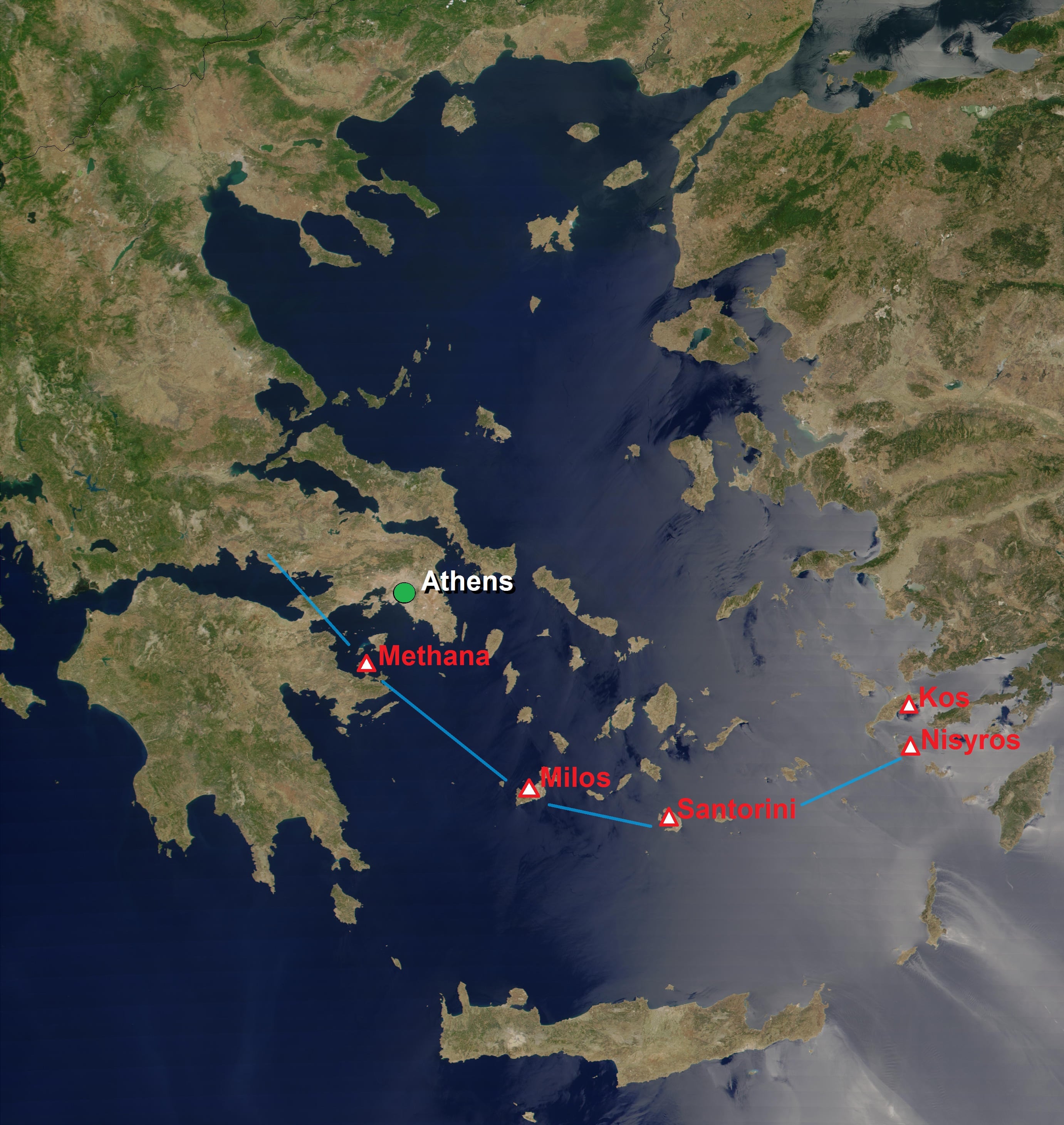
  • Are Extinct Volcanoes actually Dormant? This comes from THIS ARTICLE. And the evidence for this comes from the "extinct" Methana volcano not far from Athens. It seems that zircon crystals formed throughout the volcanoes history, including during long periods of quiescence. Are they still forming now?


    The Southern Aegean Volcanic Arc, showing Methana on the left and Santorini at the bottom. (Giorgostr/Wikimedia Commons)


  • Lots of magma under Tuscany. Tuscany is not known for volcanism but recent seismological studies have indicate that Yellowstone volumes of magma lie 10km under the surface. The academic paper detailing this is HERE. 

Saturday, 2 May 2026

Would You be Scared of this Giant Octopus?

 Would You be Scared of this Giant Octopus?

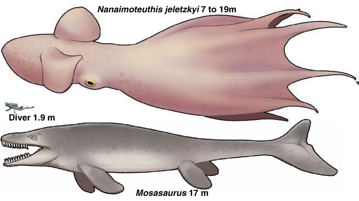
Generally octopuses don't fossilise - they are essentially bags of water. But their beaks are preserved and someone has found some big ones in Cretaceous rocks. And using present day beak sizes and octopus sizes has come to the conclusion that their beaks belonged to an octopus 7 to 19 metres in length!


Cretaceous marine predators (at maximum estimated size) with a scuba diver for scale. Credit: After Ikegami et al. Fig. 4, and Jacobs 2026.

Was the octopus a top predator or was it an extra large food source for a Mosasaurus? It is certainly a very good focus for speculation. Proving anything might be a difficult task.

You can read all about it HERE, based on THIS PAPER

Some New but Old Cambrian Fossils

 Some New (but Old) Cambrian Fossils

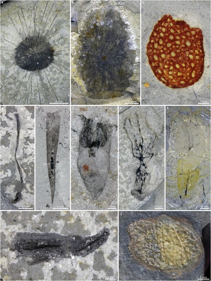
A correspondent sent me THIS LINK (but I had spotted it my self!). It concerns a recently discovered Lagerstätte in Southern China, called the Huayuan biota.

It has an added importance as being just after the first mass extinction of the Phanerozoic. It contains some old favourites from the Burgess Shale but many new species have been identified.

The find is of importance for many reasons but for me it is important for the wonderful photographs of the beasties. The source academic paper is HERE


non-bilaterian metazoans and deuterostomes from the Huayuan biota

Saturday, 25 April 2026

How and Why Etna is Unusual

 How and Why Etna is Unusual

A correspondent sent me THIS LINK. It is based on THIS ACADEMIC PAPER. Both links are quite complex and the best summary of them can be provided by Chat GPT.

The GA will visit Etna this June and I will be there! I look forward to hearing what degree of complexity we hear when we are on the slopes!

Here is ChatGPT's summary.

------------------

The article explains how scientists may finally understand the unusual behaviour of Mount Etna, one of the world’s most active and puzzling volcanoes. Although Etna is over 500,000 years old and sits above a subduction zone where tectonic plates collide, its eruptions don’t match typical volcanic models. Instead of producing the kinds of magma expected in such settings, Etna frequently emits alkaline lava more typical of hotspot volcanoes like those in Hawaii—despite no hotspot being present nearby.

To solve this mystery, researchers analysed the chemistry of Etna’s lava over hundreds of thousands of years. They found that its composition has remained remarkably consistent, even as surrounding tectonic conditions changed. This suggests the magma feeding Etna is not newly formed each time, as in most volcanoes, but instead comes from a long-lasting, stable source deep underground.

The study proposes that Etna is fed by pockets of magma trapped about 80 kilometres beneath the Earth’s surface, in a region between the upper mantle and tectonic plates. As the African Plate moves beneath the Eurasian Plate, pressure squeezes this stored magma upward through cracks in the crust, much like water from a sponge.

This mechanism resembles that of so-called “petit-spot” volcanoes—small volcanic features usually found on the ocean floor. However, Etna is vastly larger, making it an unusual and possibly unique example of this process operating on a massive scale.

These findings reshape scientists’ understanding of how volcanoes can form and function, suggesting Etna may not fit into standard categories. The research also has practical importance, helping improve assessments of volcanic hazards in nearby populated areas such as Catania and Messina.
---------------------


The Hunga-Tonga Eruption Hid its Effect

 The Hunga-Tonga Eruption Hid its Effect

A correspondent sent me THIS LINK. It concerns the 1922 eruption of Hunga-Tonga. This occurred under water and this had the effect of disguising its impact. 

The release of sulphur dioxide (SO₂) is often used to measure the cooling affect of eruptions, but Hunga-Tonga released little SO₂ to the atmosphere. And therefore it was assumed that it had little affect on the climate. The SO₂ released reacted with sea water - I assume sulphuric acid will be somewhere in the reactants.

But the lack of SO₂ in the atmosphere does not mean that the eruption had little climactic affect. 3 billion tons of water vapour went into the atmosphere in 1 hour! And it went very high - into the stratosphere and mesosphere. And there it had complex climatic results.

Read the article to understand some of the complexities!